Heathsville’s post office opened in 1836, and 53% of its homes were built before 1940
9 places in town are on the National Register, among them a historic district with 81 buildings. Below: 1 old photo or paper, maps from 1917 on, and the census since 1980.
In 1679, the county justices of Northumberland County sought to move their courthouse from the Hull Neck area to a more central locale in the county. To that end, local officials signed a contract with John Hughlett in 1680 to build a court house and attached prison upon "Mr. Hughlett's Indian Field," the future site of Heathsville. The court house would be completed the following year.
For most of its early history, Heathsville remained a small hamlet, with fewer than 12 buildings through the American Revolutionary War. These buildings were small, poorly maintained wooden homes that one 1784 court order described as a "public nuisance."
Nothing in the archives for these yearsWeddings on Main Street, storms, parades, school pictures, the old store. If it’s in your family album, it belongs here.
Between 127 and 185 people in every census since 1980.
5 censuses, 1980–2020.
U.S. Census Bureau decennial counts, from the census table on Heathsville’s Wikipedia page.
Questions about Heathsville’s history
What year was Heathsville founded?
The Heathsville post office opened in 1836, the earliest record of the town by name (U.S. post office records).
What is on the National Register in Heathsville?
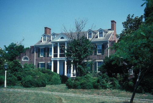
9 listings: 8 buildings, among them the Springfield (listed 1979, the first), and 1 historic district, the Heathsville Historic District, with 81 contributing buildings. 93 historic buildings in all.
Founding dates: Wikidata, Wikipedia, the U.S. post office records of Blevins & Helbock (CC0) and the Census. Homes by year built: Census ACS 2020–24. National Register of Historic Places: National Park Service (list of May 22, 2026). Old photos, postcards and papers: Wikimedia Commons, the Library of Congress and other public archives, credited on each item’s page. Maps: U.S. Geological Survey historical topographic maps (via Esri) and Sanborn fire-insurance maps (Library of Congress). History text and census tables: Wikipedia (CC BY-SA 4.0). Places that used to be: USGS Geographic Names Information System (2021). How TownRatings grades history →
From Wikimedia Commons (2), the Library of Congress (1), the National Register of Historic Places (9), Wikipedia, U.S. Geological Survey historical maps, U.S. Census counts (via Wikipedia), the US Post Offices dataset (Blevins & Helbock) and the USGS Geographic Names Information System. Archive images are copied here with their credits and licenses, shown on each photo’s page. Refreshed monthly.



 2017
 2017


