Bedford dates to 1782, and 11% of its homes were built before 1940
More historic than 83% of U.S. towns · #32 of 253 in Virginia. What drives it
12 places in town are on the National Register, among them two historic districts with 231 buildings between them. Below: 15 old photos and papers, maps from 1891 on, and the census since 1860.
Founding year: Wikidata. First post office: 1794.The full story ↓
History grade
What drives Bedford’s History grade
On its age, its old homes and the National Register, Bedford is more historic than 83% of U.S. towns, #32 of 253 in Virginia. Its National Register listings hold the grade up; its share of homes from before 1940 pulls it down.
A−
HistoryA character grade: shown, never part of Bedford’s overall grade.
Virginia towns list more on the Register than most of the country (a typical Virginia town has 3.6 per 10,000 residents, the U.S. 2.4), so Bedford’s 326 sits above most of its state (84% of Virginia towns have fewer) while its 252 historic buildings outnumber those of 94% of U.S. towns.
NoteThe founding year comes from Wikidata alone; no second source gives 1782.
How sure. Graded on any two of the three inputs instead, the letter would range from B to A. The pre-1940 share is a Census survey estimate (±3.8 points).
Founding year: Wikidata (other dates in Quick answers). Homes: Census ACS 2020–24. National Register: National Park Service, May 2026 list; each listing counted once (boundary changes and added documentation belong to their listing), and a historic district counts its contributing buildings. How TownRatings grades history →
What stands out about Bedford’s past
Read from the archive, the National Register and the record. The page puts what stands out first.
National Park Service, National Register of Historic Places. Photos from Wikimedia Commons, credited on each place’s page.
Every building
Bedford, building by building, 1891–1921
Fire insurance maps drew every building, what it was made of and what it was used for, so insurers could price the risk of fire. Pick a year, then a sheet.
Bedford was originally known as Liberty, "named after the Colonial victory over Cornwallis at Yorktown." Founded as a village in 1782, Liberty became Bedford County's seat of government, replacing New London which had become part of the newly formed Campbell County. Liberty became a town in 1839 and in 1890 changed its name to Bedford City. In 1912, Bedford reverted to town status, it resumed city status in 1968, and once more it reverted to a town in 2013.
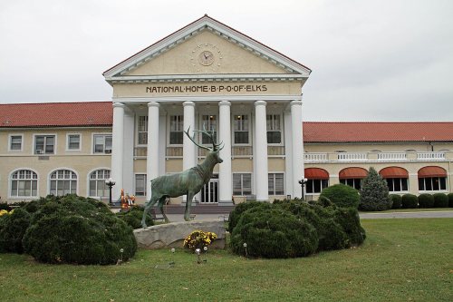
In November 1923, the town was the site of an accidental mass poisoning in which nine men were killed after drinking apple cider served at the Elks National Home. A local farmer had produced the drink and stored in a barrel that had been used to hold a pesticide.
Passages that mention Bedford, cut from the printed page as they were published.
Historical sketch of Bedford County, Virginia. 1753. 19071907 · page 96Read the page →
Read the text
Taking the elevation above the sea level along the line of the Norfolk & Western Railway through Bedford County, beginning at Forest Depot near the Campbell County line on the east, and adopting the new grade figures, we have at Forest Depot 851 feet elevation, at Bellevue 809 feet, at Goode 784 feet, at Dowry 767 feet, at Bedford City 931 feet, at Elk 915 feet, at Thaxton 948 feet, at Irving 968 feet, at Montvale 996 feet, at the Summit east of the Blue Eidge Station 1,281 feet. At and near all of these
Text read by machine from the scan; it may contain errors.
Taking the elevation above the sea level along the line of the- Norfolk & Western Railway through Bedford County, beginning at Forest Depot near the Campbell County line on the east, and adopting the new grade figures, we have at Forest Depot 851 feet elevation, at Bellevue 809 feet, at Goode 784 feet, at Lowry 767 feet, at Bedford City 931 feet, at Elk 915 feet, at Thaxton 948 feet, at Irving 968 feet, at Montvale 996 feet, at the Summit east of the Blue Ridge Station 1,281 feet. At and near all of these
Text read by machine from the scan; it may contain errors.
Historical sketch of Bedford County, Virginia. 1753. 19071907 · page 91Read the page →
Read the text
In no city in this State can be found a better banking system than that of Bedford City. The bank officers are some of the keenest business men and ablest financiers of the State, while the directors are men, who have made a success financially, in whatever business or profession they may be engaged. Bedford City has two banking institutions, the Bedford City branch of the Lynchburg Trust and Savings Bank, and the Peoples Bank of Bedford City.
Text read by machine from the scan; it may contain errors.
In no city in this State can be fonnd a better banking system than that of Bedford City. The bank officers are some of the keenest business men and ablest financiers of the State, while the directors are men, who have miade a success financially, in whatever business or profession they may be engaged. Bedford City has two banking institutions, the Bedford City branch of the Lynchburg Trust and Savings Bank, and the Peoples Bank of Bedford City.
Text read by machine from the scan; it may contain errors.
Scans and text from the Internet Archive. Books published in 1930 or earlier, which are in the public domain.
Timeline
Bedford, 1782 to 1984
Woven from the archive, old maps, post office records, the National Register and the people born here.
Nothing in the archives for these yearsWeddings on Main Street, storms, parades, school pictures, the old store. If it’s in your family album, it belongs here.
In 1782, according to Wikidata. Bedford’s post office opened in 1794, and the census of 1860 counted 722 people here.
How does Bedford rank for history?
Bedford is more historic than 83% of U.S. towns, #32 of 253 in Virginia. The History grade combines the town’s founding era, the share of homes built before 1940 and its National Register listings. It’s a character grade, so it isn’t part of the overall grade. How it works.
What is on the National Register in Bedford?
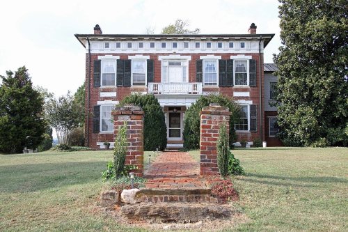
12 listings: 10 buildings, among them the Three Otters (listed 1970, the first), and 2 historic districts, the Bedford Historic District and the Elks National Home, with 231 contributing buildings. 252 historic buildings in all.
How old are the homes in Bedford?
11% of Bedford’s homes were built before 1940 (Census estimate, ±3.8 points), against a typical 1.9% for a Virginia town; the median home was built in 1973.
Founding dates: Wikidata, Wikipedia, the U.S. post office records of Blevins & Helbock (CC0) and the Census. Homes by year built: Census ACS 2020–24. National Register of Historic Places: National Park Service (list of May 22, 2026). Old photos, postcards and papers: Wikimedia Commons, the Library of Congress and other public archives, credited on each item’s page. Maps: U.S. Geological Survey historical topographic maps (via Esri) and Sanborn fire-insurance maps (Library of Congress). History text and census tables: Wikipedia (CC BY-SA 4.0). Places that used to be: USGS Geographic Names Information System (2021).
From Wikimedia Commons (13), the Library of Congress (5), the National Register of Historic Places (12), Wikipedia, Wikidata and Wikipedia for famous people, U.S. Geological Survey historical maps, U.S. Census counts (via Wikipedia), the US Post Offices dataset (Blevins & Helbock), the USGS Geographic Names Information System, Sanborn fire insurance maps (Library of Congress) and old county and town histories (Internet Archive). Archive images are copied here with their credits and licenses, shown on each photo’s page. Refreshed monthly.






 1916
 1941
 1968
 1968
 1968
 1968
 1968
 1968
 1968
 1968
 2006
 2006
 2005


