Springville dates to 1850, and 27 of its places are on the National Register
More historic than 63% of U.S. towns · #23 of 119 in Utah. What drives it
Most of Springville was built recently: 7% of its homes predate 1940 and the median home dates from 1996. 27 places in town are on the National Register, among them a historic district with 891 buildings. Below: maps from 1890 on and the census since 1860.
Founding year: Wikidata; Wikipedia’s history section gives the same year. First post office: 1851.The full story ↓
History grade
What drives Springville’s History grade
On its age, its old homes and the National Register, Springville is more historic than 63% of U.S. towns, #23 of 119 in Utah. Its National Register listings hold the grade up; its age pulls it down.
B
HistoryA character grade: shown, never part of Springville’s overall grade.
Utah towns list more on the Register than most of the country (a typical Utah town has 3.0 per 10,000 residents, the U.S. 2.4), so Springville’s 258 sits above most of its state (95% of Utah towns have fewer) while its 925 historic buildings outnumber those of 99% of U.S. towns.
How sure. Graded on any two of the three inputs instead, the letter would range from C to A−. The pre-1940 share (±1.5 points) is firm at this size. Two sources give 1850.
Founding year: Wikidata (other dates in Quick answers). Homes: Census ACS 2020–24. National Register: National Park Service, May 2026 list; each listing counted once (boundary changes and added documentation belong to their listing), and a historic district counts its contributing buildings. How TownRatings grades history →
What stands out about Springville’s past
Read from the archive, the National Register and the record. The page puts what stands out first.
The first European explorer of what is now Springville was Father Silvestre Vélez de Escalante, a Franciscan padre, in 1776. What became Springville lay along the wagon route called the Mormon Road that Mormon pioneers and 49ers traveled through southern Utah, northern Arizona, southern Nevada and Southern California. From 1855, each winter trains of freight wagons traveled on this road across the deserts between Los Angeles and Salt Lake City until the late 1860s when the railroad arrived in Utah. During the year 1849, a group of pioneers led by William Miller and James Mendenhall traveled to the Provo River area. Mendenhall and Miller explored a little further south and fell in love with what is now known as the Hobble Creek area. Springville was settled in 1850 by eight pioneer families, led by Aaron Johnson, who crossed the plains to Salt Lake Valley from the East and were directed …
Passages that mention Springville, cut from the printed page as they were published.
A brief history of Springville, Utah1900 · page 111Read the page →
Read the text
II. M. Dougall came to Springville. with his widowed mother, in 1856. <lirect from England, lie has been known as a freighter and railroad contractor, before the advent of the railway, in 1868. and as sawmill and gristmill owner in the more recent times, all of which business prospered
Text read by machine from the scan; it may contain errors.
A brief history of Springville, Utah1900 · page 55Read the page →
Read the text
warrants for many prominent men in Utah county, including all the civil, military and ecclesiastical authorities of Springville. for the killing of the Parishes and Forbes. An amusing incident occurred in Springville during the session of court, that will show tinstate of affairs and illustrate how de-
Text read by machine from the scan; it may contain errors.
Scans and text from the Internet Archive. Books published in 1930 or earlier, which are in the public domain.
Timeline
Springville, 1850 to 2020
Woven from the archive, old maps, post office records, the National Register and the people born here.
Every edition of the U.S. Geological Survey’s map of Springville. Tap a year, or press play to watch the town change.
1948Springville sheet · 1:24,000
U.S. Geological Survey historical topographic maps (public domain), via Esri’s collection of the scans. The red ring marks the center of Springville.
Every building
Springville, building by building, 1890–1908
Fire insurance maps drew every building, what it was made of and what it was used for, so insurers could price the risk of fire. Pick a year, then a sheet.
In 1850, according to Wikidata and Wikipedia’s history of the town. Springville’s post office opened in 1851, and the census of 1860 counted 1,357 people here.
How does Springville rank for history?
Springville is more historic than 63% of U.S. towns, #23 of 119 in Utah. The History grade combines the town’s founding era, the share of homes built before 1940 and its National Register listings. It’s a character grade, so it isn’t part of the overall grade. How it works.
What is on the National Register in Springville?
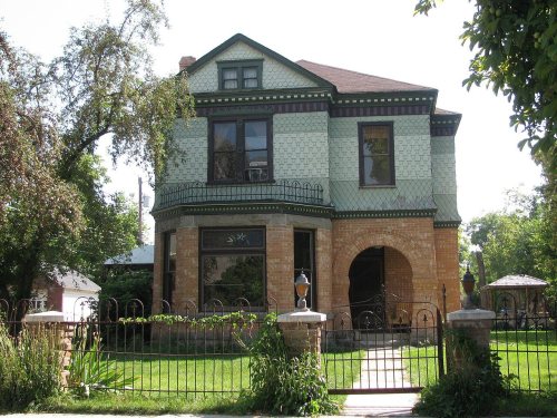
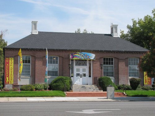
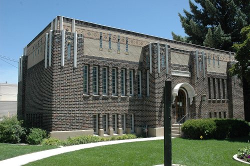
27 listings: 26 buildings, among them the Springville Presbyterian Church (listed 1980, the first), and 1 historic district, the Springville Historic District, with 891 contributing buildings. 925 historic buildings in all.
How old are the homes in Springville?
7% of Springville’s homes were built before 1940 (Census estimate, ±1.5 points), against a typical 2.8% for an Utah town; the median home was built in 1996.
Founding dates: Wikidata, Wikipedia, the U.S. post office records of Blevins & Helbock (CC0) and the Census. Homes by year built: Census ACS 2020–24. National Register of Historic Places: National Park Service (list of May 22, 2026). Old photos, postcards and papers: Wikimedia Commons, the Library of Congress and other public archives, credited on each item’s page. Maps: U.S. Geological Survey historical topographic maps (via Esri) and Sanborn fire-insurance maps (Library of Congress). History text and census tables: Wikipedia (CC BY-SA 4.0). Places that used to be: USGS Geographic Names Information System (2021).
From Wikimedia Commons (9), Wikidata (8), the National Register of Historic Places (27), Wikipedia, Wikidata and Wikipedia for famous people, U.S. Geological Survey historical maps, U.S. Census counts (via Wikipedia), the US Post Offices dataset (Blevins & Helbock), the USGS Geographic Names Information System, Sanborn fire insurance maps (Library of Congress) and old county and town histories (Internet Archive). Archive images are copied here with their credits and licenses, shown on each photo’s page. Refreshed monthly.







 2006
 2004
 2004
 2004
 2004
 2004
 2004
 2004
 2004


