175 years in pictures
Census counts: 179 in 1860, a low of 179 in 1860, 9,298 in 2020. The archive holds 12 old photos and papers going back to 1895 and 5 maps from 1948 on.
1 place on the National Register of Historic Places.
- 1851Salem is settled
Each edition grades its towns against each other only.

Salem grades A− overall, 60th among Utah's 118 graded towns, with clear strengths and some subjects that lag. Residents are healthier than 94% of U.S. towns on CDC estimates and the median household earns $111K. It also does better than most on schools: its schools outperform 68% of the state's. Its lowest everyday mark is in cost of living: the typical home is worth about $600K, 6 years of the Provo metro’s $101K median household income. 36% of residents are under 18 in Salem, where Utah’s towns sit at 30% and U.S. towns at 22%. Among 63 Utah towns, just 1 have a lower violent crime rate than Salem. Ira W. Gardner House is on the National Register of Historic Places.
Where Salem beats most towns.
6,423 counted in 2010 and 9,298 in 2020; an estimated 12,234 in 2025.
Growth hasn’t slowed: 31.6% since 2020, after 44.8% in the decade before.
U.S. Census 2010 & 2020 counts · Census Bureau estimate, July 1, 2025
Each subject compared with towns across the country (schools within Utah), ordered by how far Salem is from typical.
How TownRatings grades towns →
Census counts: 179 in 1860, a low of 179 in 1860, 9,298 in 2020. The archive holds 12 old photos and papers going back to 1895 and 5 maps from 1948 on.
1 place on the National Register of Historic Places.
Museums, parks, gardens and other places to visit around Salem. Close and well known come first.
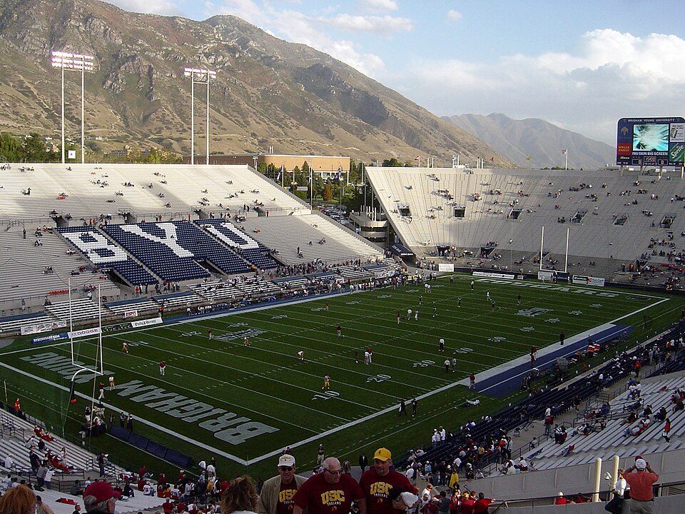
14 mi Stadium & arenaLaVell Edwards Stadium22 mi Theme parkEvermore Park
13 mi LakeUtah Lake
23 mi MountainMount Timpanogos
38 mi Stadium & arenaAmerica First Field
19 mi Canyon & gorgeProvo CanyonLaVell Edwards Stadium: The original uploader was Bobak at English Wikipedia., CC BY-SA 2.5 · Utah Lake: NASA Earth Observatory images by Lauren Dauphin, using Landsat data from the U.S, Public domain · Mount Timpanogos: Eric Ward from Provo, UT, USA, CC BY-SA 2.0 · America First Field: Scott Catron, CC BY-SA 2.0 · Provo Canyon: Eric Ward from Provo, UT, USA, CC BY-SA 2.0
Who provides power, water and the rest in Salem, and how to reach them.
EPA SDWIS (Oct 9, 2026) · HIFLD + EIA-861 2025 · Census 2020 ZCTAs · NCES 2024–25 · registration: vote.gov, updated Mar 13, 2026.
Ordered by what stands out in Salem.
8.7% of Salem adults binge drink. Salem beats the Utah average on 12 of 32 CDC measures and trails it on 1. 14% of Salem adults get no exercise outside work.
| Salem | Utah towns | U.S. towns | |
|---|---|---|---|
| Binge drink (CDC PLACES) | 8.7% | 11% | 16% |
| Get no exercise (CDC PLACES) | 14% | 17% | 25% |
| Smoke cigarettes (CDC PLACES) | 6.7% | 8% | 14% |
| Yearly checkup (CDC PLACES) | 71% | 72% | 79% |
| What stands out | Salem | UT |
|---|---|---|
| Fewer adults facing food insecurity | 8.3% | 12.4% |
| Fewer binge drinkers | 8.7% | 12.4% |
| More adults who have had cancer | 8.2% | 7.2% |
CDC PLACES 2025 · modeled estimates for adults · CMS · HRSA
Its public schools are run by the Nebo District. Two of its 9 schools are below, each with why it’s listed. The largest public high school is Salem Hills High, with 1,593 students.
| School | Level | Students | Letter |
|---|---|---|---|
| Valley View MiddleLargest public middle schoolGrades 6–7 | Grades 6–7 | 963 | C+ |
| Salem Hills HighLargest public high schoolGrades 9–12 | Grades 9–12 | 1,593 | C+ |
NCES · EDFacts · graded within UT on state tests and graduation
Jobs based here grew from 1,185 in 2013 to 2,166.
Most working residents leave Salem for work: only 6% work in town. Jobs based in Salem grew to 2,166 in 2023, 981 more than in 2013. 4.2% of residents live below the poverty line in Salem.
| Salem | Utah towns | U.S. towns | |
|---|---|---|---|
| Median household income | $111,000 | $101,000 | $80,000 |
| Below the poverty line | 4.2% | 6.4% | 9.6% |
| Work from home | 14% | 16% | 11% |
| Average trip to work | 24 minutes | 22 minutes | 25 minutes |
Census LEHD 2023 · ACS
9.6 miles of trail in 6 parks and preserves. Among 117 Utah towns, just 2 have a lower share of conserved land than Salem. The biggest park or preserve is Salem Pond, at 24 acres.
| Salem | Utah towns | U.S. towns | |
|---|---|---|---|
| Conserved land | 0.4% | 3.5% | 4.3% |
| Miles of trail per square mile | 0.8 miles per square mile | 1.1 | 0.4 |
| Biggest places to walk | Trails | Acres |
|---|---|---|
| 1. Cole Park | 0.4 mi | 6 |
| 2. Salem Pond | 0.2 mi | 24 |
| 3. Salem Loafer View Recreational Complex | — | 14 |
Trails & parks © OpenStreetMap contributors · Conserved land: USGS PAD-US
Salem has chilly, snowy winters and hot summers, with very little rain. Salem’s July high is 93°F.
NOAA U.S. Climate Normals, 1991–2020
Children under 18 are 36% of residents (28% statewide); adults 18 to 34 are 22% of residents (26% statewide). The median age in Salem is 29.3 years. Salem has grown 32% since 2020, to 12,234 residents in the Census Bureau’s 2025 estimate.
| Salem | Utah towns | U.S. towns | |
|---|---|---|---|
| Median age | 29.3 years | 32.7 years | 40.5 years |
| Aged 65 or older | 9.8% | 11% | 18% |
| Bachelor’s degree or more, 25+ | 39% | 36% | 29% |
52% women, 48% men
That’s an even split within the survey’s margin of ±2.4 points. Across Utah, 49.3% of residents are women. Median age: women 28.3, men 30.5.
| Salem | UT | U.S. | |
|---|---|---|---|
| Under 10 | 20.2% | 14.6% | 11.6% |
| 10 to 17 | 15.6% | 13.2% | 10.3% |
| 18 to 24 | 9.1% | 11.6% | 9.1% |
| 25 to 34 | 12.5% | 14.8% | 13.7% |
| 35 to 44 | 11.8% | 13.8% | 13.2% |
| 45 to 54 | 11.8% | 11% | 12.2% |
| 55 to 64 | 9.2% | 9.1% | 12.7% |
| 65 to 74 | 6.6% | 7.3% | 10.2% |
| 75 and older | 3.2% | 4.6% | 7% |
| No diploma | 2.3% | 6.6% | 10.4% |
| High school | 14.5% | 22.3% | 26% |
| Some college | 33.6% | 23.5% | 19.1% |
| Associate’s | 10.6% | 9.9% | 8.8% |
| Bachelor’s | 26.4% | 24.7% | 21.6% |
| Graduate | 12.6% | 13% | 14.1% |
Census population estimates, 2025 · U.S. Census Bureau · ACS 2020-2024 5-year estimates
Expected storm and flood damage is higher than in 64% of U.S. communities.
FEMA National Risk Index · OpenFEMA
The typical Salem home is worth about $600,000, up 2.4% in a year, 13% above the Utah typical home.
Zillow Home Value Index · Redfin Data Center
Salem's reported crime rate is well below Utah's. Most reported incidents are property crimes, mainly thefts. Violent crime is rare: 1 reported in 2024.
FBI crime data, 2024 · crimes reported to police
3 within 15 miles of the center of Salem
About 5 of every 100 Salem residents are enrolled in college, against 8 across Utah.
Where Salem’s working residents go each day. Line width shows the share.
Census LEHD 2023
City in Utah, United States
Salem is a city in Utah County, Utah. It is part of the Provo–Orem metropolitan area. The population was 9,298 at the time of the 2020 U.S. census. Landmark locations in Salem include the Dream Mine of John Hyrum Koyle and the Salem Pond.
From Wikipedia, licensed CC BY-SA 4.0 · facts via Wikidata (CC0)
4 towns share a border with Salem.
| Town | UT rank | Overall | Cost | Safety | Schools | Health |
|---|---|---|---|---|---|---|
| Salem | #60 | A− | C+ | — | B+ | A |
| Woodland Hills | — | — | C− | — | B+ | A |
| Payson | #35 | A | B− | B+ | B+ | A |
| Spanish Fork | #28 | A | B− | B+ | B+ | A |
| Elk Ridge | #67 | B+ | C+ | — | B+ | A+ |
Woodland Hills has fewer than 2,500 residents, so it gets subject grades but no overall grade. Salem, Woodland Hills and Elk Ridge report no FBI crime data of their own. Compare Salem with a neighbor →
Short answers, built from the data on this page.
By most measures, yes. Salem grades A− overall, better than 76% of U.S. towns and #60 of 118 in Utah. It grades A for health and B+ for schools.