Guest, Sign inJoin
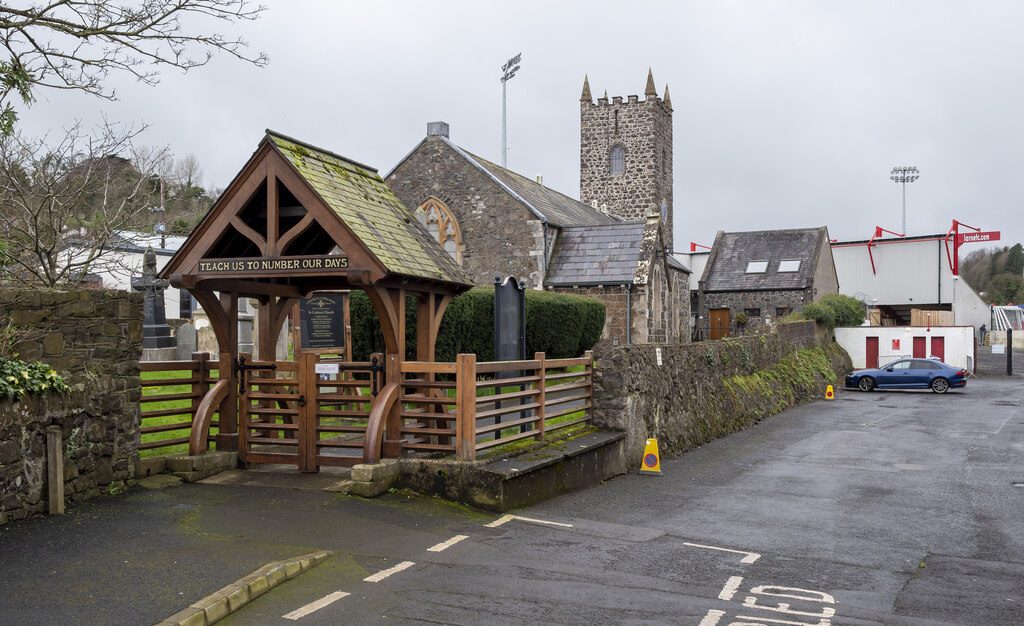
St Cedma's parish church, Larne
UK›Mid and East Antrim›Northern Ireland

LarneMid and East Antrim

18,853 people call this town in Mid and East Antrim, Northern Ireland home. The average domestic rates bill is £1,177 a year.

4 places within 12 milesMap →
Photo: Rossographer · CC BY-SA 2.0
St Cedma's parish church, Larne

Larne, Mid and East Antrim · Photo: Rossographer · CC BY-SA 2.0

Is Larne a good place to live?

What it saves you on housing, it gives back elsewhere. Larne’s overall grade is B, better than 60% of UK towns. In the ranking it comes #48 of 63 in Northern Ireland. Cost of living is its strong suit — the median home sold for £123,300, 2.5 years of area income. The drawback is health — life expectancy is 77.9 for men and 83.9 for women. Safety is weaker too — 27.8 violent or sexual offences per 1,000 residents a year, plus 11.4 home and vehicle crimes. Only 64% of UK towns of 10,000 to 50,000 people have more crime per resident. Its remaining grades are unremarkable: C+ for schools and B− for walkability.

Figures: prices, HM Land Registry (LPS), 2022 to 2024 at early-2025 prices · life expectancy, ONS · crime, police.uk, averaged Sep 2023 to Aug 2026 · commuting, Census 2021.

This town's Cost Grade uses house prices and the domestic rates bill: Northern Ireland has no council tax, and no rents are published for its council areas. This town's Health Grade uses NISRA's life expectancy for its district electoral area (2022 to 2024) and two Census 2021 measures, bad health and disability, adjusted for age. Healthy life expectancy and the early-death and hospital measures English towns use aren't published for small areas in Northern Ireland. This town's School Grade uses GCSE results at the post-primary schools its children travel to, grammar and non-grammar, compared with schools across Northern Ireland. Northern Ireland publishes no primary school results. Northern Ireland has no Jobs Grade (no small-area income, claimant or job-access data is published) and no Hazards Grade (its flood maps aren't open data).
What makes Larne stand out

The 2 things Larne does most differently from other towns.

Picked automatically from the data

How Larne grades

Each subject compared with the 2,160 UK towns with an overall grade (schools within Northern Ireland), ordered by how far Larne is from typical. American towns are graded separately.

How grading works

How TownRatings grades towns →

Town Hall, Upper Cross Street
Town Hall, Upper Cross Street · Grade II* listed · Photo: Kenneth Allen · CC BY-SA 2.0
Larne’s story

Larne in pictures

The Historic Environment Division lists 29 buildings inside Larne’s settlement, 4 of them in the second grade.

Explore the history →

The data

Data highlights are ordered by what stands out in Larne.

HousingCost of living grade A+

Private renting is more common in Larne than in Mid and East Antrim’s towns or Northern Ireland’s towns: 22% of households

14% live in social housing, below Mid and East Antrim’s towns (16%) and Northern Ireland’s towns (20%) alike. No town in Mid and East Antrim costs less to buy into than Larne, at £123,300, the lowest of 8. Owners make up 63% of households.

£123Kmedian sale

Median sale price · 2022 to 2024, at early-2025 prices

Larne£123K
Typical UK town£277K
63%
of households own their home · Northern Ireland 59%
22%
rent privately · Northern Ireland 19%
£1,177
average domestic rates bill, 2026–27 (no council tax in Northern Ireland)

NISRA / Land & Property Services ward sale prices and domestic rates · NISRA Census 2021 tenure · OGL · The figure is NISRA’s median sale price for the wards around Larne, 2022 to 2024, brought to early-2025 prices and weighted by sales.

SchoolsC+

On exam results, Larne’s schools trail 60% of Northern Ireland towns

Larne’s seven primaries and two secondaries have 3,111 pupils between them. Below are two of its 11 schools, each with why it was picked.

C+School Grade
SchoolLevelPupilsLetter
Moyle Primary SchoolLargest primary schoolPrimaryPrimary422–
Larne High SchoolLargest post-primary schoolPost-primaryPost-primary833C
Department of Education (NI) · school census and exam results · The grade uses the post-primary schools in or within 10 km; Northern Ireland publishes no primary results.See all 11 schools →
Health

More people in Larne live with a disability than in Mid and East Antrim’s towns or across Northern Ireland’s towns: 28%

Larne’s share in bad or very bad health, 8.9%, is the second highest of the 8 towns in Mid and East Antrim. Self-reported good health: 75% of the town’s residents. Also worth knowing: men in Larne can expect to live to 77.9, women to 83.9 (2022–24).

75%good or very good healthC−Health Grade
General health, self-reported
Good or very good 75%Fair 16%Bad or very bad 9%
Census 2021LarneMid and East AntrimNorthern Ireland
Good or very good health75%76%77%
Bad or very bad health8.9%8.3%8.7%
Disabled (Equality Act)28%27%26%
77.9
life expectancy at birth, men (2022–24)
83.9
life expectancy at birth, women
Northern Ireland towns’ Health Grades use NISRA’s life expectancy for 2022 to 2024 in the district electoral areas around the town, and two Census 2021 measures, bad health and disability, adjusted for age to the same standard as England and Wales. Healthy life expectancy isn’t published for Northern Ireland’s areas, and its early-death, hospital and child-obesity figures cover district electoral areas or council areas rather than small areas, so the Health page compares those with Northern Ireland without grading them.

NISRA Census 2021, general health and disability · NISRA life expectancy by district electoral area, 2022–24 · OGL · Because the census answers ignore age, a younger population lifts them; that is why the Health Grade is built on age-adjusted measures like life expectancy.

Safety

Larne records more crime per resident than 63% of UK towns

Reported offences in Larne came to 893 over twelve months to August 2026; nuisance and anti-social incidents added 480. There were 25.9 anti-social behaviour reports per 1,000 residents (not graded), higher than both Mid and East Antrim’s towns (18.7) and Northern Ireland’s towns (20.7). Violence and sexual offences made up 53% of the total.

27.8violent and sexual offences per 1,000 a yearC+Safety Grade
Compared with UK towns its sizeLess crime per resident than 64% of the 645 UK towns of 10,000 to 50,000 people: about the middle for its size. Context only, not part of the grade.

Reports by type · Sep 2025 to Aug 2026

Violence & sexual470
Damage & arson137
Drugs86
Shoplifting57
Other theft52
Burglary31
Other crime22
Vehicle crime17
Anti-social480

Not gradedAnti-social behaviour, shoplifting and other theft are shown but left out of the Safety Grade, which counts violence and crimes against homes and vehicles per resident.

27.8
violent and sexual offences per 1,000 residents a year, averaged Sep 2023 to Aug 2026
11.4
burglary, vehicle crime and damage per 1,000 a year, averaged Sep 2023 to Aug 2026
25.9
anti-social behaviour reports per 1,000 (not graded)
893
crimes recorded in the 12 months to August 2026

data.police.uk street-level crime · points inside the NISRA settlement boundary · OGL · The police category of violence and sexual offences includes harassment and stalking.

History

Larne’s heritage list runs to 29 buildings

The heritage lists give each building’s grade but not its age, so we don’t say which is oldest.

Grade B+ covers 4 of them. For its size, Larne has 15 listed buildings per 10,000 residents, lower than both Mid and East Antrim’s towns (35) and Northern Ireland’s towns (34). 2 historic parks, gardens and demesnes lie locally.

29listed buildings

Listed buildings by grade · HED

Grade A0
Grade B+4
Grade B25

Among them · Grade B+

  • Drumalis Retreat Centre Grade B+
  • Lisnamoyle, 119 The Roddens Grade B+
  • St Cedma’s C of I Church Grade B+
  • Town Hall, Upper Cross Street Grade B+
0
scheduled monuments
2
historic parks, gardens and demesnes
15
listed buildings per 10,000 residents · typical town in England and Wales 24

HED list, October 2026 · Valuation Office Agency, homes by build period · OGL

Work & commute

Larne has 0.8 jobs for every resident in work, so most commute out

The Census was taken on 21 March 2021, in lockdown, so 14% of workers were mainly at home; shares here are of those who travelled.

14% of commuters walked, cycled or took the bus or train at the census, close to Mid and East Antrim’s towns (15%) and below Northern Ireland’s towns (18%). About 46% of its commuters stay in Larne for work.

14%walk, cycle or ride

How commuters got to work · March 2021

Driving84%
On foot10%
Bus3%
Train1%
14%
worked mainly from home in March 2021
B−
Walkability: more walkable than 53% of UK towns

NISRA Census 2021, method of travel to work · OGL

Who lives here

Degrees are less common in Larne than in Mid and East Antrim’s towns or across Northern Ireland’s towns: 24% of adults

A fifth of residents are 65 or over. Ages in Larne split evenly at 43.5: half are older, half younger. Young adults of 15 to 24 are 11% of the population.

43.5median age
LarneMid and East AntrimNorthern Ireland

Ages · share of residents

Qualifications · residents 16 and older

No qualifications26%
A levels or similar17%
Degree level24%

Women and men · all residents

51% women, 49% men

About 95 men for every 100 women. Across Northern Ireland, 51% of residents are women.

Ages and qualifications in Larne
LarneMid and East AntrimNorthern Ireland
Under 1517%17%19%
15–2411%11%12%
25–4424%25%27%
45–6428%28%26%
65+20%20%17%
No qualifications26%26%25%
A levels or similar17%16%16%
Degree level24%27%32%

NISRA Census 2021 · Mid and East Antrim and Northern Ireland: all residents of their settlements · Women and men: whole data zones, which approximate the town’s boundary · OGL

Nearby attractions

Olderfleet Castle and 8 more in and around Larne

Museums, castles, gardens and days out in and near Larne. Best known first.

All attractions →
Places: © OpenStreetMap contributors · Wikidata

Photos: each place’s Wikidata image, from Wikimedia Commons under the licence below (our copy, resized).

Photo credits (3)
Keep exploring

Everything we know about Larne

12pages on Larne

Landmarks

29 listed buildings in Larne.

All landmarks →
Photo credits

Drumalis: Photo: Kenneth Allen · CC BY-SA 2.0 · Geograph · St Cedma’s C of I Church: Photo: Albert Bridge · CC BY-SA 2.0 · Methodist Church: Photo: Kenneth Allen · CC BY-SA 2.0 · Geograph · Bank of Ireland: Photo: Kenneth Allen · CC BY-SA 2.0 · Geograph

Famous people from Larne

56 notable people were born in Larne.

See all 56 →
Photo credits

Gareth McAuley: Warwick Gastinger, CC BY-SA 2.0 · Valerie Hobson: Jack Freulich, Public domain · Keith Gillespie: wonker, CC BY-SA 2.0 · Jeff Hughes: Mattythewhite, CC BY-SA 3.0 · Jonny Steele: Username: betancourt, from Flickr, CC BY 2.0 · Arthur McCashin: United Press, Public domain

Larne’s neighbours

The nearest settlements, from NISRA’s 2015 boundaries. See them on the map →

All towns in Mid and East Antrim →
WhiteheadCarrickfergusBallyclareGreenislandWhiteheadCarrickfergusBallyclareGreenislandLarne
How the neighbours grade
TownPeopleMilesOverallCostSafetyHealth
Larne18,853—BA+C+C−
Whitehead3,5378.4B+A+B+C−
Carrickfergus28,1419BA+B+C−
Ballyclare10,8509.9BA+A−C−
Greenisland5,38311A−A+A−C+

People: Census 2021. Miles: centre to centre.

Questions about Larne

Is Larne expensive to live in?

Homes cost less than in most UK towns: the median sale in 2022 to 2024, at early-2025 prices, was £123,300, against £277,000 in the typical UK town. On cost of living it is the most affordable of 63 Northern Ireland towns.

How much are the rates in Larne?

Northern Ireland has no council tax: homes pay domestic rates, set on the home’s capital value, and the rates also pay for water. The average bill in Mid and East Antrim is about £1,177 a year for 2026–27, against England’s average council tax per home of £1,868. Your own bill depends on your home’s value; check it with Land & Property Services on nidirect.

Is Larne safe?

About the middle for its size: 36% of the 645 UK towns of 10,000 to 50,000 people report less crime per resident. Against all UK towns, most of them smaller, it grades C+.

About Larne

Town in Mid and East Antrim, Northern Ireland

Larne is a settlement of 18,853 people, in the Mid and East Antrim council area. TownRatings uses NISRA’s settlements (the 2015 Settlement Development Limits) as Northern Ireland’s towns: the physical town, as people mean the word, rather than a council district, so its figures cover the town itself.

Built from NISRA geography and Census 2021

Population
18,853 (Census 2021)
Council
Mid and East Antrim
Nation
Northern Ireland
Area
3.6 sq mi (9.2 km²)
NISRA code
N11000389

Sources: NISRA Census 2021, data zones best-fitted to the NISRA Settlement Development Limits 2015 (settlement totals from NISRA where it publishes them) · NISRA / Land & Property Services verified residential sales by ward, 2005 to 2024, new and existing dwellings (medians; the 2022 to 2024 headline brought to early-2025 prices with the LPS house price index, which runs to 2026) · Land & Property Services domestic rates paid by council, 2025-26, and Department of Finance rate poundages 2026-27 · data.police.uk street-level crime (Police Service of Northern Ireland), 36 months to August 2026, points inside the settlement boundary · NISRA life expectancy by district electoral area (2022 to 2024) and NISRA Census 2021 general health and disability, adjusted for age · ONS gross disposable household income by council (2022), scaled to household income on England and Wales’s councils · Department of Education examination performance at post-primary schools 2024/25 and school-level enrolment data 2025/26 · TownRatings grades: our own summary of the data, ranked against UK towns only. All under the Open Government Licence v3.0.

Contains public sector information licensed under the Open Government Licence v3.0. Contains HM Land Registry data © Crown copyright and database right 2026. Contains OS data © Crown copyright and database right 2026 (ONS boundaries). Northern Ireland: Source: NISRA; contains Land & Property Services data and Ordnance Survey of Northern Ireland information, © Crown copyright, licensed under the Open Government Licence v3.0. Scotland: contains National Records of Scotland data, Registers of Scotland data and SEPA data, © Crown copyright / © SEPA 2025, licensed under the Open Government Licence v3.0.