Colney Heath’s story
7 listed buildings
Historic England lists them inside Colney Heath’s built-up area.
12% of its homes were built before 1919, against 15% in the typical UK town.
Explore the history →Each edition grades its towns against each other only.
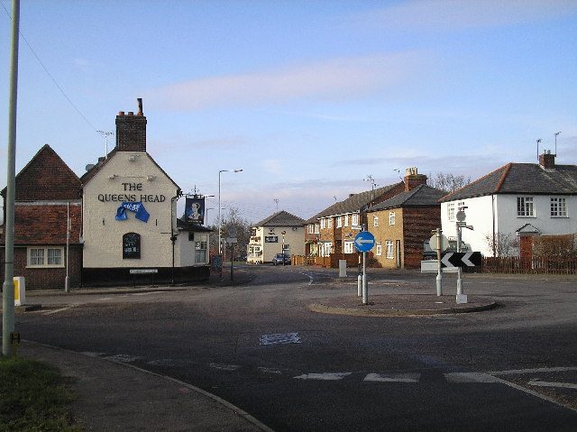
Home to 1,059 people, this village lies in Hertfordshire, East of England.
Jobs and pay hold up well (B+): households earn a mean £71,877 a year, and 3.2% of 16 to 64s claim unemployment benefits. Cost of living is its weak spot (C) — a typical home costs £605,000 and rent runs £1,877 a month. Elsewhere it is close to typical: B for schools, B for health and B− for walkability. Natural hazards are less of a worry than in most UK towns (A).
Figures: income and life expectancy, ONS · claimants, DWP · prices, HM Land Registry, the last three years · commuting, Census 2021 · flood risk, Environment Agency. Colney Heath has fewer than 2,500 residents, so it gets subject grades but no overall grade.
Each subject compared with the 2,160 UK towns with an overall grade (schools within England), ordered by how far Colney Heath is from typical. American towns are graded separately.
How TownRatings grades towns →
The 3 things Colney Heath does most differently from other towns.
Historic England lists them inside Colney Heath’s built-up area.
12% of its homes were built before 1919, against 15% in the typical UK town.
Explore the history →Data highlights are ordered by what stands out in Colney Heath.
Households that own their home make up 71%. Social housing holds just over a fifth of households, above both Hertfordshire’s towns (18%) and England’s towns (18%). Behind the median of £605,000: 49 standard sales inside Colney Heath’s built-up area, September 2023 to August 2026.
| By type | Median | Sales |
|---|---|---|
| Detached | £843,895 | 14 |
| Semi-detached | £587,500 | 26 |
| Terraced | £475,000 | 8 |
HM Land Registry Price Paid · ONS private rents · MHCLG / Welsh Government council tax · ONS Census 2021 tenure · OGL
The heritage lists give each building’s grade but not its age, so we don’t say which is oldest.
12% of homes were built before 1919. Colney Heath has 66 listed buildings for every 10,000 residents.
Historic England list, October 2026 · Valuation Office Agency, homes by build period · OGL
Of all the crimes, 42% were violence and sexual offences. A year of reports to August 2026 adds up to 59 offences in Colney Heath and 13 cases of nuisance behaviour. Among the 1,541 UK towns of 1,000 to 2,500 people, Colney Heath has more crime per resident than 79% of them.
Not gradedAnti-social behaviour, shoplifting and other theft are shown but left out of the Safety Grade, which counts violence and crimes against homes and vehicles per resident.
data.police.uk street-level crime · points inside the ONS built-up-area boundary · OGL · The police category of violence and sexual offences includes harassment and stalking.
The nearest A&E to Colney Heath is Barnet General Hospital, 6.2 miles away. Seeing a GP means leaving Colney Heath: the nearest practice is 1.9 miles away. Women here live to 85.2 on average and men to 80.9 (2019–23).
| Census 2021 | Colney Heath | Hertfordshire | England |
|---|---|---|---|
| Good or very good health | 84% | 85% | 82% |
| Bad or very bad health | 4.3% | 3.8% | 5.2% |
| Disabled (Equality Act) | 17% | 14% | 17% |
ONS Census 2021, general health and disability · OHID Fingertips, life expectancy 2019–23 · OGL · A young population flatters these answers, which are not age-adjusted; the Health Grade instead uses measures that allow for age, such as life expectancy and early deaths.
The Census was taken on 21 March 2021, in lockdown, so 37% of workers were mainly at home; shares here are of those who travelled.
Just over a third of commuters travelled under 5 km to work. At the census, 13% went to work on foot, by bike or by public transport, below both Hertfordshire’s towns (24%) and England’s towns (27%). Colney Heath counts 0.3 jobs per working resident. Work in town: 1% of resident commuters.
ONS Census 2021, method of travel and distance to work · ONS small-area income · DWP claimant count · OGL
People 65 and over make up 20% of the town. Colney Heath has a median age of 44.9. Those aged 15 to 24 account for just over one in ten residents.
52% women, 48% men
About 94 men for every 100 women. Across England, 51% of residents are women.
| Colney Heath | Hertfordshire | England | |
|---|---|---|---|
| Under 15 | 18% | 19% | 18% |
| 15–24 | 12% | 11% | 12% |
| 25–44 | 20% | 27% | 27% |
| 45–64 | 30% | 26% | 25% |
| 65+ | 20% | 17% | 18% |
| No qualifications | 16% | 15% | 18% |
| Apprenticeship | 5.3% | 4.5% | 5.3% |
| A levels or similar | 19% | 16% | 17% |
| Degree level | 31% | 39% | 34% |
ONS Census 2021 · Hertfordshire and England: all residents of their built-up areas · OGL
Museums, castles, gardens and days out in and near Colney Heath. Best known first.
 Historic houseHatfield House2.9 km outside town, to the northeast
 MuseumDe Havilland Aircraft Museum3.1 km outside town, to the southwest
 Historic houseTyttenhanger House1.8 km outside town, to the southwest
 MuseumMill Green Museum & Working Mill4.1 km outside town, to the northeastTheme parkTheme parkWillows Activity Farm2.4 km outside town, to the southwestMuseumMuseumHatfield Bunker2.4 km outside town, to the north
Photos: each place’s Wikidata image, from Wikimedia Commons under the licence below (our copy, resized).
Village in Hertfordshire, England
Colney Heath is a built-up area of 1,059 people, in the St Albans council area. TownRatings uses ONS’s 2022 built-up areas as towns: the physical town, as people mean the word, rather than a council district, so its figures cover the town itself.
Built from ONS geography and Census 2021
The nearest built-up areas, from ONS’s 2022 boundaries. See them on the map →
| Town | People | Miles | Overall | Cost | Safety | Health |
|---|---|---|---|---|---|---|
| Colney Heath | 1,059 | — | — | C | C+ | B |
| Welham Green | 2,962 | 1.4 | C+ | C− | C+ | B |
| Hatfield | 41,561 | 1.7 | C | C+ | D | C |
| London Colney | 7,932 | 2.3 | B+ | B | C− | B |
| Brookmans Park | 4,033 | 2.7 | A | D | B | A+ |
| Shenley | 3,556 | 3.5 | B− | D | B | C+ |
| St Albans | 75,544 | 3.5 | A | C | C | A− |
| Potters Bar | 23,394 | 3.7 | B+ | C− | C | B+ |
People: Census 2021. Miles: centre to centre.
Homes cost more than in most UK towns: the median sale over three years was £605,000, against £277,000 in the typical UK town. By type: terraced houses £475,000, semi-detached houses £587,500 and detached houses £843,895.
That is 2.7 times the typical UK town for its size.
Sources: ONS Census 2021, output areas summed to the ONS 2022 built-up area · HM Land Registry Price Paid (standard sales, September 2023 to August 2026) · ONS Price Index of Private Rents (August 2026, by council) · MHCLG and Welsh Government council tax, Band D 2026–27 (with parish precepts in England) · data.police.uk street-level crime, 36 months to August 2026, points inside the built-up-area boundary · ONS small-area life expectancy and healthy life expectancy, 2019 to 2023 (England and Wales), OHID Fingertips small-area indicators (England) and Census 2021 health, adjusted for age · ONS small-area income estimates (financial year ending 2023) · DWP claimant count via Nomis (January to August 2026) · Historic England, National Heritage List for England (listed buildings, scheduled monuments, registered parks and gardens, battlefields, World Heritage Sites), October 2026, inside the ONS 2022 built-up-area boundary · Valuation Office Agency, Council Tax: stock of properties by build period (31 March 2025) · TownRatings grades: our own summary of the data, ranked against UK towns only. All under the Open Government Licence v3.0.
Contains public sector information licensed under the Open Government Licence v3.0. Contains HM Land Registry data © Crown copyright and database right 2026. Contains OS data © Crown copyright and database right 2026 (ONS boundaries). Northern Ireland: Source: NISRA; contains Land & Property Services data and Ordnance Survey of Northern Ireland information, © Crown copyright, licensed under the Open Government Licence v3.0. Scotland: contains National Records of Scotland data, Registers of Scotland data and SEPA data, © Crown copyright / © SEPA 2025, licensed under the Open Government Licence v3.0.