Guest, Sign inJoin
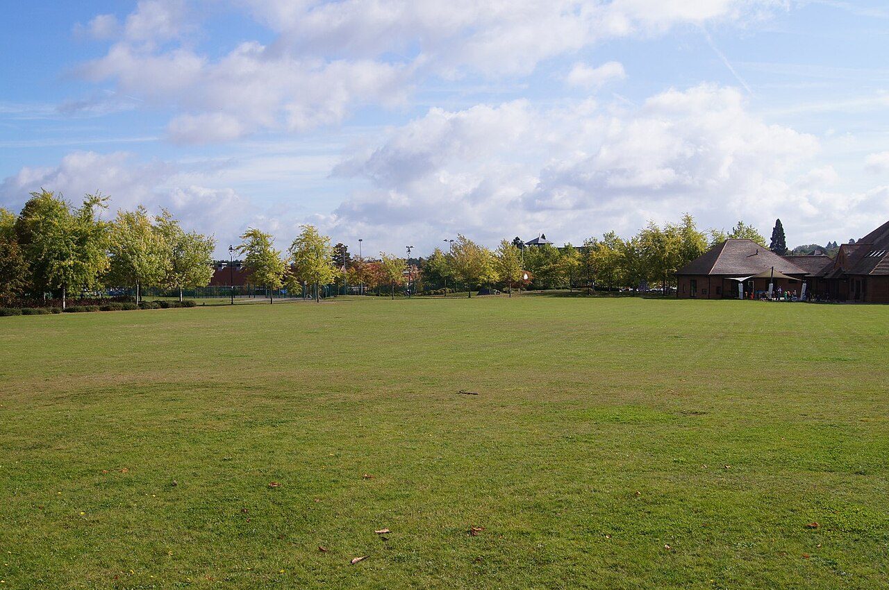
View from Elvetham CrescentPhoto: Mr Ignavy · CC BY-SA 2.0
A−Outdoors Grade
Outdoors in Elvetham Heath · parks, paths & countryside

Almost everyone in Elvetham Heath lives within a 5-minute walk of a park

Parks and playing fields in Elvetham Heath add up to 8.7 ha for every 1,000 residents; the typical UK town has 2.1. The Surrey Hills National Landscape begins 6.1 mi from the town’s edge. 29 km of footpaths run through the town and the kilometre around it, 2.8 for every square kilometre. Elvetham Heath grades A− for the outdoors: #39 of 76 in Hampshire. A character grade: it isn’t part of the overall grade.

Green space
8.7 ha
per 1,000 residents
Typical UK town 2.1
Near a park
100%
of residents within 400 m
Typical UK town 83%
Footpaths
29 km
2.8 km per km², town + 1 km
Typical UK town 3.0 per km²
Protected landscape
0%
of the land within 5 km
Surrey Hills starts 6.1 mi out, past the 5 km
Character

What kind of outdoors town is Elvetham Heath?

Read from the data: what stands out first, good and bad.

Elvetham Heath’s strongest suit is parks close to every home, followed by plenty of park space.

Outdoors grade

Elvetham Heath grades A− for the outdoors

Each chart is every UK town of 1,000 or more on one measure: the green bar is Elvetham Heath, the dashed line the typical town. The number is the share of towns it beats; the five are averaged and the average ranked again.

A−
Better than 80% of UK towns#39 of 76 in Hampshire · 18th of 60 UK towns its size
Public green space8.7 haper 1,000 residents: parks, gardens, playing fields, play spaces
typical 2.1 ha010+
95out of
100
A park within a walk100%of residents within 400 m (a 5-minute walk)
typical 83%0100+
89out of
100
National Park or National Landscape0%of the land within 5 km · Surrey Hills begins just past 5 km
none100+
31out of
100
Footpaths2.8 kmper km², the town and 1 km around it
typical 3.0 km010+
53out of
100
The sea0%of the area within 5 km · Inland
none80+
42out of
100

Graded, never part of the overall grade (like History and Civic life). It measures what is mapped: OS Open Greenspace leaves out woodland and open-access land that isn’t a park, and OpenStreetMap’s rural paths are more complete in some places than others.

Towns its size

Elvetham Heath is 18th of 60 UK towns its size for the outdoors

The 60 UK towns and cities of 4,700 to 5,100 people with an Outdoors Grade. Hover a dot for its figures; tap one for its page.

0255075100Shotton Colliery (County Durham): D− · 0.9 ha green space per 1,000 · 40% near a park · 1.5 km path per km²Bulford (Wiltshire): D− · 0.9 ha green space per 1,000 · 51% near a park · 1.6 km path per km²Wingate (County Durham): D− · 1 ha green space per 1,000 · 64% near a park · 1.5 km path per km²Lepton (West Yorkshire): D− · 0.9 ha green space per 1,000 · 36% near a park · 2.3 km path per km²Fleckney (Leicestershire): D · 0.8 ha green space per 1,000 · 63% near a park · 2.3 km path per km²Melbourn (Cambridgeshire): D · 1.2 ha green space per 1,000 · 45% near a park · 2.7 km path per km²South Cave (East Riding of Yorkshire): D · 1.5 ha green space per 1,000 · 43% near a park · 0.9 km path per km²Gresford (Clwyd): D · 1.4 ha green space per 1,000 · 76% near a park · 1.8 km path per km²Haslington (Cheshire): D · 1.8 ha green space per 1,000 · 41% near a park · 2.6 km path per km²Tickhill (South Yorkshire): D · 1.7 ha green space per 1,000 · 69% near a park · 2.2 km path per km²Halesworth (Suffolk): C− · 1.4 ha green space per 1,000 · 55% near a park · 1.9 km path per km²Melbourne (Derbyshire): C− · 1.5 ha green space per 1,000 · 67% near a park · 2.7 km path per km²Shavington (Cheshire): C− · 1.1 ha green space per 1,000 · 87% near a park · 2.1 km path per km²Northway (Gloucestershire): C · 0.9 ha green space per 1,000 · 58% near a park · 3.1 km path per km²Sutton on Sea and Trusthorpe (Lincolnshire): C · 1.8 ha green space per 1,000 · 67% near a park · 1.5 km path per km²Bungay (Suffolk): C · 0.5 ha green space per 1,000 · 78% near a park · 2.6 km path per km²Bowburn (County Durham): C · 1.5 ha green space per 1,000 · 71% near a park · 3.8 km path per km²Copthorne (West Sussex): C · 1.2 ha green space per 1,000 · 62% near a park · 2.9 km path per km²Treharris (Mid Glamorgan): C · 2.6 ha green space per 1,000 · 72% near a park · 2.6 km path per km²Datchet (Berkshire): C · 8.4 ha green space per 1,000 · 72% near a park · 1.5 km path per km²Billinge (Merseyside): C · 0.9 ha green space per 1,000 · 94% near a park · 3 km path per km²Shortstown (Bedfordshire): C · 2.4 ha green space per 1,000 · 82% near a park · 2.5 km path per km²Church (Lancashire): C · 1.5 ha green space per 1,000 · 79% near a park · 3.9 km path per km²Barton-le-Clay (Bedfordshire): C+ · 1.3 ha green space per 1,000 · 43% near a park · 3.2 km path per km²Moulton (Northamptonshire): C+ · 3.3 ha green space per 1,000 · 88% near a park · 1.7 km path per km²Steeton (West Yorkshire): C+ · 1.3 ha green space per 1,000 · 100% near a park · 2.7 km path per km²Cross Hills (North Yorkshire): C+ · 1.9 ha green space per 1,000 · 86% near a park · 3 km path per km²Stokesley (North Yorkshire): C+ · 0.9 ha green space per 1,000 · 100% near a park · 1.7 km path per km²Wotton-under-Edge (Gloucestershire): C+ · 0.4 ha green space per 1,000 · 32% near a park · 5.4 km path per km²Dickens Heath (West Midlands): C+ · 3.2 ha green space per 1,000 · 82% near a park · 2.5 km path per km²Dudley (Tyne and Wear): C+ · 2.6 ha green space per 1,000 · 69% near a park · 4 km path per km²Handsacre and Armitage (Staffordshire): B− · 1.8 ha green space per 1,000 · 89% near a park · 2.1 km path per km²Headley Down and Headley (Hampshire): B · 2.1 ha green space per 1,000 · 55% near a park · 3.4 km path per km²Sedgefield (County Durham): B · 6.2 ha green space per 1,000 · 81% near a park · 2.8 km path per km²Market Rasen (Lincolnshire): B · 2.6 ha green space per 1,000 · 94% near a park · 1.6 km path per km²Easingwold (North Yorkshire): B · 4.3 ha green space per 1,000 · 86% near a park · 1.5 km path per km²Aspull (Greater Manchester): B · 7.6 ha green space per 1,000 · 92% near a park · 2.4 km path per km²Stone Cross (East Sussex): B+ · 1.4 ha green space per 1,000 · 86% near a park · 2.3 km path per km²Sturry (Kent): B+ · 2.7 ha green space per 1,000 · 80% near a park · 3.4 km path per km²Hildenborough (Kent): B+ · 6.5 ha green space per 1,000 · 40% near a park · 2.8 km path per km²Cranbrook (Devon): B+ · 6.4 ha green space per 1,000 · 87% near a park · 1.9 km path per km²Binfield (Berkshire): A− · 8.5 ha green space per 1,000 · 100% near a park · 2.5 km path per km²Elvetham Heath (Hampshire): A− · 8.7 ha green space per 1,000 · 100% near a park · 2.8 km path per km²Coleford (Gloucestershire): A− · 2.8 ha green space per 1,000 · 66% near a park · 4.3 km path per km²Fordingbridge (Hampshire): A− · 3.6 ha green space per 1,000 · 92% near a park · 2 km path per km²Joyden's Wood (Kent): A− · 2.7 ha green space per 1,000 · 82% near a park · 5.6 km path per km²Fitzwilliam and Kinsley (West Yorkshire): A− · 11.5 ha green space per 1,000 · 100% near a park · 3 km path per km²Rudheath (Cheshire): A · 5.5 ha green space per 1,000 · 100% near a park · 3.7 km path per km²Holmfirth (West Yorkshire): A · 2.2 ha green space per 1,000 · 88% near a park · 4.6 km path per km²Meols (Merseyside): A · 3.1 ha green space per 1,000 · 100% near a park · 2.2 km path per km²Rhymney (Gwent): A · 2.9 ha green space per 1,000 · 97% near a park · 3.8 km path per km²Wirksworth (Derbyshire): A · 2 ha green space per 1,000 · 100% near a park · 4.6 km path per km²Moreton-in-Marsh (Gloucestershire): A · 5 ha green space per 1,000 · 100% near a park · 1.8 km path per km²Wilford (Nottinghamshire): A · 7.7 ha green space per 1,000 · 93% near a park · 9.6 km path per km²Burry Port (Dyfed): A+ · 11.8 ha green space per 1,000 · 75% near a park · 2.8 km path per km²Rownhams and Nursling (Hampshire): A+ · 4.9 ha green space per 1,000 · 86% near a park · 6.7 km path per km²Windermere (Cumbria): A+ · 3 ha green space per 1,000 · 94% near a park · 3.6 km path per km²Frinton-on-Sea (Essex): A+ · 7.5 ha green space per 1,000 · 100% near a park · 2.6 km path per km²Pill (Somerset): A+ · 5.2 ha green space per 1,000 · 100% near a park · 3.8 km path per km²Rye (East Sussex): A+ · 3.5 ha green space per 1,000 · 89% near a park · 3.5 km path per km²Elvetham Heath
Outdoors score: the share of UK towns each one beats
Footpath, km per km²
Elvetham Heath2.8
Towns its size2.6
Hampshire towns3.3
All UK towns3.0
Green space, ha per 1,000 residents
Elvetham Heath8.7
Towns its size2.3
Hampshire towns2.8
All UK towns2.1
Residents within 400 m of a park
Elvetham Heath100%
Towns its size82%
Hampshire towns80%
All UK towns83%

Against towns its size, Elvetham Heath stands out most for park space per resident: only 2 of the other 59 have more.

Show as a table
TownOutdoorsGreen spaceNear a parkPath per km²Protected
1Rye East SussexA+3.589%3.546%
2Pill SomersetA+5.2100%3.80%
3Frinton-on-Sea EssexA+7.5100%2.60%
4Windermere CumbriaA+394%3.6100%
5Burry Port DyfedA+11.875%2.817%
6Rownhams and Nursling HampshireA+4.986%6.712%
7Wilford NottinghamshireA7.793%9.60%
8Moreton-in-Marsh GloucestershireA5100%1.855%
9Wirksworth DerbyshireA2100%4.68%
10Rhymney GwentA2.997%3.86%
11Meols MerseysideA3.1100%2.20%
12Holmfirth West YorkshireA2.288%4.627%
13Rudheath CheshireA5.5100%3.70%
14Fitzwilliam and Kinsley West YorkshireA−11.5100%30%
15Joyden's Wood KentA−2.782%5.64%
16Fordingbridge HampshireA−3.692%256%
17Coleford GloucestershireA−2.866%4.348%
18Elvetham Heath HampshireA−8.7100%2.80%
19Binfield BerkshireA−8.5100%2.50%
20Cranbrook DevonB+6.487%1.91%
21Hildenborough KentB+6.540%2.846%
22Sturry KentB+2.780%3.41%
23Stone Cross East SussexB+1.486%2.39%
24Aspull Greater ManchesterB7.692%2.40%
25Easingwold North YorkshireB4.386%1.514%
26Market Rasen LincolnshireB2.694%1.616%
27Sedgefield County DurhamB6.281%2.80%
28Headley Down and Headley HampshireB2.155%3.444%
29Handsacre and Armitage StaffordshireB−1.889%2.112%
30Dudley Tyne and WearC+2.669%40%
31Dickens Heath West MidlandsC+3.282%2.50%
32Wotton-under-Edge GloucestershireC+0.432%5.460%
33Stokesley North YorkshireC+0.9100%1.716%
34Cross Hills North YorkshireC+1.986%30%
35Steeton West YorkshireC+1.3100%2.70%
36Moulton NorthamptonshireC+3.388%1.70%
37Barton-le-Clay BedfordshireC+1.343%3.238%
38Church LancashireC1.579%3.90%
39Shortstown BedfordshireC2.482%2.50%
40Billinge MerseysideC0.994%30%
41Datchet BerkshireC8.472%1.50%
42Treharris Mid GlamorganC2.672%2.60%
43Copthorne West SussexC1.262%2.913%
44Bowburn County DurhamC1.571%3.80%
45Bungay SuffolkC0.578%2.612%
46Sutton on Sea and Trusthorpe LincolnshireC1.867%1.50%
47Northway GloucestershireC0.958%3.113%
48Shavington CheshireC−1.187%2.10%
49Melbourne DerbyshireC−1.567%2.70%
50Halesworth SuffolkC−1.455%1.95%
51Tickhill South YorkshireD1.769%2.20%
52Haslington CheshireD1.841%2.60%
53Gresford ClwydD1.476%1.80%
54South Cave East Riding of YorkshireD1.543%0.90%
55Melbourn CambridgeshireD1.245%2.70%
56Fleckney LeicestershireD0.863%2.30%
57Lepton West YorkshireD−0.936%2.30%
58Wingate County DurhamD−164%1.50%
59Bulford WiltshireD−0.951%1.60%
60Shotton Colliery County DurhamD−0.940%1.50%
The map

Parks, footpaths & countryside

Tap a number to zoom to a park. Tap a layer to hide it. The dashed line is Elvetham Heath’s built-up area.

1
Green space: parks, gardens, playing fields and play spaces, named or not.© OpenStreetMap contributors · Contains OS data © Crown copyright · Natural England / NRW
Places to walk

Parks to walk in, in and around Elvetham Heath

The biggest is Edenbrook Country Park, 33 ha (81 acres). Directions go to the park’s nearest public entrance where Ordnance Survey maps one.

Elvetham Heath’s biggest

Edenbrook Country Park

Park or garden · 120 m outside town
33 ha (81 acres)6.5 km of path
1 h 25 minto walk all 6.5 km of path
46 pitchesfootball pitches would fit
0.8 mi south-westfrom the centre
Picnic siteEdenbrook Country ParkPush Up
Directionsto the nearest entrance
Close to home

How close Elvetham Heath’s homes are to a park

Each square is 1 in 100 residents: green lives within 400 m of a public park, garden or playing field (Census 2021 output areas against OS Open Greenspace).

Within 400 m (100%)Further (0%)
Elvetham Heath100%
Towns its size82%
Hampshire towns80%
All UK towns83%

Playing fields count, so a park within reach isn’t always one with paths or trees; 29 playgrounds are mapped in and around the town, about one for every 170 residents.

National Parks & National Landscapes

The Surrey Hills National Landscape is 6.1 mi away

Protected landscapes within 30 km, by direction and distance from the edge of the built-up area; circle size shows each one’s area. National Landscapes were called Areas of Outstanding Natural Beauty until 2023.

3.8 mi7.5 mi11.3 mi15 miNSurrey Hills6.1 mi south-eastSurrey Hills National Landscape: 6.1 mi south-east of Elvetham Heath’s edge · 422 km² · since 1958South Downs6.6 mi southSouth Downs National Park: 6.6 mi south of Elvetham Heath’s edge · 1,653 km² · since 2010North Wessex Downs12 mi westNorth Wessex Downs National Landscape: 12 mi west of Elvetham Heath’s edge · 1,731 km² · since 1972Chilterns14 mi north-westChilterns National Landscape: 14 mi north-west of Elvetham Heath’s edge · 838 km² · since 1990Elvetham Heath
National ParkNational LandscapeThe 5 km the grade counts
National Landscape

Surrey Hills

6.1 mi south-east422 km²since 1958
Official site
National Park

South Downs

6.6 mi south1,653 km²since 2010
Official site
National Landscape

North Wessex Downs

12 mi west1,731 km²since 1972
Official site
National Landscape

Chilterns

14 mi north-west838 km²since 1990
Official site

Protected landscape begins just outside the 5 km ring the Outdoors Grade measures, so Elvetham Heath scores 0% on it even though the Surrey Hills National Landscape is 6.1 mi away. South Downs National Park covers 1,653 km² and has been a National Park since 2010.

Footpaths & waymarked walks

4 waymarked walks pass through or near Elvetham Heath

29 km of footpaths, bridleways and rights of way are mapped in Elvetham Heath and the kilometre around it, 2.8 km for every square kilometre (the typical UK town has 3.0). Bars show each route’s kilometres within 2 km of the town.

RegionalLocal
Basingstoke Canal2.8 km
Fleet Pond Yellow Route2.3 km
Fleet Pond Red Route1.0 km
Three Castles Path0.8 km

2 regional routes pass through, including the Basingstoke Canal and Three Castles Path.

Waymarked walks are OpenStreetMap walking routes. Public rights of way are only as complete as the map in each area.

When to get out

The best walking months in Elvetham Heath: May to September

The town’s 1991–2020 averages (Met Office HadUK-Grid) and the daylight at its latitude. Outlined months have 12½+ hours of daylight, highs of 15 °C or more and little rain for the town.

JanFebMarAprMayJunJulAugSepOctNovDec
Daylight (h)8.39.911.713.815.616.616.114.612.510.68.87.9
High (°C)881114182023221915118
Rain (mm)745246504650505756798374

March is the driest month (46 mm) and July the warmest (highs of 23 °C). Winter days are short, about 8 hours of daylight in December, and 83 mm of rain falls in November, the wettest month. Frost comes on about 51 nights a year. The climate in Elvetham Heath →

Things to do

7 viewpoints, 29 playgrounds and the nearest beaches

Mapped within 2 km of the town in OpenStreetMap, against the typical UK town its size per resident. Named places are listed with directions; unnamed ones are only counted.

The nearest beaches

Elvetham Heath is inland. These are the nearest named beaches, measured from the edge of the town.

Penguin Beach7.4 mi from Elvetham Heath’s edge
Directions
Amity Beach16 mi from Elvetham Heath’s edge
Directions
Hog Hole27 mi from Elvetham Heath’s edge
Directions
The Hollows27 mi from Elvetham Heath’s edge
Directions
Good to know

Check the water before you swim. The Environment Agency tests designated bathing waters from May to September and publishes a rating for each beach.

Every named place, with directions

Viewpoints 7

Lions' View0.9 mi from town
Directions

Plus 6 viewpoints without a name on the map.

Hills and peaks 8

The Mountsin town
Directions
Victoria Hill0.5 mi from town
Directions
Mount Zion0.9 mi from town
Directions

Plus 5 hills and peaks without a name on the map.

Nature reserves 2

Elvetham Heath Local Nature Reserve and Open Spaces25 ha · in town
Directions
Ancells Farm Nature Reserve11 ha · 0.9 mi from town
Directions

Picnic sites 2

Country Park Picnic Site0.5 mi from town
Directions

Plus 1 picnic site without a name on the map.

Playgrounds 29

Sorrel Play Area0.2 mi from town
Directions
Blackthorns Play Area0.5 mi from town
Directions
The Views Play Area0.7 mi from town
Directions
Jubilee Wood and Play Structures0.8 mi from town
Directions
Oakley Park Play Area0.9 mi from town
Directions
Calthorpe Park Play Area0.9 mi from town
Directions
Lea Green play area1.1 mi from town
Directions

Plus 22 playgrounds without a name on the map.

Campsites 1

Little Bramshot Farm1.2 mi from town
Directions

Slipways 1

Barley Mow Slipway1.1 mi from town
Directions
Next door

The outdoors in nearby towns

The nearest towns of 1,000+ within 12 miles. Tap a town for its outdoors page.

ABCDOutdoors Grade
TownOutdoorsGreen space, ha per 1,000Near a parkProtected within 5 km
Elvetham HeathA−8.7100%0%
Fleet 1.5 miB+3.379%0%
Minley 2.3 miB−5.70%0%
Hartley Wintney 2.4 miB+6.182%0%
Yateley 3.2 miA−14.985%0%
Farnborough 3.8 miA4.077%3%
Blackwater 3.9 miB+10.674%0%

Farnborough, 3.8 miles away, grades A, the best next door: 77% of its residents live within 400 m of a park.

Questions about the outdoors in Elvetham Heath

What is the biggest park in Elvetham Heath?

Edenbrook Country Park, 33 ha (81 acres), with 6.5 km of path, just outside the built-up area. 1 named park, garden or playing field is in the town or within 400 m of it.

Is Elvetham Heath near a National Park?

Yes. South Downs National Park begins 6.6 mi south of the town’s edge. It covers 1,653 km² and has been a National Park since 2010. The nearest protected landscape of any kind is the Surrey Hills National Landscape, 6.1 mi away.

What are the best walks near Elvetham Heath?

4 waymarked walking routes pass within 2 km of the town, including the Basingstoke Canal, Fleet Pond Yellow Route and Fleet Pond Red Route. Edenbrook Country Park alone has 6.5 km of path.

What is the nearest beach to Elvetham Heath?

Penguin Beach, 7.4 mi from the edge of the town, then Amity Beach (16 mi). Elvetham Heath itself is inland.

How many people in Elvetham Heath live near a park?

100% of residents live within 400 m, about a 5-minute walk, of a public park, garden or playing field (Census 2021 output areas against OS Open Greenspace). The typical UK town is 83%.

When is the best time of year for walking in Elvetham Heath?

May to September: the longest days, the warmest afternoons and the least rain of the year, from the Met Office 1991–2020 averages.

Is Elvetham Heath good for walking?

About average for paths: 2.8 km of footpath and right of way per square kilometre, more than 53% of UK towns. For park space per person it beats 95% (8.7 ha per 1,000 residents).

How is the Outdoors Grade worked out?

From five measures, each placed among UK towns of 1,000 or more: public green space per resident, the share living near a park, National Park or National Landscape within 5 km, footpaths per square kilometre, and the sea within 5 km. It is a character grade and isn’t part of Elvetham Heath’s overall grade.

Sources

Where Elvetham Heath’s outdoors figures come from

  • Parks and green space: Ordnance Survey OS Open Greenspace (parks and gardens, playing fields, play spaces, and their access points). Contains OS data © Crown copyright and database right 2026, Open Government Licence v3.0.
  • National Parks and National Landscapes: Natural England and Natural Resources Wales boundaries, areas and designation dates, Open Government Licence v3.0.
  • Footpaths, walking routes, beaches and things to do: © OpenStreetMap contributors, Open Database License (ODbL), via Geofabrik, 16 October 2026.
  • Historic parks, listed buildings and monuments: Historic England, National Heritage List for England, Open Government Licence v3.0.
  • Rain and temperature: Met Office HadUK-Grid 1991–2020 averages for the town; daylight calculated from its latitude.
  • The sea: ONS Countries (December 2024) boundaries clipped to mean high water. Residents near a park: ONS Census 2021 output areas.
  • Grade: TownRatings’ Outdoors Grade, ranked against UK towns only.

Contains public sector information licensed under the Open Government Licence v3.0. Contains HM Land Registry data © Crown copyright and database right 2026. Contains OS data © Crown copyright and database right 2026 (ONS boundaries). Northern Ireland: Source: NISRA; contains Land & Property Services data and Ordnance Survey of Northern Ireland information, © Crown copyright, licensed under the Open Government Licence v3.0. Scotland: contains National Records of Scotland data, Registers of Scotland data and SEPA data, © Crown copyright / © SEPA 2025, licensed under the Open Government Licence v3.0.