 I
Church · listed 1962Church of St AndrewPhoto: Geoff Pick · CC BY-SA 2.0
 Ufford Hall · Photo: Kim Fyson · CC BY-SA 2.0
–Not graded
History of Ufford · Historic England
39 listed buildings, 2 of them Grade I
On the Historic England list, all of them stand inside Ufford’s built-up area, 1,434 for every 10,000 residents. Grade II covers 32 of Ufford’s listed buildings. 25% of its homes were built before 1919. We have photos of 4 of its listed buildings.
Listed buildings
39
1,434 per 10,000 residents
Grade I
2
exceptional interest
Grade II*
5
more than special interest
Scheduled monuments
0
nationally important sites
Homes built before 1919
25%
typical UK town 15%
In pictures
Landmarks of Ufford
Tap a photo to step through them full screen.
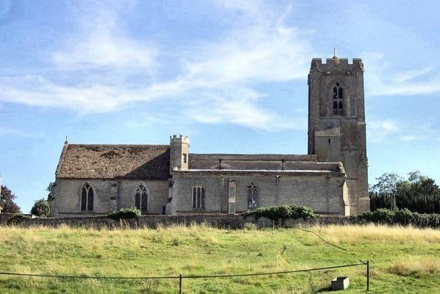 Church of St AndrewGrade I listed
 Flats Nos 1 to 8Grade II* listed
 The Old RectoryGrade II* listed+1See all photos
Photos from Wikimedia Commons and Geograph, copied to our own server, each credited to its photographer with its licence; names open the building’s page or its official list entry.
The map
Where Ufford’s history is
Every Grade I and II* building, monument and historic park.
Grade IGrade II*
Hover a dot for its name; tap one with a photo to open it.
39 listed buildings by grade
2 Grade I5 Grade II*32 Grade II
Historic England lists buildings in three grades: Grade I for buildings of exceptional interest (about 2.5% of all listed buildings), Grade II* for particularly important buildings of more than special interest (about 5.8%), and Grade II for buildings of special interest (about 91.7%). Listing protects the whole building, inside and out.
Every entry on the National Heritage List for England whose point lies inside the ONS 2022 built-up-area boundary. One list entry can cover a terrace or a group of buildings.
Grade I
The 2 Grade I listed buildings in Ufford
Buildings of exceptional interest, about 2.5% of all listed buildings. Every one is photographed. Each opens its own page, with the official list entry.
 I
Public · listed 1962Ufford HallPhoto: Kim Fyson · CC BY-SA 2.0
Grade II*
The 5 Grade II* listed buildings in Ufford
Particularly important buildings of more than special interest. 2 are photographed.
 II*
House · listed 1962Flats Nos 1 to 8Photo: Jonathan Thacker · CC BY-SA 2.0
 II*
House · listed 1962The Old RectoryPhoto: Jonathan Thacker · CC BY-SA 2.0
Public · listed 1962Garden and Boiler Houses Immediately South East of Ufford Hall
Walls & gates · listed 1982Gatepiers and Wall Adjoining South of Stables at Ufford Hall
Walls & gates · listed 1982Wall, Gates and Gatepiers to East of Ufford Hall Between Stables to North and Garden House to South
What’s protected
Most of Ufford’s listed buildings are homes
Every listed building sorted by what its list name says it is.
Houses, terraces & villas28
Walls, gates & bridges6
Public & civic buildings4
Churches, chapels & priories1
28 entries (72%) are houses, terraces and villas. 1 are churches, chapels and priories, including 1 of the 2 Grade I buildings.
Buildings are sorted by words in each entry’s name (church, gate, inn, memorial…): the list’s open data has no building type. An entry named only by its address counts as a house.
Grade II
32 Grade II listed buildings
Most listed buildings are in this grade, which covers buildings of special interest. Open any building to read its official list entry.
All 32 Grade II listed buildings, A to Z
Archway South of Gateway to Ufford HallBarn and Stables North North East of Compass CottageBarn and stable range to south-east of Walnut Tree HouseBarn to South West of Poplar FarmhouseBarn, Stables, Dovecot and Adjoining Walls, South South West of the Old RectoryClarendon CottageCompass CottageDovecot South South East of the RoostDovecot to East of Dovecote CottageDovecote CottageGarden Wall to South West of the Old Rectory, Forming North, South and West Sides of a RectangleGateway to Ufford HallHill CrestHilltop Cottage and Wings to North WestHouse Occupied by Mr FaulknerLaundry CottagePeartreesPoplar FarmhouseSmithy to North East of No 3Stables Immediately East of the RoostStables Immediately North North West of House Occupied by Mr FaulknerStables Immediately North of Clarendon CottageStables Immediately North of Ye Olde White HartStables to South East of the Old RectoryThe RoostTwo Barns to South East of the RoostWall Fronting Road to East of Laundry Cottage Between Garden House and Laundary CottageWalls to Ufford Hall Enclosing Rectangular Kitchen Garden to North of Stables (East Wall Fronting Onto Road)Walnut Tree HouseWoodlands CottageYe Olde White Hart3, Main Street
Conservation areas
1 conservation area covers 58% of Ufford
Areas the council protects as a whole: demolition and changes to how buildings look need consent, and trees are protected.
Ufford 197514 ha
14 hain conservation areas, of 25 ha inside the built-up area.
39 of the 39 listed buildings stand in one.
Historic England’s conservation areas layer, supplied by councils (incomplete in places, so a page fact, never graded). Hectares are the part of each area inside the built-up area.
How the list grew
More than half of Ufford’s listed buildings were added in one year, 1982
The year each building now on the list was first listed.
1982 · 201962 · 19
19501960197019801990200020102020
The first 19 entries were listed in 1962, 2 of the 2 Grade I buildings among them. 20 came in 1982, in the national resurvey of the 1970s and 80s. Only 0 have been added in the last 15 years.
Homes by age
25% of Ufford’s homes were built before 1919
Every home by when it was built, from council tax records, against England & Wales (the dark tick).
24%
Before 1900
0.9%
1900–18
3.6%
1919–29
2.7%
1930s
6.4%
1945–54
13%
1955–64
10%
1965–72
4.5%
1973–82
3.6%
1983–92
7.3%
1993–99
10%
2000–08
7.3%
2009–15
7.3%
2016–25
UffordEngland & Wales
24% of homes are Victorian or older, against 16% across England and Wales. The busiest period since was 1955–64, which added 13% of today’s homes.
Valuation Office Agency, council tax stock of properties by build period, 31 March 2025, for the neighbourhoods (LSOAs) that make up the town, split by where their residents live. Homes with no recorded build period (2 here) are left out; 1939–44 is not a period in the data.
Neighbours
Listed buildings in the places around Ufford
| Town | People | Listed | Grade I | History |
|---|---|---|---|---|
| Ufford | 272 | 39 | 2 | — |
| Barnack | 1,007 | 56 | 1 | A |
| Helpston | 1,249 | 56 | 1 | A |
| Wittering | 2,678 | 9 | 1 | C− |
| Castor and Ailsworth | 1,461 | 82 | 1 | A |
| Glinton | 1,743 | 31 | 1 | B |
| Northborough | 1,336 | 28 | 3 | B+ |
| Market Deeping | 6,533 | 79 | 2 | B |
In brief
Ufford in brief
More of Ufford’s homes are old than in most places: 25% were built before 1919, against 15% in the typical UK town. All told, the list holds 39 listed buildings, 2 of them Grade I. A conservation area has protected part of it since 1975. Most entries on the list, 72%, are houses, terraces and villas. The big year was 1982, when 20 of the 39 went on the list.
Questions about Ufford’s history
How many listed buildings are there in Ufford?
Historic England lists 39 buildings inside Ufford’s built-up area: 2 Grade I, 5 Grade II* and 32 Grade II.
What are the Grade I listed buildings in Ufford?
2, including Church of St Andrew and Ufford Hall.
How many conservation areas are there in Ufford?
1, covering about 14 hectares of the town. The largest is Ufford.
When were Ufford’s buildings listed?
The first in 1962; the most, 20, in 1982.
How old are the homes in Ufford?
25% of homes were built before 1919 and 31% before 1940, from the Valuation Office Agency’s council tax records (March 2025).
Ufford has no History Grade.
© Historic England 2026. Contains Ordnance Survey data © Crown copyright and database right 2026. The National Heritage List for England is the official, up-to-date register of all nationally protected historic buildings and sites in England; check an entry on Historic England’s website before relying on it.
Sources: Historic England, National Heritage List for England (listed buildings, scheduled monuments, registered parks and gardens, battlefields, World Heritage Sites), October 2026, inside the ONS 2022 built-up-area boundary · Valuation Office Agency, Council Tax: stock of properties by build period (31 March 2025) · TownRatings grades: our own summary of the data, ranked against UK towns only · Historic England conservation areas (supplied by local planning authorities; October 2026). All under the Open Government Licence v3.0.
Contains public sector information licensed under the Open Government Licence v3.0. Contains HM Land Registry data © Crown copyright and database right 2026. Contains OS data © Crown copyright and database right 2026 (ONS boundaries). Northern Ireland: Source: NISRA; contains Land & Property Services data and Ordnance Survey of Northern Ireland information, © Crown copyright, licensed under the Open Government Licence v3.0. Scotland: contains National Records of Scotland data, Registers of Scotland data and SEPA data, © Crown copyright / © SEPA 2025, licensed under the Open Government Licence v3.0.