Pleasant Hill dates to 1819, and 1 of its places is on the National Register
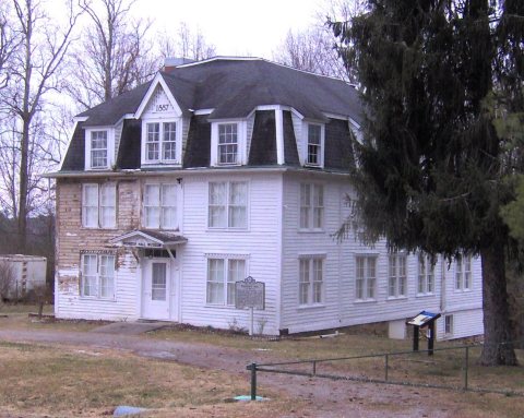
Most of Pleasant Hill was built recently: 8% of its homes predate 1940 and the median home dates from 1985. Its Register listing is the Pioneer Hall. Below: maps from 1912 on and the census since 1910.
Lost a third of its people between 1910 and 1920, then grew 3-fold.
12 censuses, 1910–2020.
U.S. Census Bureau decennial counts, from the census table on Pleasant Hill’s Wikipedia page.
On the map
Pleasant Hill on the map, 1912 to 1976
Every edition of the U.S. Geological Survey’s map of Pleasant Hill. Tap a year, or press play to watch the town change.
1912Crossville sheet · 1:62,500
U.S. Geological Survey historical topographic maps (public domain), via Esri’s collection of the scans. The red ring marks the center of Pleasant Hill.
Pleasant Hill was first settled by European Americans before 1819. In 1884 a teacher from the American Missionary Association (AMA) established the Pleasant Hill Academy to provide broad liberal arts education for rural youth, while also giving vocational training in agriculture and local skills. Supported by the Congregational Church, the school operated until 1947. Its main building, Pioneer Hall, is still standing.
May Cravath Wharton, an early woman physician from Minnesota, established a medical clinic at the academy, where her husband was the director. Wharton also cared for people in the community. They invited her to stay after the death of her husband Edwin.
Founding dates: Wikidata, Wikipedia, the U.S. post office records of Blevins & Helbock (CC0) and the Census. Homes by year built: Census ACS 2020–24. National Register of Historic Places: National Park Service (list of May 22, 2026). Old photos, postcards and papers: Wikimedia Commons, the Library of Congress and other public archives, credited on each item’s page. Maps: U.S. Geological Survey historical topographic maps (via Esri) and Sanborn fire-insurance maps (Library of Congress). History text and census tables: Wikipedia (CC BY-SA 4.0). Places that used to be: USGS Geographic Names Information System (2021). How TownRatings grades history →
From Wikimedia Commons (4), Wikidata (1), the National Register of Historic Places (1), Wikipedia, U.S. Geological Survey historical maps, U.S. Census counts (via Wikipedia), the US Post Offices dataset (Blevins & Helbock) and the USGS Geographic Names Information System. Archive images are copied here with their credits and licenses, shown on each photo’s page. Refreshed monthly.


 2015
 2015
 2015
 2010


