Liberty was settled circa 1797 by Adam Dale, an American Revolutionary War veteran from Maryland who built a mill on Smith Fork Creek.
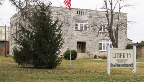
Much of Main Street in Liberty is included in an historic district listed on the National Register of Historic Places. Properties in the historic district include the Liberty High School, built from limestone quarried in the area, and the Salem Baptist Church and cemetery.
On the evening of March 23, 1889, Liberty was hit by a tornado that uprooted trees and caused extensive damage to homes. A local church was completely destroyed. According to records, there were no fatalities reported.
Passages that mention Liberty, cut from the printed page as they were published.
History of DeKalb county, Tennessee1915 · page 67Read the page →
Read the text
It is probable that the earliest church in DeKalb County was erected by the Baptists of Liberty. In Grime's history of Middle Tennessee Baptists it is said that Cantrell Bethel, born in Maryland December 17' I779> and died near Liberty October- 22, 1848.
Text read by machine from the scan; it may contain errors.
History of DeKalb county, Tennessee1915 · page 32Read the page →
Read the text
Liberty was incorporated January 17, 1850. The boundaries were: Beginning at a sour oak near Leonard Lamberson's wellspring, thence south to Smith's Fork, thence down said creek with its meanders to the mouth of the branch west of the town spring, thence west to a chinquapin oak standing on the north side of the Liberty and Dismal Creek road, 32
Text read by machine from the scan; it may contain errors.
Scans and text from the Internet Archive. Books published in 1930 or earlier, which are in the public domain.
Founding dates: Wikidata, Wikipedia, the U.S. post office records of Blevins & Helbock (CC0) and the Census. Homes by year built: Census ACS 2020–24. National Register of Historic Places: National Park Service (list of May 22, 2026). Old photos, postcards and papers: Wikimedia Commons, the Library of Congress and other public archives, credited on each item’s page. Maps: U.S. Geological Survey historical topographic maps (via Esri) and Sanborn fire-insurance maps (Library of Congress). History text and census tables: Wikipedia (CC BY-SA 4.0). Places that used to be: USGS Geographic Names Information System (2021). How TownRatings grades history →
From the Library of Congress (1), the National Register of Historic Places (1), Wikipedia, Wikidata and Wikipedia for famous people, the US Post Offices dataset (Blevins & Helbock), the USGS Geographic Names Information System and old county and town histories (Internet Archive). Archive images are copied here with their credits and licenses, shown on each photo’s page. Refreshed monthly.



 Date?