25 of Orangeburg’s places are on the National Register
More historic than 66% of U.S. towns · #45 of 169 in South Carolina. What drives it
Most of Orangeburg was built recently: 4% of its homes predate 1940 and the median home dates from 1968. Below: 12 old photos and papers, maps from 1884 on, and the census since 1860.
On its age, its old homes and the National Register, Orangeburg is more historic than 66% of U.S. towns, #45 of 169 in South Carolina. Its National Register listings hold the grade up; its share of homes from before 1940 pulls it down.
B+
HistoryA character grade: shown, never part of Orangeburg’s overall grade.
South Carolina towns list more on the Register than most of the country (a typical South Carolina town has 3.2 per 10,000 residents, the U.S. 2.4), so Orangeburg’s 155 sits above most of its state (88% of South Carolina towns have fewer) while its 206 historic buildings outnumber those of 93% of U.S. towns.
How sure. Graded on two of the three inputs, so a change in either one moves the letter more than it would with three. The pre-1940 share (±2.3 points) is firm at this size.
Founding year: our sources. Homes: Census ACS 2020–24. National Register: National Park Service, May 2026 list; each listing counted once (boundary changes and added documentation belong to their listing), and a historic district counts its contributing buildings. How TownRatings grades history →
What stands out about Orangeburg’s past
Read from the archive, the National Register and the record. The page puts what stands out first.
A J Thackston High SchoolschoolChrist the King Roman Catholic ChurchchurchChurch of GodchurchDunton Memorial SchoolschoolFelton Training SchoolschoolGlorious Holiness ChurchchurchRiverside SchoolschoolSanctified ChurchchurchShiloh Baptist ChurchchurchStiles R Mellichamp Graded SchoolschoolTemple SinaichurchTri-County Hospitalhospital
4cemeteries and burying grounds inside Orangeburg
First BaptistMemorial ParkOrangeburg MemorialSunnyside
US Post Offices dataset (Blevins & Helbock, CC0). Places and cemeteries from the USGS Geographic Names Information System (2021).
People over time
Orangeburg, census by census
Lost two-thirds of its people between 1860 and 1870, then grew more than tenfold.
17 censuses, 1860–2020.
U.S. Census Bureau decennial counts, from the census table on Orangeburg’s Wikipedia page.
European settlement in this area started in 1704 when George Sterling set up a post here for fur trade with Native Americans. To encourage settlement, the General Assembly of the Province of South Carolina in 1730 organized the area as a township, naming it Orangeburg for William IV, Prince of Orange, the son-in-law of King George II of Great Britain. In 1735, a colony of 200 Swiss, German and Dutch immigrants formed a community near the banks of the North Edisto River. The site was attractive because of the fertile soil and the abundance of wildlife. The river provided the all-important transportation waterway to the port of Charleston on the Atlantic coast for the area's agriculture and lumber products, and for shipping goods upriver. The town soon became a well-established and successful colony, composed chiefly of small yeomen farmers.
Passages that mention Orangeburg, cut from the printed page as they were published.
The history of Orangeburg County, South Carolina1898 · page 30Read the page →
Read the text
Probably the first settler in the vicinity of where the present town of Orangeburg is located was John Hearn, (pronounced Harn) w ho lived just below where Orangeburg now stands as early as 1782. His plantation contained five hundred acres of land and embraced lands now or lately belonging to Messrs John H. Dukes, A. L. Dukes, G. W. Brunson, and Mrs. Mary Hughes. The following certificate of admeasurement,
Text read by machine from the scan; it may contain errors.
The history of Orangeburg County, South Carolina1898 · page 70Read the page →
Read the text
"In Mills' Statistics of South Carolina, page 611, we have the following statement in reference to Lexington District (now County): 'This District, when first settle'l, was merged in Orangeburg precincts. A parish and township were laid out in about the year 1750. and named Saxe-Gotha, in compliment to the first settlers of the country, who came from that part of Germany.'
Text read by machine from the scan; it may contain errors.
The history of Orangeburg County, South Carolina1898 · page 73Read the page →
Read the text
“Orangeburg, South Carolina, was settled by Germans in 1735; Saxe-Gotha, further inland, of necessity was settled still later; hence common sense will admit of no date of permanent settlement earlier than, or even as early as, that period of time.
Text read by machine from the scan; it may contain errors.
The history of Orangeburg County, South Carolina1898 · page 46Read the page →
Read the text
pastors, Bolzius and Gronan, found in Xh'lsperger's Nachrichten: 'Their journal of that time mentions among other things, that many Lutherans were settled in and about Orangeburg in South Carolina, and that their preacher resided in the village of Orangeburg.'
Text read by machine from the scan; it may contain errors.
Scans and text from the Internet Archive. Books published in 1930 or earlier, which are in the public domain.
Timeline
Orangeburg, 1794 to 1980
Woven from the archive, old maps, post office records, the National Register and the people born here.
Nothing in the archives for these yearsWeddings on Main Street, storms, parades, school pictures, the old store. If it’s in your family album, it belongs here.
Every edition of the U.S. Geological Survey’s map of Orangeburg. Tap a year, or press play to watch the town change.
1943Orangeburg sheet · 1:62,500
U.S. Geological Survey historical topographic maps (public domain), via Esri’s collection of the scans. The red ring marks the center of Orangeburg.
Every building
Orangeburg, building by building, 1884–1922
Fire insurance maps drew every building, what it was made of and what it was used for, so insurers could price the risk of fire. Pick a year, then a sheet.
1884Sheet 1 of 1
Edition
Sheets
BrickWoodStone
Sanborn Map Company, via the Library of Congress. Editions published in 1930 or earlier, which are in the public domain.
Then & now
Stand where they stood
No then-and-now pairs yet. Take a photo from the same spot as an old one and they appear here side by side.
Retake this viewBricklaying at Claflin University, Orangeburg, S.C, 1899
Find the spot, match the angle, and add your photo. It becomes the first then-and-now pair on Orangeburg’s page.
Orangeburg is more historic than 66% of U.S. towns, #45 of 169 in South Carolina. The History grade combines the town’s founding era, the share of homes built before 1940 and its National Register listings. It’s a character grade, so it isn’t part of the overall grade. How it works.
What is on the National Register in Orangeburg?
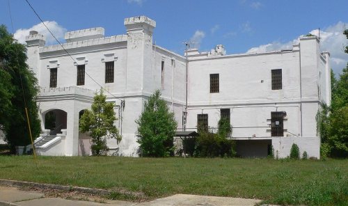
25 listings: 16 buildings, among them the Orangeburg County Jail (listed 1973, the first), 8 historic districts with 187 contributing buildings, and 1 site. 206 historic buildings in all.
How old are the homes in Orangeburg?
4% of Orangeburg’s homes were built before 1940 (Census estimate, ±2.3 points), against a typical 3.5% for a South Carolina town; the median home was built in 1968.
Founding dates: Wikidata, Wikipedia, the U.S. post office records of Blevins & Helbock (CC0) and the Census. Homes by year built: Census ACS 2020–24. National Register of Historic Places: National Park Service (list of May 22, 2026). Old photos, postcards and papers: Wikimedia Commons, the Library of Congress and other public archives, credited on each item’s page. Maps: U.S. Geological Survey historical topographic maps (via Esri) and Sanborn fire-insurance maps (Library of Congress). History text and census tables: Wikipedia (CC BY-SA 4.0). Places that used to be: USGS Geographic Names Information System (2021).
From Wikimedia Commons (6), the Library of Congress (6), the National Register of Historic Places (25), Wikipedia, Wikidata and Wikipedia for famous people, U.S. Geological Survey historical maps, U.S. Census counts (via Wikipedia), the US Post Offices dataset (Blevins & Helbock), the USGS Geographic Names Information System, Sanborn fire insurance maps (Library of Congress) and old county and town histories (Internet Archive). Archive images are copied here with their credits and licenses, shown on each photo’s page. Refreshed monthly.





 1899
 1899
 1899
 1899
 1899
 1899
 1899
 1899
 1899
 1899
 1899


