Marion dates to 1795, and 18% of its homes were built before 1940
More historic than 90% of U.S. towns · #7 of 169 in South Carolina. What drives it
2 places in town are on the National Register, among them a historic district with 109 buildings. Below: 12 old photos and papers, maps from 1884 on, and the census since 1850.
Founding year: Wikidata. First post office: 1808.The full story ↓
History grade
What drives Marion’s History grade
On its age, its old homes and the National Register, Marion is more historic than 90% of U.S. towns, #7 of 169 in South Carolina. All 3 inputs are above most U.S. towns; its National Register listings ranks highest and its share of homes from before 1940 lowest.
A
HistoryA character grade: shown, never part of Marion’s overall grade.
South Carolina towns list more on the Register than most of the country (a typical South Carolina town has 3.2 per 10,000 residents, the U.S. 2.4), so Marion’s 179 sits above most of its state (90% of South Carolina towns have fewer) while its 111 historic buildings outnumber those of 90% of U.S. towns.
How sure. Graded on any two of the three inputs instead, the letter would range from A− to A. The pre-1940 share is a Census survey estimate (±5.7 points). Two sources give 1795.
Founding year: Wikidata (other dates in Quick answers). Homes: Census ACS 2020–24. National Register: National Park Service, May 2026 list; each listing counted once (boundary changes and added documentation belong to their listing), and a historic district counts its contributing buildings. How TownRatings grades history →
What stands out about Marion’s past
Read from the archive, the National Register and the record. The page puts what stands out first.
National Park Service, National Register of Historic Places. Photos from Wikimedia Commons, credited on each place’s page.
Every building
Marion, building by building, 1884–1915
Fire insurance maps drew every building, what it was made of and what it was used for, so insurers could price the risk of fire. Pick a year, then a sheet.
Nothing in the archives for these yearsWeddings on Main Street, storms, parades, school pictures, the old store. If it’s in your family album, it belongs here.
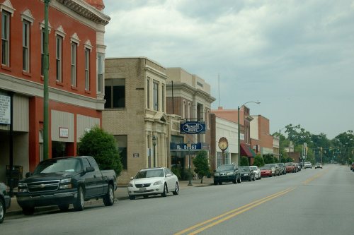
The Marion High School, Marion County Court House, Marion County Library, Marion County Museum and Marion Historic District are listed on the National Register of Historic Places.
Passages that mention Marion, cut from the printed page as they were published.
a history of marion country, south carolina1902 · page 66Read the page →
Read the text
resided near the county seat before the court house was erected ; as we are informed by tradition, Colonel Hugh Giles, a distinguished character during the Revolutionary War, lived just over Smith’s Swamp, south of the site of Marion Court House. It was for him that the village of Marion was first called Gilesboro, and was so called till away up into the thirties, and even after that by some of the older people. The town of Marion was not incorporated until long after. At the time of which
Text read by machine from the scan; it may contain errors.
The minute boys of South Carolina1907 · page 356Read the page →
Read the text
“ In the spring of 1781 Colonel Watson was sent with a select corps of five hundred men to attempt the destruction of Marion’s brigade. The advanced guards of Marion, under Colonel Horry, met the advance of the enemy, and the patriots were obliged to fall back in the direction of Williamsburg. ... For ten days the British force remained stationary, continually annoyed by Marion, until
Text read by machine from the scan; it may contain errors.
a history of marion country, south carolina1902 · page 38Read the page →
Read the text
and industrial enterprise. Much might be said in amplifying the contrast between our conditions educationally now and one hundred years ago, but space will not permit and the field is too large. In 1814, the Marion Academy Society, at Marion Court House, was given the power of escheators and also its perquisites up to $2,000. It seems it had been incorporated before, but the writer has not been able to find the Act of incorporation, and hence he cannot give the names of the corpora-
Text read by machine from the scan; it may contain errors.
A history of Marion county, South Carolina, from its earliest times to the present, 19011902 · page 66Read the page →
Read the text
resided near the county seat before the court house was erected ; as we are informed by tradition, Colonel Hugh Giles, a distinguished character during the Revolutionary War, lived just over Smith's Swamp, south of the site of Marion Court House. It was for him that the village of Marion was first called Gilesboro, and was so called till away up into the thirties, and even after that by some of the older people. The town of Marion was not incorporated until long after. At the time of which
Text read by machine from the scan; it may contain errors.
Scans and text from the Internet Archive. Books published in 1930 or earlier, which are in the public domain.
Timeline
Marion, 1795 to 1984
Woven from the archive, old maps, post office records, the National Register and the people born here.
In 1795, according to Wikidata. Marion’s post office opened in 1808, and the census of 1850 counted 214 people here.
How does Marion rank for history?
Marion is more historic than 90% of U.S. towns, #7 of 169 in South Carolina. The History grade combines the town’s founding era, the share of homes built before 1940 and its National Register listings. It’s a character grade, so it isn’t part of the overall grade. How it works.
What is on the National Register in Marion?
Two places: the Marion Historic District (listed 1973) and the Marion High School (2001).
How old are the homes in Marion?
18% of Marion’s homes were built before 1940 (Census estimate, ±5.7 points), against a typical 3.5% for a South Carolina town; the median home was built in 1963.
Founding dates: Wikidata, Wikipedia, the U.S. post office records of Blevins & Helbock (CC0) and the Census. Homes by year built: Census ACS 2020–24. National Register of Historic Places: National Park Service (list of May 22, 2026). Old photos, postcards and papers: Wikimedia Commons, the Library of Congress and other public archives, credited on each item’s page. Maps: U.S. Geological Survey historical topographic maps (via Esri) and Sanborn fire-insurance maps (Library of Congress). History text and census tables: Wikipedia (CC BY-SA 4.0). Places that used to be: USGS Geographic Names Information System (2021).
From Wikimedia Commons (12), the National Register of Historic Places (2), Wikipedia, Wikidata and Wikipedia for famous people, U.S. Geological Survey historical maps, U.S. Census counts (via Wikipedia), the US Post Offices dataset (Blevins & Helbock), the USGS Geographic Names Information System, Sanborn fire insurance maps (Library of Congress) and old county and town histories (Internet Archive). Archive images are copied here with their credits and licenses, shown on each photo’s page. Refreshed monthly.




 c. 1907
 c. 1909
 c. 1910
 c. 1910
 c. 1910
 c. 1910
 c. 1910
 c. 1910
 1912
 1912
 c. 1915
 c. 1915