Warren dates to 1680, and 45% of its homes were built before 1940
Among the most historic 1% of U.S. towns · #2 of 38 in Rhode Island. What drives it
2 places in town are on the National Register, among them a historic district with 599 buildings. Below: 12 old photos and papers, maps from 1887 on, and the census since 1790.
Founding year: Wikidata. First post office: 1792.The full story ↓
History grade
What drives Warren’s History grade
On its age, its old homes and the National Register, Warren is among the most historic 1% of U.S. towns, #2 of 38 in Rhode Island. All 3 inputs put Warren near the top nationally; its share of homes from before 1940 ranks highest.
A+
HistoryA character grade: shown, never part of Warren’s overall grade.
Rhode Island towns list more on the Register than most of the country (a typical Rhode Island town has 94.7 per 10,000 residents, the U.S. 2.4), so Warren’s 539 sits above most of its state (95% of Rhode Island towns have fewer) while its 601 historic buildings outnumber those of 98% of U.S. towns.
NoteThe founding year comes from Wikidata alone; no second source gives 1680.
How sure. Graded on any two of the three inputs instead, the letter would still be A+. The pre-1940 share is a Census survey estimate (±4.4 points).
Founding year: Wikidata (other dates in Quick answers). Homes: Census ACS 2020–24. National Register: National Park Service, May 2026 list; each listing counted once (boundary changes and added documentation belong to their listing), and a historic district counts its contributing buildings. How TownRatings grades history →
What stands out about Warren’s past
Read from the archive, the National Register and the record. The page puts what stands out first.
Warren was the site of the Pokanoket Indian settlement of Sowams located on a peninsula within the Pokanoket region. The region consisted of over 60 settlements under the authority of Chief Massasoit (sometimes called Osamequin) who controlled the land from Plymouth to the eastern shores of Narragansett Bay. English colonists Edward Winslow and Stephen Hopkins from Plymouth Colony first visited there in July, 1621. Winslow and John Hampden saved Massasoit's life two years later and gained an important ally and lifelong friend. The colonists set up a trading post by 1632 on the banks of the Kickemuit River where they traded English goods for furs and other items. Roger Williams was banished from Salem, Massachusetts, in January, 1636, and fled to Sowams, becoming ill on the way. He was sheltered by Massasoit in Sowams until he recovered over the winter months; he later established Provid…
Passages that mention Warren, cut from the printed page as they were published.
A history of the Fire department of Warren, Rhode Island / by Virginia Baker1912Read the page →
Read the text
work of the fire fighters prevented a very serious conflagration. That their effiDrts were appreciated the following resolution, passed on March 10, amply testifies: — "Resolved that the town of Warren in town meeting assembled hereby acknowledges its indebtedness to the officers and members of the Warren Fire Department for the courageous and efficient manner in which they performed their duty at the fire of March 6, 1888.
Text read by machine from the scan; it may contain errors.
A history of the Fire department of Warren, Rhode Island / by Virginia Baker1912Read the page →
Read the text
upon November 4, the following resolution was passed in town meeting: — "In Town Meeting, November 4, 1856, Resolved unanimously, by the Freemen of the Town of Warren in Town Meeting assembled, that the thanks of the town be presented to the members of King Philip Fire Engine Co.
Text read by machine from the scan; it may contain errors.
The history of Warren, Rhode Island, in the war of the revolution, 1776-17831901 · page 67Read the page →
Read the text
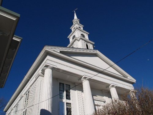
In this meeting-house was held the first commencement of Rhode Island College, now Brown University, which was originally situated in Warren. South of the meeting-house stood the parsonage built by subscription in 1765 and designed for the Rev.
Text read by machine from the scan; it may contain errors.
Scans and text from the Internet Archive. Books published in 1930 or earlier, which are in the public domain.
By decade
Warren, decade by decade
3 decades in the archive, from the 1770s to the 1900s. Scroll each row; tap a photo for its story.
Nothing in the archives for these yearsWeddings on Main Street, storms, parades, school pictures, the old store. If it’s in your family album, it belongs here.
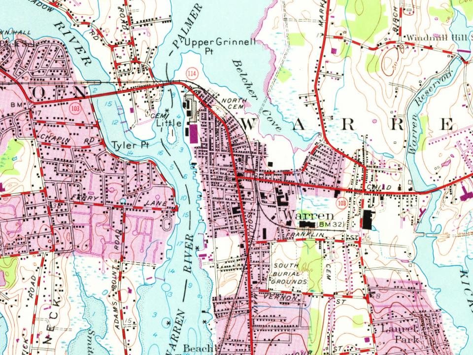
Fire insurance maps drew every building, what it was made of and what it was used for, so insurers could price the risk of fire. Pick a year, then a sheet.
Benjamin Barton LotButterworthCaptain Benjamin Barton LotCaptain Nathan Munro Junior LotDaniel ColeDr Walter Haile LotJames Mason LotJohn Brown LotKickemuitNorthObadiah Bowen LotSaint AlexanderSaint Jean BaptisteSaint Mary of the BaySouth
US Post Offices dataset (Blevins & Helbock, CC0). Places and cemeteries from the USGS Geographic Names Information System (2021).
Help out
Finish Warren’s story
Most archives stop around 1920. The photos from after that are in family albums, not libraries.
Decades since 1900 with photos
00s10s20s30s40s50s60s70s80s90s
1 of 10 decades. The empty ones are waiting for someone’s album.
In 1680, according to Wikidata. Warren’s post office opened in 1792, and the first U.S. census counted 1,122 people here in 1790.
How does Warren rank for history?
Warren is among the most historic 1% of U.S. towns, #2 of 38 in Rhode Island. The History grade combines the town’s founding era, the share of homes built before 1940 and its National Register listings. It’s a character grade, so it isn’t part of the overall grade. How it works.
What is on the National Register in Warren?
Two places: the Warren United Methodist Church and Parsonage (listed 1971) and the Warren Waterfront Historic District (1974).
How old are the homes in Warren?
45% of Warren’s homes were built before 1940 (Census estimate, ±4.4 points), against a typical 20% for a Rhode Island town; the median home was built in 1950.
Founding dates: Wikidata, Wikipedia, the U.S. post office records of Blevins & Helbock (CC0) and the Census. Homes by year built: Census ACS 2020–24. National Register of Historic Places: National Park Service (list of May 22, 2026). Old photos, postcards and papers: Wikimedia Commons, the Library of Congress and other public archives, credited on each item’s page. Maps: U.S. Geological Survey historical topographic maps (via Esri) and Sanborn fire-insurance maps (Library of Congress). History text and census tables: Wikipedia (CC BY-SA 4.0). Places that used to be: USGS Geographic Names Information System (2021).
From Wikimedia Commons (7), the Library of Congress (5), the National Register of Historic Places (2), Wikipedia, Wikidata and Wikipedia for famous people, U.S. Geological Survey historical maps, U.S. Census counts (via Wikipedia), the US Post Offices dataset (Blevins & Helbock), the USGS Geographic Names Information System, Sanborn fire insurance maps (Library of Congress) and old county and town histories (Internet Archive). Archive images are copied here with their credits and licenses, shown on each photo’s page. Refreshed monthly.








 1778
 1909
 1909
 1909
 1909
 1909
 1909
 1909
 1909

