Guest, Sign inJoin

Post to New Shoreham

We’ll email a one-tap link to publish your post. No password, and nothing is public until you click it.
Already a member? Sign in
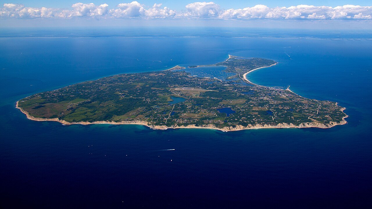
HiRes BlockIsland Aerial 7-23-2015Photo: Timothy J. Quill · CC BY-SA 4.0
A+Outdoors
Outdoors in New Shoreham

38% of New Shoreham’s land is conserved: 2,256 acres

24 miles of mapped trail cross New Shoreham, 2.7 per square mile of land. 319 acres are parks and preserves, 410 per 1,000 residents. The biggest trail networks: Lapham (3.4 mi), Rodman's Hollow (2 mi), Sachem Pond (0.9 mi).

Ahead of 97% of U.S. towns. What drives it

Conserved land
38%
2,256 acres · of 9.1 sq mi of land
Trails
24 mi
2.7 per sq mi of land
Park land
319 ac
410 acres per 1,000 residents
Near a park
68%
of residents within ½ mile
Highest peak
204 ft
Beacon Hill
Lakes & rivers
22
13 beaches

What kind of outdoors town is New Shoreham?

Read from the map. The page puts what stands out first.

Outdoors grade

How much outdoors does New Shoreham have?

On conserved land, trails, park land and how close residents live to a park, New Shoreham is ahead of 97% of U.S. towns. All four inputs are above most U.S. towns; conserved land ranks highest, the share of residents near a park lowest.

A+
OutdoorsA character grade: shown, never part of New Shoreham’s overall grade.
All U.S. towns we grade (21,298)Ahead of 97%
LessMore

Rhode Island towns conserve more land than most (a typical one, 19%; the U.S., 4%), so New Shoreham’s 38% is ahead of 97% of Rhode Island towns, while its trails per square mile lead 92% of them.

Water is more than half of New Shoreham’s area (100 of 110 square miles), so every share here is of land; over land and water together, the conserved share would read 3%.

How sure. Graded on any three of the four inputs instead, the letter would range from A to A+. Trails and many small parks come from OpenStreetMap, mapped by volunteers, so coverage varies from town to town; the half mile is a straight line from each census block, so a river or highway in the way isn’t counted against it.

PAD-US, OpenStreetMap (© OpenStreetMap contributors), Census 2025 Gazetteer and 2020 blocks; details in Sources below. How TownRatings grades the outdoors →

The map

Conserved land, trails & bike routes

Tap a number to zoom to a park. Tap a layer to hide it.

12345678
Easements protect land from building but are usually private.© OpenStreetMap contributors · USGS PAD-US
Places to walk

Pick a walk

The longest trail network is Lapham, with 3.4 miles. Directions go to the nearest trailhead or public parking.

Lapham

Nature preserve
126 acres3.4 mi of trail
Long Lot Trail
Dog rules not recorded
Directionsto the trail sign

Rodman's Hollow

Nature preserve
114 acres2 mi of trail
Dog rules not recorded
No trailhead mapped yet

Sachem Pond

Managed by Town of New Shoreham
130 acres0.9 mi of trail
Dog rules not recorded
Directionsto the parking lot

Clay Head / Lapham

Managed by The Nature Conservancy
13 acres0.9 mi of trail
Dogs usually not allowed
No trailhead mapped yet

West Beach

Managed by Town of New Shoreham
56 acres0.7 mi of trail
Dog rules not recorded
No trailhead mapped yet

Rodman's Hollow Nature Preserve

Nature preserve
50 acres0.7 mi of trail
Dog rules not recorded
No trailhead mapped yet

Lewis / Dickens Farm

Nature preserve
42 acres0.6 mi of trail
Dog rules not recorded
No trailhead mapped yet

Ocean View

Managed by Block Island Land Trust
16 acres0.6 mi of trail
Dog rules not recorded
Directionsto the parking lot
All 52 parks & preserves
Lapham126 acres · 3.4 mi of trail
Directions
Rodman's Hollow114 acres · 2 mi of trail
Sachem Pond130 acres · 0.9 mi of trail · Town of New Shoreham
Directions
Clay Head / Lapham13 acres · 0.9 mi of trail · The Nature Conservancy
West Beach56 acres · 0.7 mi of trail · Town of New Shoreham
Rodman's Hollow Nature Preserve50 acres · 0.7 mi of trail
Lewis / Dickens Farm42 acres · 0.6 mi of trail
Ocean View16 acres · 0.6 mi of trail · Block Island Land Trust
Directions
Block Island National Wildlife Refuge131 acres · 0.4 mi of trail · United States Fish and Wildlife Service
Directions
Fresh Pond24 acres · 0.4 mi of trail
Fresh Swamp32 acres · 0.3 mi of trail
Hemenway27 acres · 0.3 mi of trail
Risom7 acres · 0.3 mi of trail
Nevas Greenberg Trail10 acres · 0.2 mi of trail
Town Beach40 acres · 0.1 mi of trail · Town of New Shoreham
Directions
Mohegan Bluffs28 acres · 0.1 mi of trail · State of Rhode Island Department of Environmental Management
Directions
Hodge Family Wildlife Preserve26 acres · 0.1 mi of trail · The Nature Conservancy
Directions
Gunners Hill9 acres · 0.1 mi of trail · The Nature Conservancy
Mansion Beach8 acres · 0.1 mi of trail · Town of New Shoreham
Wood4 acres · 0.1 mi of trail
Ball O'Brien Park13 acres
Lewis10 acres
Clayhead / Lapham8 acres · The Nature Conservancy
Bonnell Beach7 acres
Indian Head7 acres · Town of New Shoreham
Directions
Mohegan Bluff7 acres · The Nature Conservancy
Directions
Clay Head Swamp6 acres · The Nature Conservancy
Clay Head / Whitman6 acres · Town of New Shoreham
Clayhead / Merck5 acres · The Nature Conservancy
Meadowhill5 acres · Block Island Conservancy
Spring Pond5 acres · Town of New Shoreham
Directions
McCluskey5 acres · Block Island Conservancy
Beach Road5 acres · Block Island Conservancy
Directions
Pinney4 acres · Block Island Conservancy
Nevas-Gree4 acres · The Nature Conservancy
White3 acres · The Nature Conservancy
Directions
John E's Pond3 acres · The Nature Conservancy
Payne Road3 acres · Town of New Shoreham
Directions
North Light3 acres · Town of New Shoreham
Clay Head / Attwood3 acres · Block Island Conservancy
Mohegan Bluff / Payne3 acres · The Nature Conservancy
Directions
Locke2 acres · The Nature Conservancy
Old Harbor2 acres · Town of New Shoreham
Directions
Veterans Park2 acres
Ambrose Swamp / Drazen2 acres · The Nature Conservancy
Carrow-Blane2 acres · The Nature Conservancy
Great Salt Point1 acres · Town of New Shoreham
Murphy1 acres · Block Island Conservancy
Clayhead / Garden Pond1 acres · Block Island Conservancy
Rookery1 acres · Block Island Conservancy
Harbor Pond1 acres · Town of New Shoreham
Directions
Faulkner1 acres · The Nature Conservancy
Directions
Who protects it

2,256 conserved acres

38% of New Shoreham’s land. Water is left out: New Shoreham has 9.1 square miles of land and 100.4 of water, so the share counts land only. Who manages New Shoreham’s conserved land, from the USGS Protected Areas Database. Approximate, because parcels can overlap.

Land trusts & nonprofits1,788 ac
U.S. Fish and Wildlife Service265 ac
State natural resources252 ac
State conservation182 ac
Town or city44 ac
USDA easements (NRCS)43 ac
Joint41 ac
Conservation Easement · 1,242 acPrivate Conservation · 953 acUnknown Easement · 308 acLocal Park · 220 acNational Wildlife Refuge · 219 ac
Good to know

Conserved doesn’t always mean open to visitors. 701 acres are conservation easements, usually private land. Public access isn’t recorded for 234 of 356 parcels. The walks above are places people visit.

The biggest protected parcels
Parcel (PAD-US)Managed byAcresPublic access
Southwest Block Island Macrosite Fee
Private Conservation
Land trusts & nonprofits441Unknown
Block Island National Wildlife Refuge
National Wildlife Refuge
U.S. Fish and Wildlife Service219Restricted
Block Island
State Park
Not recorded121Unknown
Lewis-Dickens Farm
Private Conservation
Not recorded118Unknown
Logwood Cove
Local Park
Not recorded90Unknown
North End Block Island Macrosite Fee
Private Conservation
Land trusts & nonprofits70Unknown
The Nature Conservancy Private Conservation Fee Ownership
Private Conservation
Land trusts & nonprofits60Unknown
West Beach
Local Park
Not recorded53Unknown
Sachem Pond
Local Conservation Area
Not recorded41Unknown
Fresh Pond
State Conservation Area
State natural resources40Unknown

5 smaller protected places aren’t shown.

Things to do

34 places to go in New Shoreham

Beaches, playgrounds, peaks, falls and more. Pick a kind.

Beaches in New Shoreham
Monhegan Bluffs Beach
Directions
Pebbly Beach
Directions
Vaill Beach
Directions

Plus 10 beaches without a name on the map. Tap “Show all on map” to see them.

Trails & water

2 named trails and 22 lakes & rivers

Biking & sports

0.0 miles of bike routes

Bike lanes are often missing from the map in smaller towns, so that number is likely low.

Courts & fields
5Tennis
1Basketball
1Baseball
1Softball
1Soccer

Includes school and college facilities, which aren’t always open to the public.

History along the way

7 places on the National Register, one a National Historic Landmark

The country’s official list of places worth saving (National Park Service). The map also marks 5 historic points from OpenStreetMap: plaques, memorials and old buildings.

History →
★
Block Island South East LightNational Historic Landmark · Structure · listed 1997
About it
Old Harbor Historic DistrictDistrict · listed 1974
About it
Block Island North LightBuilding · listed 1974
About it
Peleg Champlin HouseBuilding · listed 1982
About it
US Weather Bureau StationBuilding · listed 1983
About it
Block Island South East LightStructure · listed 1990
About it
Hygeia HouseBuilding · listed 2001
About it
When to get out

The best walking months in New Shoreham: May to September

NOAA’s 1991–2020 normals for the town and the daylight at its latitude. Outlined months have long days, highs of 59 to 86 °F and little rain for the place.

JanFebMarAprMayJunJulAugSepOctNovDec
Daylight (h)9.510.611.813.314.515.114.913.812.411.09.89.2
High (°F)404147576775828174645445
Rain (in)3.32.84.23.93.33.62.93.53.84.33.53.8

February is the driest month (2.8 in) and July the warmest (highs of 82 °F). 4.3 inches fall in October, the wettest month. The climate in New Shoreham →

Questions about parks and trails in New Shoreham

Where can I hike in New Shoreham?

The longest trail networks: Lapham, 3.4 miles; Rodman's Hollow, 2 miles; Sachem Pond, 0.9 miles; Clay Head / Lapham, 0.9 miles. Each one is on the map above, with directions to the nearest trailhead or parking.

How much of New Shoreham is conserved land?

38% of its land, against a typical 19% for a Rhode Island town and 4% nationally (PAD-US). Conserved doesn’t always mean open to visitors: easements are usually private land.

Are dogs allowed on New Shoreham’s trails?

Lapham and Rodman's Hollow don’t have dog rules recorded on the map; check the signs at the trailhead.

Is there public land near New Shoreham?

729 acres of parks and open public land lie inside New Shoreham or within 10 miles of it (PAD-US), 347 of them inside the town line.

How much outdoors does New Shoreham have?

Ahead of 97% of U.S. towns on the Outdoors grade. The grade combines the share of land that is conserved, miles of mapped trail per square mile of land, park acres per 1,000 residents and the share of residents within a half mile of a park. It’s a character grade, so it isn’t part of the overall grade. How it works.

Trail talk

Conditions, parking and favorite walks from New Shoreham neighbors.

Town Square →
Share a tip
Sources

Where this page comes from

Conserved and public land: USGS Protected Areas Database of the United States (PAD-US), service updated July 2026. Parks, trails, playgrounds, beaches and other places: OpenStreetMap (© OpenStreetMap contributors, ODbL), map data as of 2026-10-28. Land and water area: Census 2025 Gazetteer. Residents near a park: 2020 Census blocks. National Register: National Park Service. How TownRatings grades the outdoors →