Womelsdorf dates to 1762, and 20% of its homes were built before 1940
More historic than 97% of U.S. towns · #87 of 1,035 in Pennsylvania. What drives it
1 place in town is on the National Register, among them a historic district with 237 buildings. Below: 4 old photos and papers, maps from 1902 on, and the census since 1840.
Founding year: Wikidata. First post office: 1807.The full story ↓
History grade
What drives Womelsdorf’s History grade
On its age, its old homes and the National Register, Womelsdorf is more historic than 97% of U.S. towns, #87 of 1,035 in Pennsylvania. All 3 inputs are above most U.S. towns; its age ranks highest and its share of homes from before 1940 lowest.
A+
HistoryA character grade: shown, never part of Womelsdorf’s overall grade.
Pennsylvania towns list about as much on the Register as the country (a typical Pennsylvania town has 2.1 per 10,000 residents, the U.S. 2.4), so Womelsdorf’s 816 sits above most of its state (96% of Pennsylvania towns have fewer) while its 237 historic buildings outnumber those of 94% of U.S. towns.
NoteThe founding year comes from Wikidata alone; no second source gives 1762.
How sure. Graded on any two of the three inputs instead, the letter would range from A to A+. The pre-1940 share is a Census survey estimate (±8.8 points).
Founding year: Wikidata (other dates in Quick answers). Homes: Census ACS 2020–24. National Register: National Park Service, May 2026 list; each listing counted once (boundary changes and added documentation belong to their listing), and a historic district counts its contributing buildings. How TownRatings grades history →
What stands out about Womelsdorf’s past
Read from the archive, the National Register and the record. The page puts what stands out first.
The area had been occupied by Native American peoples before European colonization. German immigrant John Womelsdorf founded the community in 1762. It was originally named Middletown, as it was halfway between the cities of Lebanon and Reading, but roughly 50 years later the name was changed to Womelsdorf in honor of its founder.
Conrad Weiser, another German immigrant, settled here with his family as a young adult. Due to his importance as an interpreter and diplomat to the Iroquois and other Native American nations in the colonial period, the Conrad Weiser Homestead has been preserved as a Pennsylvania state historic site. It has materials to interpret his life and important aspects of 18th-century colonial Pennsylvania.
Passages that mention Womelsdorf, cut from the printed page as they were published.
History of Berks county in Pennsylvania1886 · page 1111Read the page →
Read the text
Bethany Orphans' Home.— This charitable institution is located near Womelsdorf Station, on the Lebanon Valley Railroad. It was founded September 21, 1863, at Philadelphia, Pa., by a number of Synods of the German Reformed Church of North America, but at present is maintained by but two Synods of that church.
Text read by machine from the scan; it may contain errors.
Historical and biographical annals of Berks County, Pennsylvania, embracing a concise history of the county and a genealogical and biographical record of representative families, comp. by Morton L. Montgomery ..1909 · page 268Read the page →
Read the text
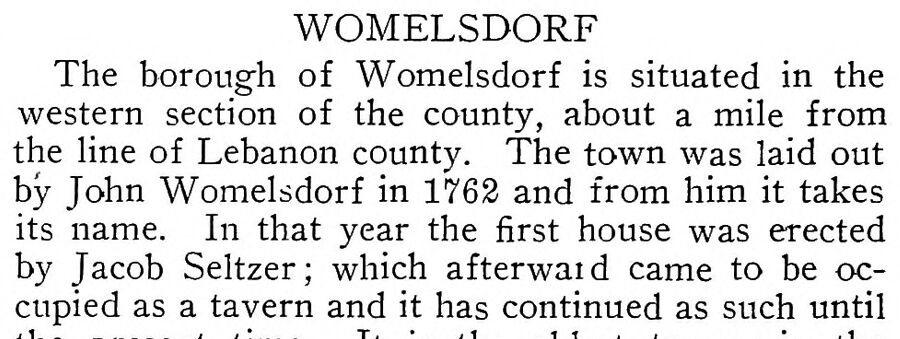
WOMELSDORF The borough of Womelsdorf is situated in the western section of the county, about a mile from the line of Lebanon county. The town was laid out by John Womelsdorf in 1763 and from him it takes its name. In that year the first house was erected by Jacob Seltzer; which afterwaid came to be occupied as a tavern and it has continued as such until
Text read by machine from the scan; it may contain errors.
History of Berks county in Pennsylvania1886 · page 873Read the page →
Read the text
The borough of Womelsdorf is situated on the " Berks and Dauphin Turnpike," fourteen miles from Reading and about a mile north of Womelsdorf Station, on the Lebanon Valley Railroad. It contains three churches, a fine public school build-
Text read by machine from the scan; it may contain errors.
Historical and biographical annals of Berks County, Pennsylvania, embracing a concise history of the county and a genealogical and biographical record of representative families, comp. by Morton L. Montgomery ..1909 · page 423Read the page →
Read the text
town, and also the schools in Heidelberg township. His boyhood days were passed upon a farm in Ohio, but when the Civil war broke out he returned to his home, and enlisted from Womelsdorf in June, 1863, becoming a member of Company K, 42d Pennsylvania militia, which was enlisted for three months, but was in service only six weeks, going as far as Hagerstown, Md., and then returning to Womelsdorf. On Feb. 12, 1864, he enlisted
Text read by machine from the scan; it may contain errors.
Scans and text from the Internet Archive. Books published in 1930 or earlier, which are in the public domain.
Timeline
Womelsdorf, 1762 to 1962
Woven from the archive, old maps, post office records, the National Register and the people born here.
Nothing in the archives for these yearsWeddings on Main Street, storms, parades, school pictures, the old store. If it’s in your family album, it belongs here.
Nothing in the archives for these yearsWeddings on Main Street, storms, parades, school pictures, the old store. If it’s in your family album, it belongs here.
In 1762, according to Wikidata. Womelsdorf’s post office opened in 1807, and the census of 1840 counted 849 people here.
How does Womelsdorf rank for history?
Womelsdorf is more historic than 97% of U.S. towns, #87 of 1,035 in Pennsylvania. The History grade combines the town’s founding era, the share of homes built before 1940 and its National Register listings. It’s a character grade, so it isn’t part of the overall grade. How it works.
What is on the National Register in Womelsdorf?
One place: the Womelsdorf Historic District (listed 1982).
How old are the homes in Womelsdorf?
20% of Womelsdorf’s homes were built before 1940 (Census estimate, ±8.8 points), against a typical 18% for a Pennsylvania town; the median home was built in 1976.
Founding dates: Wikidata, Wikipedia, the U.S. post office records of Blevins & Helbock (CC0) and the Census. Homes by year built: Census ACS 2020–24. National Register of Historic Places: National Park Service (list of May 22, 2026). Old photos, postcards and papers: Wikimedia Commons, the Library of Congress and other public archives, credited on each item’s page. Maps: U.S. Geological Survey historical topographic maps (via Esri) and Sanborn fire-insurance maps (Library of Congress). History text and census tables: Wikipedia (CC BY-SA 4.0). Places that used to be: USGS Geographic Names Information System (2021).
From Wikimedia Commons (6), the National Register of Historic Places (1), Wikipedia, Wikidata and Wikipedia for famous people, U.S. Geological Survey historical maps, U.S. Census counts (via Wikipedia), the US Post Offices dataset (Blevins & Helbock), the USGS Geographic Names Information System, Sanborn fire insurance maps (Library of Congress) and old county and town histories (Internet Archive). Archive images are copied here with their credits and licenses, shown on each photo’s page. Refreshed monthly.




 1962
 2018
 2011
