The story
Read it all →How Wheatfield Township came to be
From Wikipedia’s history of Wheatfield Township.
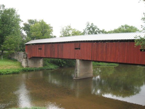
The Dellville Covered Bridge was added to the National Register of Historic Places in 1980.
Text from Wikipedia, licensed CC BY-SA 4.0.
Each edition grades its towns against each other only.
More historic than 54% of U.S. towns · #688 of 1,035 in Pennsylvania. What drives it
Its Register listing is the Dellville Covered Bridge. Below: maps from 1907 on and old-book passages.
More historic than 54% of U.S. towns, on its age, its old homes and the National Register.
On its age, its old homes and the National Register, Wheatfield Township is more historic than 54% of U.S. towns, #688 of 1,035 in Pennsylvania. Its National Register listings hold the grade up; its share of homes from before 1940 pulls it down.
Pennsylvania towns list about as much on the Register as the country (a typical Pennsylvania town has 2.1 per 10,000 residents, the U.S. 2.4), so Wheatfield Township’s 3.1 sits near the middle of its state (61% of Pennsylvania towns have fewer) while its 1 listings outnumber those of 51% of U.S. towns.
Founding year: our sources. Homes: Census ACS 2020–24. National Register: National Park Service, May 2026 list; each listing counted once (boundary changes and added documentation belong to their listing), and a historic district counts its contributing buildings. How TownRatings grades history →
Read from the archive, the National Register and the record. The page puts what stands out first.
Four other post offices opened and closed inside today’s town.
US Post Offices dataset (Blevins & Helbock, CC0). Places and cemeteries from the USGS Geographic Names Information System (2021).
The first neighbors to add old photos shape how Wheatfield Township’s history is told.
Every edition of the U.S. Geological Survey’s map of Wheatfield Township. Tap a year, or press play to watch the town change.

U.S. Geological Survey historical topographic maps (public domain), via Esri’s collection of the scans. The red ring marks the center of Wheatfield Township.
From Wikipedia’s history of Wheatfield Township.
The Dellville Covered Bridge was added to the National Register of Historic Places in 1980.
Text from Wikipedia, licensed CC BY-SA 4.0.
Passages that mention Wheatfield Township, cut from the printed page as they were published.

In 1836 Wheatfield Township paid its teachers $14.25 a month. In 1838 there were eighty schools in the county, with terms ranging from three to seven months. ‘The salaries were from $15.00 to $23.00 per month. In 1840 Buffalo Township dispensed with schools altogether in order to use the funds to build schoolhouses.
Text read by machine from the scan; it may contain errors.
Pennell’s Church. During 1845 Andrew Pennell donated a plot at the corner of his farm, in Wheatfield Township, for the purpose of erecting a Methodist church. The present stone church was erected on this site, the building committee being Robert Jones, George Bruner and Andrew Pennell. Since then this pulpit has been supplied by the Duncannon Methodist pastors at intervals. The church is the property of the Duncannon congregation.
Text read by machine from the scan; it may contain errors.Scans and text from the Internet Archive. Books published in 1930 or earlier, which are in the public domain.
Woven from the archive, old maps, post office records, the National Register and the people born here.
 On the mapFirst mapped by the U.S. Geological Survey
Weddings on Main Street, storms, parades, school pictures, the old store. If it’s in your family album, it belongs here.
The country’s official list of buildings and places worth saving.
National Park Service, National Register of Historic Places. Photos from Wikimedia Commons, credited on each place’s page.
Nobody well known was born in Wheatfield Township itself, so here are the best known from just nearby.
Each neighbor’s History grade, on the same three inputs.
Wheatfield Township is more historic than 54% of U.S. towns, #688 of 1,035 in Pennsylvania. The History grade combines the town’s founding era, the share of homes built before 1940 and its National Register listings. It’s a character grade, so it isn’t part of the overall grade. How it works.
One place: the Dellville Covered Bridge (listed 1980).
10% of Wheatfield Township’s homes were built before 1940 (Census estimate, ±6.2 points), against a typical 18% for a Pennsylvania town; the median home was built in 1982.
What the archives can’t tell you, neighbors can.
Founding dates: Wikidata, Wikipedia, the U.S. post office records of Blevins & Helbock (CC0) and the Census. Homes by year built: Census ACS 2020–24. National Register of Historic Places: National Park Service (list of May 22, 2026). Old photos, postcards and papers: Wikimedia Commons, the Library of Congress and other public archives, credited on each item’s page. Maps: U.S. Geological Survey historical topographic maps (via Esri) and Sanborn fire-insurance maps (Library of Congress). History text and census tables: Wikipedia (CC BY-SA 4.0). Places that used to be: USGS Geographic Names Information System (2021).
From the National Register of Historic Places (1), Wikipedia, U.S. Geological Survey historical maps, the US Post Offices dataset (Blevins & Helbock), the USGS Geographic Names Information System and old county and town histories (Internet Archive). Archive images are copied here with their credits and licenses, shown on each photo’s page. Refreshed monthly.