Uniontown dates to 1776, and 49% of its homes were built before 1940
More historic than 98% of U.S. towns · #79 of 1,035 in Pennsylvania. What drives it
5 places in town are on the National Register, among them a historic district with 113 buildings. Below: 17 old photos and papers, maps from 1886 on, and the census since 1800.
Founding year: Wikidata. First post office: 1795.The full story ↓
History grade
What drives Uniontown’s History grade
On its age, its old homes and the National Register, Uniontown is more historic than 98% of U.S. towns, #79 of 1,035 in Pennsylvania. All 3 inputs are above most U.S. towns; its share of homes from before 1940 ranks highest and its age lowest.
A+
HistoryA character grade: shown, never part of Uniontown’s overall grade.
Pennsylvania towns list about as much on the Register as the country (a typical Pennsylvania town has 2.1 per 10,000 residents, the U.S. 2.4), so Uniontown’s 122 sits above most of its state (90% of Pennsylvania towns have fewer) while its 119 historic buildings outnumber those of 90% of U.S. towns.
How sure. Graded on any two of the three inputs instead, the letter would range from A to A+. The pre-1940 share is a Census survey estimate (±6.5 points). Two sources give 1776.
Founding year: Wikidata (other dates in Quick answers). Homes: Census ACS 2020–24. National Register: National Park Service, May 2026 list; each listing counted once (boundary changes and added documentation belong to their listing), and a historic district counts its contributing buildings. How TownRatings grades history →
What stands out about Uniontown’s past
Read from the archive, the National Register and the record. The page puts what stands out first.
National Park Service, National Register of Historic Places. Photos from Wikimedia Commons, credited on each place’s page.
Every building
Uniontown, building by building, 1886–1914
Fire insurance maps drew every building, what it was made of and what it was used for, so insurers could price the risk of fire. Pick a year, then a sheet.
10 miles (16 km) southeast of Uniontown is Fort Necessity, built by George Washington during the French and Indian War (part of the international Seven Years' War) as well as the site of the Battle of Jumonville Glen, where the North American branch of the war began.
Uniontown lies within the foothills of the Allegheny Mountains at an elevation of 999 feet (304 meters) above sea level. The city rests at the base of Chestnut Ridge, the westernmost ridge of the Appalachian Mountains.
meeting house for public worship be built, and in July following it was resolved that two meeting houses be built. It would appear that the first meeting house was built on the Rogers farm some six miles south of Uniontown, near Ashcraft's fort. And at a meeting held September 15, 1787, it was resolved that a meeting house be built on the great road about one-fourth of a mile from Uniontown. This was the second meeting house 708
Text read by machine from the scan; it may contain errors.
Nelson's biographical dictionary and historical reference book of Fayette County, Pennsylvania1900 · page 277Read the page →
Read the text
branch into the county was the Pennsylvania, which obtained the Southwest Pennsylvania road, which was completed from Greensburg to Uniontown in 1876, and later extended to Frairchance by buying the Uniontown and West \'irginia railroad. It also secured the partly finished Redstone branch of the Pittsburg, Virginia and Charleston
Text read by machine from the scan; it may contain errors.
Nelson's biographical dictionary and historical reference book of Fayette County, Pennsylvania1900Read the page →
Read the text
branch into the county was the Pennsylvania, \\iiich obtained the Southwest Pennsylvania road, which was completed from Greensburg to Uniontown in 1876, and later extended to Frairchance by buying the Uniontown and West A'irginia railroad. It also secured the partly finished Redstone branch of the Pittsburg, Virginia and Charleston
Text read by machine from the scan; it may contain errors.
History of Fayette County, Pennsylvania1882 · page 322Read the page →
Read the text
John Cooper and Samuel Breeze were appointed to this circuit. They came to Uniontown, probably in June, as Bishop Asbury preached in Uniontown July 7, 1784, to a congregation of seven hundred persons, and it is probable that Cooper and Breeze came with him. But the peculiar polity of Methodism in working the laymen as local preachers and exhorters had forestalled the appearance of the regular circuit preach-
Text read by machine from the scan; it may contain errors.
Scans and text from the Internet Archive. Books published in 1930 or earlier, which are in the public domain.
Timeline
Uniontown, 1776 to 1964
Woven from the archive, old maps, post office records, the National Register and the people born here.
Nothing in the archives for these yearsWeddings on Main Street, storms, parades, school pictures, the old store. If it’s in your family album, it belongs here.
In 1776, according to Wikidata. Uniontown’s post office opened in 1795, and the census of 1800 counted 624 people here.
How does Uniontown rank for history?
Uniontown is more historic than 98% of U.S. towns, #79 of 1,035 in Pennsylvania. The History grade combines the town’s founding era, the share of homes built before 1940 and its National Register listings. It’s a character grade, so it isn’t part of the overall grade. How it works.
What is on the National Register in Uniontown?
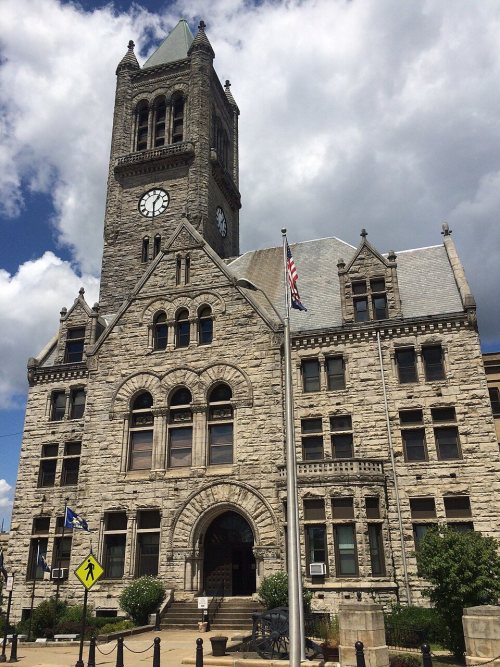
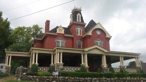
5 listings: 4 buildings, among them the John P. Conn House (listed 1988, the first), and 1 historic district, the Uniontown Downtown Historic District, with 113 contributing buildings. 119 historic buildings in all.
How old are the homes in Uniontown?
49% of Uniontown’s homes were built before 1940 (Census estimate, ±6.5 points), against a typical 18% for a Pennsylvania town; the median home was built in 1942.
Founding dates: Wikidata, Wikipedia, the U.S. post office records of Blevins & Helbock (CC0) and the Census. Homes by year built: Census ACS 2020–24. National Register of Historic Places: National Park Service (list of May 22, 2026). Old photos, postcards and papers: Wikimedia Commons, the Library of Congress and other public archives, credited on each item’s page. Maps: U.S. Geological Survey historical topographic maps (via Esri) and Sanborn fire-insurance maps (Library of Congress). History text and census tables: Wikipedia (CC BY-SA 4.0). Places that used to be: USGS Geographic Names Information System (2021).
From Wikimedia Commons (17), Wikidata (1), the National Register of Historic Places (5), Wikipedia, Wikidata and Wikipedia for famous people, U.S. Geological Survey historical maps, U.S. Census counts (via Wikipedia), the US Post Offices dataset (Blevins & Helbock), the USGS Geographic Names Information System, Sanborn fire insurance maps (Library of Congress) and old county and town histories (Internet Archive). Archive images are copied here with their credits and licenses, shown on each photo’s page. Refreshed monthly.




 c. 1911
 1912
 1916
 1917
 1917
 1923
 c. 1930
 c. 1930
 c. 1930
 c. 1930
 c. 1930
 c. 1930


