Guest, Sign inJoin

Post to South Renovo

We’ll email a one-tap link to publish your post. No password, and nothing is public until you click it.
Already a member? Sign in
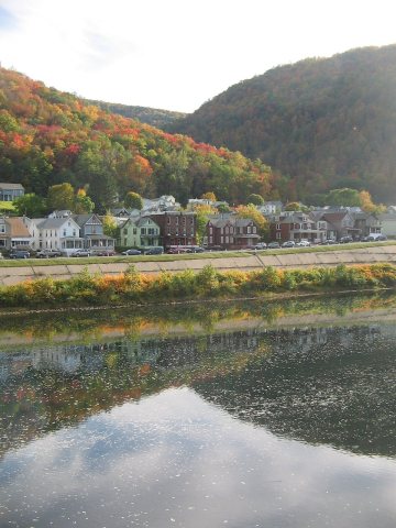
South Renovo houses on the West Branch Susquehanna RiverPhoto: Beyond My Ken · CC BY-SA 4.0
–Not graded
History · South Renovo

South Renovo dates to 1881, and 76% of its homes were built before 1940

Below: maps from 1946 on and the census since 1890.

1881founded
0on the National Register
76%homes built before 1940
Photo: Beyond My Ken · CC BY-SA 4.0
Quick answers

How South Renovo began

When was South Renovo founded?

1881

South Renovo dates its founding to 1881 (Wikidata). The census first counted it in 1890.

First census: 135 in 18902020 census: 411145 years
Founding year: Wikidata.

What stands out about South Renovo’s past

Read from the archive, the National Register and the record. The page puts what stands out first.

★ What stands out · Help out

Start South Renovo’s collection

The first neighbors to add old photos shape how South Renovo’s history is told.

Decades since 1900 with photos
00s10s20s30s40s50s60s70s80s90s
0 of 10 decades. The empty ones are waiting for someone’s album.
The story so far

South Renovo, in brief

Wikipedia doesn’t have a history of South Renovo yet. The photos, dates and memories neighbors add here are how it gets written.

South Renovo is a borough in Clinton County, Pennsylvania, United States, located on the West Branch Susquehanna River, directly across from Renovo. As of the 2020 census, South Renovo had a population of 411. Historically, the economy of the area was based on lumbering, but when the mountains of the region had been stripped of their first-growth forest, the industry collapsed. There are also deposits of bituminous coal and fire clay in the region. Today, the area largely consists of state land in the form of state forests, state parks and game lands. The region is known as the Pennsylvania Wilds.

South Renovo was established in 1881. Between the 2010 and 2020 censuses its population fell from 439 to 411 (-6%).

Intro from Wikipedia. Population: U.S. Census Bureau.

People over time

South Renovo, census by census

02004006008001,0001,2001,400190019201940196019802000Peak: 1,291

Peaked at 1,291 in 1920; 439 people lived here in 2010.

13 censuses, 1890–2010.

U.S. Census Bureau decennial counts, from the census table on South Renovo’s Wikipedia page.

Timeline

South Renovo, 1881 to 1946

Woven from the archive, old maps, post office records, the National Register and the people born here.

  1. 19th century
  2. 1881
    FoundingSouth Renovo is established
  3. 20th century
  4. 1920CensusPopulation peaks at 1,291
  5. 1946On the mapFirst mapped by the U.S. Geological Survey
By decade

South Renovo, decade by decade

On the map

South Renovo on the map, 1946 to 1986

Every edition of the U.S. Geological Survey’s map of South Renovo. Tap a year, or press play to watch the town change.

South Renovo on the 1946 USGS mapSouth Renovo on the 1971 USGS mapSouth Renovo on the 1986 USGS map1946Renovo East sheet · 1:24,000

U.S. Geological Survey historical topographic maps (public domain), via Esri’s collection of the scans. The red ring marks the center of South Renovo.

Famous people

Famous people close to South Renovo

Nobody well known was born in South Renovo itself, so here are the best known from just nearby.

See all →
Stories next door

History across the town line

Each neighbor’s History grade, on the same three inputs.

Questions about South Renovo’s history

What year was South Renovo founded?

In 1881, according to Wikidata. the census of 1890 counted 135 people here.

Memory lane

What the archives can’t tell you, neighbors can.

Town Square →
Start a conversation
Sources

Where this page comes from

Founding dates: Wikidata, Wikipedia, the U.S. post office records of Blevins & Helbock (CC0) and the Census. Homes by year built: Census ACS 2020–24. National Register of Historic Places: National Park Service (list of May 22, 2026). Old photos, postcards and papers: Wikimedia Commons, the Library of Congress and other public archives, credited on each item’s page. Maps: U.S. Geological Survey historical topographic maps (via Esri) and Sanborn fire-insurance maps (Library of Congress). History text and census tables: Wikipedia (CC BY-SA 4.0). Places that used to be: USGS Geographic Names Information System (2021). How TownRatings grades history →

From Wikimedia Commons (6), U.S. Geological Survey historical maps, U.S. Census counts (via Wikipedia) and the USGS Geographic Names Information System. Archive images are copied here with their credits and licenses, shown on each photo’s page. Refreshed monthly.