Somerset dates to 1795, and 24% of its homes were built before 1940
More historic than 93% of U.S. towns · #135 of 1,035 in Pennsylvania. What drives it
2 places in town are on the National Register, among them a historic district with 190 buildings. Below: 6 old photos and papers, maps from 1887 on, and the census since 1800.
Founding year: Wikidata. First post office: 1797.The full story ↓
History grade
What drives Somerset’s History grade
On its age, its old homes and the National Register, Somerset is more historic than 93% of U.S. towns, #135 of 1,035 in Pennsylvania. All 3 inputs are above most U.S. towns; its National Register listings ranks highest and its age lowest.
A
HistoryA character grade: shown, never part of Somerset’s overall grade.
Pennsylvania towns list about as much on the Register as the country (a typical Pennsylvania town has 2.1 per 10,000 residents, the U.S. 2.4), so Somerset’s 321 sits above most of its state (93% of Pennsylvania towns have fewer) while its 191 historic buildings outnumber those of 93% of U.S. towns.
NoteThe founding year comes from Wikidata alone; no second source gives 1795.
How sure. Graded on any two of the three inputs instead, the letter would range from A− to A. The pre-1940 share is a Census survey estimate (±6.6 points).
Founding year: Wikidata (other dates in Quick answers). Homes: Census ACS 2020–24. National Register: National Park Service, May 2026 list; each listing counted once (boundary changes and added documentation belong to their listing), and a historic district counts its contributing buildings. How TownRatings grades history →
What stands out about Somerset’s past
Read from the archive, the National Register and the record. The page puts what stands out first.
National Park Service, National Register of Historic Places. Photos from Wikimedia Commons, credited on each place’s page.
Every building
Somerset, building by building, 1887–1924
Fire insurance maps drew every building, what it was made of and what it was used for, so insurers could price the risk of fire. Pick a year, then a sheet.
Somerset was a central stage for the Whiskey Rebellion of 1794. Several rebellion leaders, including Harmon Husband, lived in Somerset. The federal militia sent to put down the rebellion worked from its headquarters in the nearby town of Berlin.
A major fire on the afternoon of May 9, 1872, destroyed a significant portion of the town within just a few hours.
In July 2002, nine miners were trapped for 77 hours, 240 feet (73 m) underground, by flooding in the Quecreek coal mine, just outside Somerset. All nine miners were rescued. The Quecreek Mine Rescue was chronicled by journalists from around the world and was televised globally.
Passages that mention Somerset, cut from the printed page as they were published.
History of Bedford, Somerset, and Fulton Counties, Pennsylvania1884 · page 178Read the page →
Read the text
Meanwhile the Somerset & Mineral Point railroad, connecting the county seat of Somerset county with the Pittsburgh & Connellsville railroad at Rockwood, was built by the people of the town of Somerset and others along the line.- It proved to be a convenient and favorite route of travel with the general public, but like many other enterprises of this kind throughout
Text read by machine from the scan; it may contain errors.
History of Bedford, Somerset, and Fulton Counties, Pennsylvania1884 · page 391Read the page →
Read the text
On March 26, 1804, an act was passed erecting the county of Cambria from parts of Hun-_ tingdon, Somerset and Bedford. As a result, Cambria township of Somerset county was set off into the new county, and Somerset was reduced to its present proportions.
Text read by machine from the scan; it may contain errors.
History of Bedford and Somerset Counties, Pennsylvania, with genealogical and personal history1906 · page 262Read the page →
Read the text
(II) John Cobaugh, eldest son of Frederick Cobaugh, was a native of Johnstown, Pennsylvania, born in March, 1788, died January, 1874 He went to Somerset county about 1805, and there settled on a farm in Somerset township, two and a half miles north of the town of Somerset, which is now owned by George W. G. Cobaugh. John Cobaugh married Rebecca Good, who lived to be eighty years of age, and by whom he had two children, viz.: George and Sarah (Mrs. Lichty).
Text read by machine from the scan; it may contain errors.
History of Bedford and Somerset Counties, Pennsylvania, with genealogical and personal history1906 · page 61Read the page →
Read the text
AVilliam M. Schrock, a prominent and widely known citizen of Somerset, Somerset county, Pennsylvania, former proprietor and editor of the Somerset Standard, who rendered signal service to the government during the Civil war, and who is at present engineer and superintendent of the work of constructing the bridges in Somerset county, traces his descent to ancestors who had for their home the beautiful country of Switzerland.
Text read by machine from the scan; it may contain errors.
Scans and text from the Internet Archive. Books published in 1930 or earlier, which are in the public domain.
By decade
Somerset, decade by decade
3 decades in the archive, from the 1900s to the 1990s. Scroll each row; tap a photo for its story.
Nothing in the archives for these yearsWeddings on Main Street, storms, parades, school pictures, the old store. If it’s in your family album, it belongs here.
In 1795, according to Wikidata. Somerset’s post office opened in 1797, and the census of 1800 counted 280 people here.
How does Somerset rank for history?
Somerset is more historic than 93% of U.S. towns, #135 of 1,035 in Pennsylvania. The History grade combines the town’s founding era, the share of homes built before 1940 and its National Register listings. It’s a character grade, so it isn’t part of the overall grade. How it works.
What is on the National Register in Somerset?
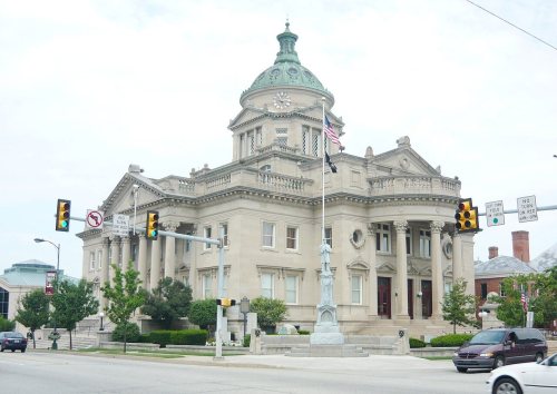
Two places: the Somerset County Courthouse (listed 1980) and the Uptown Somerset Historic District (1995).
How old are the homes in Somerset?
24% of Somerset’s homes were built before 1940 (Census estimate, ±6.6 points), against a typical 18% for a Pennsylvania town; the median home was built in 1964.
Founding dates: Wikidata, Wikipedia, the U.S. post office records of Blevins & Helbock (CC0) and the Census. Homes by year built: Census ACS 2020–24. National Register of Historic Places: National Park Service (list of May 22, 2026). Old photos, postcards and papers: Wikimedia Commons, the Library of Congress and other public archives, credited on each item’s page. Maps: U.S. Geological Survey historical topographic maps (via Esri) and Sanborn fire-insurance maps (Library of Congress). History text and census tables: Wikipedia (CC BY-SA 4.0). Places that used to be: USGS Geographic Names Information System (2021).
From Wikimedia Commons (12), the National Register of Historic Places (2), Wikipedia, U.S. Geological Survey historical maps, U.S. Census counts (via Wikipedia), the US Post Offices dataset (Blevins & Helbock), the USGS Geographic Names Information System, Sanborn fire insurance maps (Library of Congress) and old county and town histories (Internet Archive). Archive images are copied here with their credits and licenses, shown on each photo’s page. Refreshed monthly.




 c. 1930
 c. 1930
 c. 1930
 2006
 2006
 2006
 2006
 2003
 2003


