Founding year: Wikidata. First post office: 1826.The full story ↓
History grade
What drives Sayre’s History grade
On its age, its old homes and the National Register, Sayre is more historic than 56% of U.S. towns, #658 of 1,035 in Pennsylvania. Its share of homes from before 1940 holds the grade up; its National Register listings pull it down.
B
HistoryA character grade: shown, never part of Sayre’s overall grade.
Pennsylvania towns list about as much on the Register as the country (a typical Pennsylvania town has 2.1 per 10,000 residents, the U.S. 2.4), so Sayre’s 0.0 sits below most of its state (25% of Pennsylvania towns have fewer) while its 0 listings outnumber those of 23% of U.S. towns.
How sure. Graded on any two of the three inputs instead, the letter would range from C− to B+. The pre-1940 share is a Census survey estimate (±7.8 points). Two sources give 1871.
Founding year: Wikidata (other dates in Quick answers). Homes: Census ACS 2020–24. National Register: National Park Service, May 2026 list; each listing counted once (boundary changes and added documentation belong to their listing), and a historic district counts its contributing buildings. How TownRatings grades history →
What stands out about Sayre’s past
Read from the archive, the National Register and the record. The page puts what stands out first.
Fire insurance maps drew every building, what it was made of and what it was used for, so insurers could price the risk of fire. Pick a year, then a sheet.
Nothing in the archives for these yearsWeddings on Main Street, storms, parades, school pictures, the old store. If it’s in your family album, it belongs here.
In 1783, Prince Bryant's gristmill was founded within the Milltown section of what is now present-day Sayre. Prince Bryant's later became Shepards Mill in 1788 - the only mill between Binghamton, NY and Wilkes-Barre, PA. It served as a shipping point for oil, lumber and plaster by raft to settlements on the Susquehanna. Later, there were nine mills operating at Milltown.
The area of present-day N. Keystone Avenue near the Sayre Borough / South Waverly Borough line was known by pioneers as the "Pine Plains." In 1790 Timothy Pickering met Red Jacket and his Senecas here. They were on the way to the peace council at Tioga Point - present day Athens, PA.
Passages that mention Sayre, cut from the printed page as they were published.
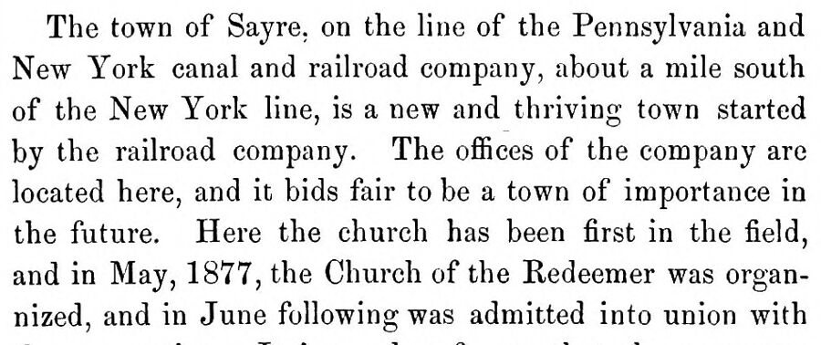
History of Bradford County, Pennsylvania1878 · page 167Read the page →
Read the text
The town of Sayre. on the line of the Pennsylvania and New York canal and railroad company, about a mile south of the New York line, is a new and thriving town started by the railroad company. The offices of the company are located here, and it bids fair to be a town of importance in the future. Here the church has been first in the field, and in May, 1877, the Church of the Redeemer was organnized, and in June following was admitted into union with
Text read by machine from the scan; it may contain errors.
History of Bradford County, Pennsylvania1878 · page 258Read the page →
Read the text
Two other railroads, which have passed under the same management, were opened in 1871 or '72, viz., the Geneva, Ithaca and Sayre railroad and the Southern Central of New York, which connect with the Pennsylvania and New York at Sayre, making this place an important railroad centre.
Text read by machine from the scan; it may contain errors.
History of Bradford County, Pennsylvania, with biographical selections1891 · page 1261Read the page →
Read the text
vey of the location of the, then, Athens & Ithaca Railroad, now the Ithaca Branch of the Lehigh Valley Railroad, being on the same from its inception to its final completion. Soon after this he laid out and staked the, now, borough of Sayre, besides many other works in the engineering line. He entered the service as engineer and draughtsman for the Lehigh Valley Railroad, Northern Division, January 21, 1882, and is in that position now. He has made many maps of land surveys as well as of railroads, both right of way and mechanical. In
Text read by machine from the scan; it may contain errors.
History and Geography of Bradford County Pennsylvania1926Read the page →
Read the text
Sayre Borough.Sayre is distinctively a railroad town and the only one in the county. It had its origin from the building of a branch of the Pennsylvania & New York railroad, where a junction of railroads was established. The projectors of the town were Howard Elmer, Charles L.
Text read by machine from the scan; it may contain errors.
Scans and text from the Internet Archive. Books published in 1930 or earlier, which are in the public domain.
Timeline
Sayre, 1826 to 1968
Woven from the archive, old maps, post office records, the National Register and the people born here.
In 1871, according to Wikidata. Sayre’s post office opened in 1826, and the census of 1880 counted 729 people here.
How does Sayre rank for history?
Sayre is more historic than 56% of U.S. towns, #658 of 1,035 in Pennsylvania. The History grade combines the town’s founding era, the share of homes built before 1940 and its National Register listings. It’s a character grade, so it isn’t part of the overall grade. How it works.
How old are the homes in Sayre?
55% of Sayre’s homes were built before 1940 (Census estimate, ±7.8 points), against a typical 18% for a Pennsylvania town; the median home was built in 1938.
Founding dates: Wikidata, Wikipedia, the U.S. post office records of Blevins & Helbock (CC0) and the Census. Homes by year built: Census ACS 2020–24. National Register of Historic Places: National Park Service (list of May 22, 2026). Old photos, postcards and papers: Wikimedia Commons, the Library of Congress and other public archives, credited on each item’s page. Maps: U.S. Geological Survey historical topographic maps (via Esri) and Sanborn fire-insurance maps (Library of Congress). History text and census tables: Wikipedia (CC BY-SA 4.0). Places that used to be: USGS Geographic Names Information System (2021).
From Wikimedia Commons (16), the Library of Congress (2), Wikipedia, Wikidata and Wikipedia for famous people, U.S. Geological Survey historical maps, U.S. Census counts (via Wikipedia), the US Post Offices dataset (Blevins & Helbock), the USGS Geographic Names Information System, Sanborn fire insurance maps (Library of Congress) and old county and town histories (Internet Archive). Archive images are copied here with their credits and licenses, shown on each photo’s page. Refreshed monthly.


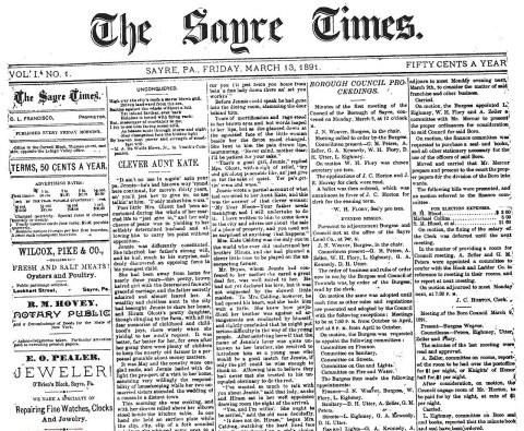 1891
 1900
 1907
 1909
 1923
 c. 1930
 c. 1930
 c. 1930
 c. 1930
 c. 1930
 c. 1930
 c. 1930
 c. 1930
 c. 1930
 c. 1930
 c. 1930
 c. 1930
 1968