Founding year: the first Reynoldsville post office (Blevins & Helbock, CC0).The full story ↓
History grade
What drives Reynoldsville’s History grade
On its age, its old homes and the National Register, Reynoldsville is more historic than 74% of U.S. towns. Its share of homes from before 1940 holds the grade up; its age pulls it down.
B+
HistoryA character grade: shown, never part of Reynoldsville’s overall grade.
Pennsylvania towns list about as much on the Register as the country (a typical Pennsylvania town has 2.1 per 10,000 residents, the U.S. 2.4), so Reynoldsville’s 4.1 sits near the middle of its state (64% of Pennsylvania towns have fewer) while its 1 listings outnumber those of 51% of U.S. towns.
How sure. Graded on any two of the three inputs instead, the letter would range from C+ to A. The pre-1940 share is a Census survey estimate (±8.3 points). The founding year is the first post office, not a stated founding date.
Founding year: the first post office (other dates in Quick answers). Homes: Census ACS 2020–24. National Register: National Park Service, May 2026 list; each listing counted once (boundary changes and added documentation belong to their listing), and a historic district counts its contributing buildings. How TownRatings grades history →
What stands out about Reynoldsville’s past
Read from the archive, the National Register and the record. The page puts what stands out first.
Peaked at 4,116 in 1920; 2,549 people lived here in 2020.
15 censuses, 1880–2020.
U.S. Census Bureau decennial counts, from the census table on Reynoldsville’s Wikipedia page.
Every building
Reynoldsville, building by building, 1894–1912
Fire insurance maps drew every building, what it was made of and what it was used for, so insurers could price the risk of fire. Pick a year, then a sheet.
In 1855, a man by the name of Tilton Reynolds owned the land in what is today Reynoldsville. He began selling lots of property in the hopes of starting a town. Over the course of the 19th century, Reynoldsville would grow into the town that is it is today. Reynoldsville would grow its industries in the way of silk mills, brick and tile works, a tannery, a macaroni factory, and an asbestos plant to provide employment. The borough was greatly enlarged in 1913 when it annexed West Reynoldsville (population 993 in 1910) and three large adjacent areas.
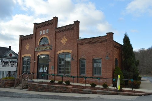
The Herpel Brothers Foundry and Machine Shop was added to the National Register of Historic Places in 2004.
Passages that mention Reynoldsville, cut from the printed page as they were published.
History of Jefferson county, Pennsylvania, with illustrations and biographical sketches of some of its prominent men and pioneers1888 · page 616Read the page →
Read the text
changed from Prospect Hill to Reynoldsville, which was done, and he was appointed postmaster. When Thomas Reynolds gave the name to the town by having the post-office called Reynoldsville, there were no houses west of the school-house hill, between Thomas Reynolds and Woodward Reynolds's homes, except a small house built by Woodward Reynolds, on the site of the present Belnap house, and a log house that stood somewhere near the present Presbyterian Church, until Archibald Campbell put up a row of small buildings east of what is now Sixth street. Archie Campbell, as he was called, was
Text read by machine from the scan; it may contain errors.
History of Jefferson county, Pennsylvania, with illustrations and biographical sketches of some of its prominent men and pioneers1888 · page 695Read the page →
Read the text
proving a success from the first, and continues in the lead to-day. His last but crowning eftbrt in Du Bois was his untiring efforts which resulted in the establishment of the First National Bank of Du Bois city. Early in the spring of 1883, in company with Mr. F. K. Arnold, of Reynoldsville. aided by other citizens of Du Bois and Reynoldsville, the plan was matured, and sufficient stock, amounting to $50,000 secured, to warrant the purchase of a lot, and the erection of a brick bank building, commodious and modern in all its appointments. This building is located on Long street, the identical street which his own name suggested in 1875. On the ist of August, 1883, the new
Text read by machine from the scan; it may contain errors.
Scans and text from the Internet Archive. Books published in 1930 or earlier, which are in the public domain.
Timeline
Reynoldsville, 1850 to 1922
Woven from the archive, old maps, post office records, the National Register and the people born here.
Nothing in the archives for these yearsWeddings on Main Street, storms, parades, school pictures, the old store. If it’s in your family album, it belongs here.
Every edition of the U.S. Geological Survey’s map of Reynoldsville. Tap a year, or press play to watch the town change.
1922Du Bois sheet · 1:62,500
U.S. Geological Survey historical topographic maps (public domain), via Esri’s collection of the scans. The red ring marks the center of Reynoldsville.
Then & now
Stand where they stood
No then-and-now pairs yet. Take a photo from the same spot as an old one and they appear here side by side.
Retake this viewReynoldsville, Pennsylvania, 1909
Find the spot, match the angle, and add your photo. It becomes the first then-and-now pair on Reynoldsville’s page.
The Reynoldsville post office opened in 1850, the earliest record of the town by name (U.S. post office records).
How does Reynoldsville rank for history?
Reynoldsville is more historic than 74% of U.S. towns. The History grade combines the town’s founding era, the share of homes built before 1940 and its National Register listings. It’s a character grade, so it isn’t part of the overall grade. How it works.
What is on the National Register in Reynoldsville?
One place: the Herpel Brothers Foundry and Machine Shop (listed 2004).
How old are the homes in Reynoldsville?
50% of Reynoldsville’s homes were built before 1940 (Census estimate, ±8.3 points), against a typical 18% for a Pennsylvania town; the median home was built in 1940.
Founding dates: Wikidata, Wikipedia, the U.S. post office records of Blevins & Helbock (CC0) and the Census. Homes by year built: Census ACS 2020–24. National Register of Historic Places: National Park Service (list of May 22, 2026). Old photos, postcards and papers: Wikimedia Commons, the Library of Congress and other public archives, credited on each item’s page. Maps: U.S. Geological Survey historical topographic maps (via Esri) and Sanborn fire-insurance maps (Library of Congress). History text and census tables: Wikipedia (CC BY-SA 4.0). Places that used to be: USGS Geographic Names Information System (2021).
From Wikimedia Commons (5), the Library of Congress (1), the National Register of Historic Places (1), Wikipedia, Wikidata and Wikipedia for famous people, U.S. Geological Survey historical maps, U.S. Census counts (via Wikipedia), the US Post Offices dataset (Blevins & Helbock), the USGS Geographic Names Information System, Sanborn fire insurance maps (Library of Congress) and old county and town histories (Internet Archive). Archive images are copied here with their credits and licenses, shown on each photo’s page. Refreshed monthly.


 1909
 1909
 2009
 2009
 2009