Founding year: Wikidata. First post office: 1826.The full story ↓
History grade
What drives Punxsutawney’s History grade
On its age, its old homes and the National Register, Punxsutawney is more historic than 93% of U.S. towns, #145 of 1,035 in Pennsylvania. All 3 inputs are above most U.S. towns; its share of homes from before 1940 ranks highest and its National Register listings lowest.
A
HistoryA character grade: shown, never part of Punxsutawney’s overall grade.
Pennsylvania towns list about as much on the Register as the country (a typical Pennsylvania town has 2.1 per 10,000 residents, the U.S. 2.4), so Punxsutawney’s 7.1 sits above most of its state (72% of Pennsylvania towns have fewer) while its 4 listings outnumber those of 68% of U.S. towns.
How sure. Graded on any two of the three inputs instead, the letter would range from A− to A. The pre-1940 share is a Census survey estimate (±7.3 points). Two sources give 1816.
Founding year: Wikidata (other dates in Quick answers). Homes: Census ACS 2020–24. National Register: National Park Service, May 2026 list; each listing counted once (boundary changes and added documentation belong to their listing), and a historic district counts its contributing buildings. How TownRatings grades history →
What stands out about Punxsutawney’s past
Read from the archive, the National Register and the record. The page puts what stands out first.
Peaked at 10,311 in 1920; 5,769 people lived here in 2020.
18 censuses, 1850–2020.
U.S. Census Bureau decennial counts, from the census table on Punxsutawney’s Wikipedia page.
Every building
Punxsutawney, building by building, 1891–1912
Fire insurance maps drew every building, what it was made of and what it was used for, so insurers could price the risk of fire. Pick a year, then a sheet.
Shawnee wigwam villages once occupied this site on the Mahoning Creek. The first settlement that included non-indigenous people was established in 1772, when Reverend John Ettwein, a Moravian Church missionary, arrived with a band of 241 christianized Lenape. Swarms of gnats plagued early settlers and their livestock for years, and are blamed for Ettwein's failure to establish a permanent settlement there. The clouds of biting gnats eventually drove the indigenous people away.
Passages that mention Punxsutawney, cut from the printed page as they were published.
History of Jefferson county, Pennsylvania, with illustrations and biographical sketches of some of its prominent men and pioneers1888 · page 510Read the page →
Read the text
It has been claimed that the great Moravian missionary. Rev. John Heckweilder, spent "six weeks in the Indian town of Punxsutawney, where he was detained by seme of his band having small-pox," but this Mr. Jordon refutes, and says : " Among his (Heckweilder's) papers, he has prepared a list of the journeys he made, with the number of miles (30,000) between 1762 and 1814, and I nowhere find any reference to his visit to Punxsutawney, directly but indirectly. He may have spent a day or so on the site of the town, where some few Indians yet resided in 1762. In writing his narrative, he refers to
Text read by machine from the scan; it may contain errors.
History of Jefferson county, Pennsylvania, with illustrations and biographical sketches of some of its prominent men and pioneers1888 · page 104Read the page →
Read the text
In 1856 there were eight graded schools — four in Brookville, two in Punxsutawney, and two in Troy. In 1877 there were twenty-seven graded schools in the county — eight in Brookville, four in Punxsutawney, four in Reynoldsville, three in Corsica, two in Troy, two in Richardsville, two in Brockwayville, and two in Port Barnett. At present (1887) there are fiftyseven graded schools — ten in Brookville, eight in Reynoldsville, four in Punxsutawney, three in Corsica, two in Clayville, three in Brockwayville, two in Beechtree, two in Perrysville, two at Sprankle's Mills, two at Bellview,
Text read by machine from the scan; it may contain errors.
Scans and text from the Internet Archive. Books published in 1930 or earlier, which are in the public domain.
Timeline
Punxsutawney, 1816 to 1991
Woven from the archive, old maps, post office records, the National Register and the people born here.
Nothing in the archives for these yearsWeddings on Main Street, storms, parades, school pictures, the old store. If it’s in your family album, it belongs here.
In 1816, according to Wikidata. Punxsutawney’s post office opened in 1826, and the census of 1850 counted 256 people here.
How does Punxsutawney rank for history?
Punxsutawney is more historic than 93% of U.S. towns, #145 of 1,035 in Pennsylvania. The History grade combines the town’s founding era, the share of homes built before 1940 and its National Register listings. It’s a character grade, so it isn’t part of the overall grade. How it works.
What is on the National Register in Punxsutawney?
4 listings: 4 buildings, among them the Jefferson Theater (listed 1985, the first).
How old are the homes in Punxsutawney?
43% of Punxsutawney’s homes were built before 1940 (Census estimate, ±7.3 points), against a typical 18% for a Pennsylvania town; the median home was built in 1948.
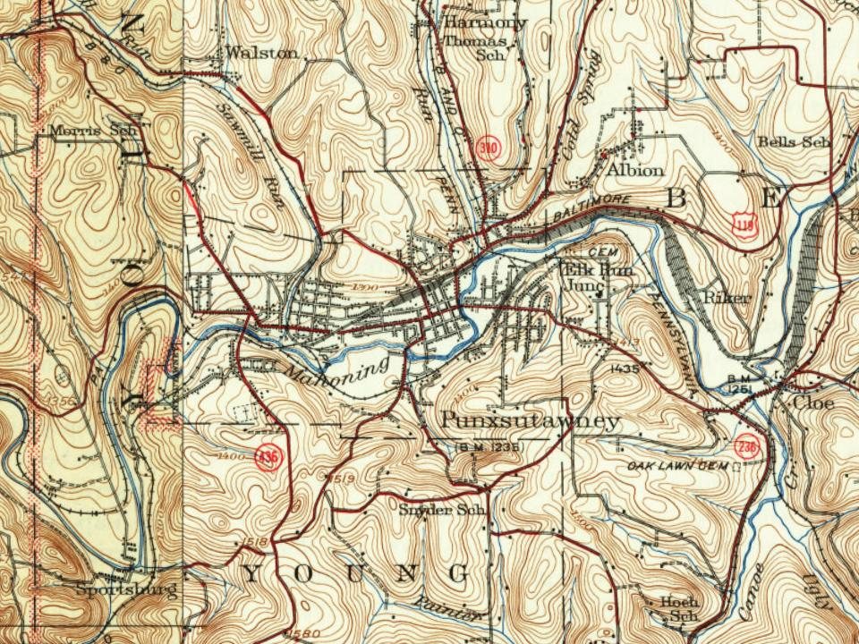
Founding dates: Wikidata, Wikipedia, the U.S. post office records of Blevins & Helbock (CC0) and the Census. Homes by year built: Census ACS 2020–24. National Register of Historic Places: National Park Service (list of May 22, 2026). Old photos, postcards and papers: Wikimedia Commons, the Library of Congress and other public archives, credited on each item’s page. Maps: U.S. Geological Survey historical topographic maps (via Esri) and Sanborn fire-insurance maps (Library of Congress). History text and census tables: Wikipedia (CC BY-SA 4.0). Places that used to be: USGS Geographic Names Information System (2021).
From Wikimedia Commons (2), the Library of Congress (10), the National Register of Historic Places (4), Wikipedia, Wikidata and Wikipedia for famous people, U.S. Geological Survey historical maps, U.S. Census counts (via Wikipedia), the US Post Offices dataset (Blevins & Helbock), the USGS Geographic Names Information System, Sanborn fire insurance maps (Library of Congress) and old county and town histories (Internet Archive). Archive images are copied here with their credits and licenses, shown on each photo’s page. Refreshed monthly.




 1906
 1906
 1906
 1920
 1920
 1920
 1940


