Pottsville dates to 1806, and 54% of its homes were built before 1940
More historic than 98% of U.S. towns · #65 of 1,035 in Pennsylvania. What drives it
7 places in town are on the National Register, among them a historic district with 336 buildings. Below: 17 old photos and papers, maps from 1885 on, and the census since 1830.
Founding year: Wikidata. First post office: 1825.The full story ↓
History grade
What drives Pottsville’s History grade
On its age, its old homes and the National Register, Pottsville is more historic than 98% of U.S. towns, #65 of 1,035 in Pennsylvania. All 3 inputs are above most U.S. towns; its share of homes from before 1940 ranks highest and its age lowest.
A+
HistoryA character grade: shown, never part of Pottsville’s overall grade.
Pennsylvania towns list about as much on the Register as the country (a typical Pennsylvania town has 2.1 per 10,000 residents, the U.S. 2.4), so Pottsville’s 263 sits above most of its state (92% of Pennsylvania towns have fewer) while its 352 historic buildings outnumber those of 96% of U.S. towns.
How sure. Graded on any two of the three inputs instead, the letter would range from A to A+. The pre-1940 share is a Census survey estimate (±5.6 points). Two sources give 1806.
Founding year: Wikidata (other dates in Quick answers). Homes: Census ACS 2020–24. National Register: National Park Service, May 2026 list; each listing counted once (boundary changes and added documentation belong to their listing), and a historic district counts its contributing buildings. How TownRatings grades history →
What stands out about Pottsville’s past
Read from the archive, the National Register and the record. The page puts what stands out first.
King Charles II granted the land that would eventually become Pottsville to William Penn. This grant comprised all lands west and south of the Delaware and Schuylkill Rivers; present-day Pottsville was originally in Chester County. When the legislative Council, on May 10, 1729, enacted the law erecting Lancaster County, which included all the lands of the Province lying westward of a straight line drawn northeasterly from the headwaters of Octoraro Creek (near the southern borders) marked with blazed trees, to the Schuylkill River, then this placed Pottsville in Lancaster County. By enactment of the same Council, approved on March 11, 1752, Berks County was erected; this placed Pottsville within the limits of that county.
Of these, it connects with the Mount Carbon Railroad, and the Mount Carbon and Port Carbon Railroad, at Mount Carbon one mile below Pottsville, and with the Mine Hill Railroad and its numerous radiating branches, at Schuylkill Haven, (this road is about being extended to connect with the Shamokin Railroad, thus afibrding a connection with the Susquehanna, and passing through the great Mohanoy coal region : — it M'ill thus bring an incalculable amount of additional tonnage and passengers to the Reading Railroad) also at
Text read by machine from the scan; it may contain errors.
miles. From insufficient means, this company was unable to extend their road, and yielded their right and charter to the Reading Railroad Company, who, with a further extension of their charter, ]>eyond Port Clinton to Pottsville, went into an active prosecution of the whole work, from Pottsville to the Delaware, ninety-four miles, under one charter, now known as the Reading Railroad.
Text read by machine from the scan; it may contain errors.
Blue book of Schuylkill County1916 · page 136Read the page →
Read the text
out in 1770. (Colonel Jacob Morgan was the great grandfather of the Misses Douglass, of Orwigsburg, and the great great grandfather of George, Frank and Clement Roseberry, of Pottsville. Miss Holt, teacher in the public schools, Pottsville, and others are also descendants.) (Note 1— Daniel Rupp's History of Berks County, p. 229.)
Text read by machine from the scan; it may contain errors.
Scans and text from the Internet Archive. Books published in 1930 or earlier, which are in the public domain.
Timeline
Pottsville, 1806 to 1976
Woven from the archive, old maps, post office records, the National Register and the people born here.
Nothing in the archives for these yearsWeddings on Main Street, storms, parades, school pictures, the old store. If it’s in your family album, it belongs here.
Fire insurance maps drew every building, what it was made of and what it was used for, so insurers could price the risk of fire. Pick a year, then a sheet.
In 1806, according to Wikidata. Pottsville’s post office opened in 1825, and the census of 1830 counted 2,464 people here.
How does Pottsville rank for history?
Pottsville is more historic than 98% of U.S. towns, #65 of 1,035 in Pennsylvania. The History grade combines the town’s founding era, the share of homes built before 1940 and its National Register listings. It’s a character grade, so it isn’t part of the overall grade. How it works.
What is on the National Register in Pottsville?
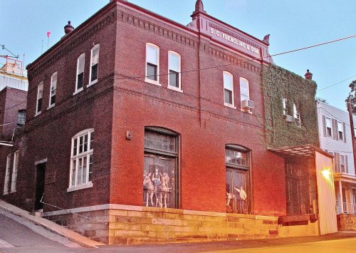
7 listings: 6 buildings, among them the Cloud Home (listed 1978, the first), and 1 historic district, the Pottsville Downtown Historic District, with 336 contributing buildings. 352 historic buildings in all.
How old are the homes in Pottsville?
54% of Pottsville’s homes were built before 1940 (Census estimate, ±5.6 points), against a typical 18% for a Pennsylvania town; the median home was built in 1938.
Founding dates: Wikidata, Wikipedia, the U.S. post office records of Blevins & Helbock (CC0) and the Census. Homes by year built: Census ACS 2020–24. National Register of Historic Places: National Park Service (list of May 22, 2026). Old photos, postcards and papers: Wikimedia Commons, the Library of Congress and other public archives, credited on each item’s page. Maps: U.S. Geological Survey historical topographic maps (via Esri) and Sanborn fire-insurance maps (Library of Congress). History text and census tables: Wikipedia (CC BY-SA 4.0). Places that used to be: USGS Geographic Names Information System (2021).
From Wikimedia Commons (4), the Library of Congress (13), the National Register of Historic Places (7), Wikipedia, Wikidata and Wikipedia for famous people, U.S. Geological Survey historical maps, U.S. Census counts (via Wikipedia), the US Post Offices dataset (Blevins & Helbock), the USGS Geographic Names Information System, Sanborn fire insurance maps (Library of Congress) and old county and town histories (Internet Archive). Archive images are copied here with their credits and licenses, shown on each photo’s page. Refreshed monthly.




![miles. From insufficient means, this company was unable to extend their road, and yielded their right and charter to the Reading Railroad Company, who, with a further extension of their charter, ]>eyond Port Clinton to Pottsville, went into an active prosecution of the whole work, from Pottsville t…](https://images.townratings.com/story/15491/bk-4527d5ebe6d90893-l.jpg)


 1833
 1833
 1854
 1855
 1855
 1890
 1905
 1905
 1905
 1905
 1905
