Its Register listings are the Fleisher Covered Bridge and the Bridge in Newport Borough. Below: 2 old photos and papers, maps from 1907 on, and old-book passages.
On its age, its old homes and the National Register, Oliver Township is more historic than 81% of U.S. towns. All 3 inputs are above most U.S. towns; its age ranks highest and its share of homes from before 1940 lowest.
A−
HistoryA character grade: shown, never part of Oliver Township’s overall grade.
Pennsylvania towns list about as much on the Register as the country (a typical Pennsylvania town has 2.1 per 10,000 residents, the U.S. 2.4), so Oliver Township’s 11.4 sits above most of its state (78% of Pennsylvania towns have fewer) while its 2 listings outnumber those of 60% of U.S. towns.
NoteThe founding year comes from Wikidata alone; no second source gives 1788.
How sure. Graded on any two of the three inputs instead, the letter would range from B+ to A−. The pre-1940 share is a Census survey estimate (±5.8 points).
Founding year: Wikidata (other dates in Quick answers). Homes: Census ACS 2020–24. National Register: National Park Service, May 2026 list; each listing counted once (boundary changes and added documentation belong to their listing), and a historic district counts its contributing buildings. How TownRatings grades history →
What stands out about Oliver Township’s past
Read from the archive, the National Register and the record. The page puts what stands out first.
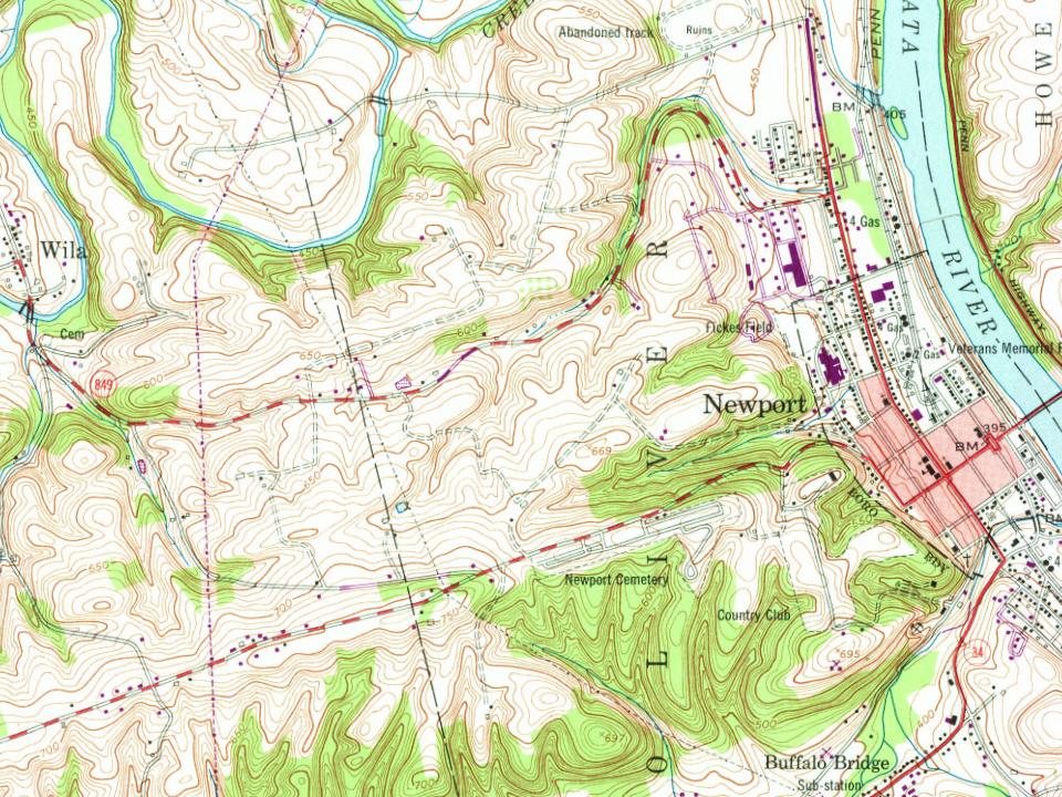
Every edition of the U.S. Geological Survey’s map of Oliver Township. Tap a year, or press play to watch the town change.
1907New Bloomfield sheet · 1:62,500
U.S. Geological Survey historical topographic maps (public domain), via Esri’s collection of the scans. The red ring marks the center of Oliver Township.
Timeline
Oliver Township, 1788 to 1982
Woven from the archive, old maps, post office records, the National Register and the people born here.
Passages that mention Oliver Township, cut from the printed page as they were published.
History of Perry County, Pennsylvania, including descriptions of Indians and pioneer life from the time of earliest settlement1922 · page 1041Read the page →
Read the text
Mt. Olivet Church of the Brethren. A number of members of the Church of tbe Brethren formerly known as German Baptists, residing in northern Oliver Township, first held meeting in their homes, and later on in the schoolhouse. When the Methodists at New Buffalo built their new church, the members of the Church of the Brethren in Oliver Township purchased the old building, razed it and removed it to a site west of Newport, opposite Alt. l''aiiview schoolhouse. It was dedicated January 3, 1915.
Text read by machine from the scan; it may contain errors.
History Of Perry County, Pennsylvania1922 · page 1032Read the page →
Read the text
This church was connected with the New Bloomfield charge until 1868, when a separate pastorate was formed, of which it was the head, the other churches being St. Samuel’s, in Oliver Township, and the Lutheran Church in Buck’s Valley. This church belongs to the Synod of Central Pennsylvania and was the first church in that synod to have a pipe organ, which it had installed as early as 1885. This was also the first pipe organ in Perry County. The ministers have been: 1876-81—Rev. M. Colver.
Text read by machine from the scan; it may contain errors.
History Of Perry County, Pennsylvania1922 · page 1036Read the page →
Read the text
Oliver Township is bounded on the north by Tuscarora, on the east by the Juniata River, which it borders for about six miles between the Tuscarora line and the great bend in the river between Newport and Bailey’s Station; on the south by Miller Township, and on the west by Centre and Juniata. It is one of the smaller townships in the county, its area being less than twenty square miles. Newport Borough lies within its borders.
Text read by machine from the scan; it may contain errors.
History of Perry County, Pennsylvania, including descriptions of Indians and pioneer life from the time of earliest settlement1922 · page 1038Read the page →
Read the text
Oliver Township is bounded on the north by Tuscarora, on the east by the Juniata River, which it borders for about six miles between the Tuscarora line and the great bend in the river between Newport and Bailey's Station ; on the south by Miller Township, and on the west by Centre and Juniata. It is one of the smaller townships in the county, its area being less than twenty square miles. Newport Borough lies within its borders.
Text read by machine from the scan; it may contain errors.
Scans and text from the Internet Archive. Books published in 1930 or earlier, which are in the public domain.
By decade
Oliver Township, decade by decade
2 decades in the archive, from the 1850s to the 1980s. Scroll each row; tap a photo for its story.
Nothing in the archives for these yearsWeddings on Main Street, storms, parades, school pictures, the old store. If it’s in your family album, it belongs here.
Oliver Township is more historic than 81% of U.S. towns. The History grade combines the town’s founding era, the share of homes built before 1940 and its National Register listings. It’s a character grade, so it isn’t part of the overall grade. How it works.
What is on the National Register in Oliver Township?
Two places: the Fleisher Covered Bridge (listed 1980) and the Bridge in Newport Borough (1988).
How old are the homes in Oliver Township?
16% of Oliver Township’s homes were built before 1940 (Census estimate, ±5.8 points), against a typical 18% for a Pennsylvania town; the median home was built in 1970.
Founding dates: Wikidata, Wikipedia, the U.S. post office records of Blevins & Helbock (CC0) and the Census. Homes by year built: Census ACS 2020–24. National Register of Historic Places: National Park Service (list of May 22, 2026). Old photos, postcards and papers: Wikimedia Commons, the Library of Congress and other public archives, credited on each item’s page. Maps: U.S. Geological Survey historical topographic maps (via Esri) and Sanborn fire-insurance maps (Library of Congress). History text and census tables: Wikipedia (CC BY-SA 4.0). Places that used to be: USGS Geographic Names Information System (2021).
From Wikimedia Commons (6), the National Register of Historic Places (2), Wikipedia, U.S. Geological Survey historical maps, the USGS Geographic Names Information System and old county and town histories (Internet Archive). Archive images are copied here with their credits and licenses, shown on each photo’s page. Refreshed monthly.




 2011
 2011
 2011
 2011


