Founding year: Wikidata; Wikipedia’s history section gives the same year. First post office: 1805.The full story ↓
History grade
What drives New Oxford’s History grade
On its age, its old homes and the National Register, New Oxford is more historic than 68% of U.S. towns. Its share of homes from before 1940 holds the grade up; its National Register listings pull it down.
B+
HistoryA character grade: shown, never part of New Oxford’s overall grade.
Pennsylvania towns list about as much on the Register as the country (a typical Pennsylvania town has 2.1 per 10,000 residents, the U.S. 2.4), so New Oxford’s 0.0 sits below most of its state (25% of Pennsylvania towns have fewer) while its 0 listings outnumber those of 23% of U.S. towns.
How sure. Graded on any two of the three inputs instead, the letter would range from B− to A. The pre-1940 share is a Census survey estimate (±5.7 points). Two sources give 1792.
Founding year: Wikidata (other dates in Quick answers). Homes: Census ACS 2020–24. National Register: National Park Service, May 2026 list; each listing counted once (boundary changes and added documentation belong to their listing), and a historic district counts its contributing buildings. How TownRatings grades history →
What stands out about New Oxford’s past
Read from the archive, the National Register and the record. The page puts what stands out first.
New Oxford was originally platted in 1792 for Henry Kuhn by James Bolton and identified as "Oxford town" due to the presence of a nearby stream ford and a local establishment named "Dutch Frederick's stand" with the head of an ox on the front of the building. This was changed again in 1822 by the town's first postmaster, Dr. Pfeiffer to "New Oxford". New Oxford was incorporated as borough on August 20, 1874, and Joseph S. Gitt was elected as its first president and then served as secretary through 1891. In 1886, the population was 209, with 67 horses, 40 cattle, 65 "pleasure carriages", and 14 gold watches.
Passages that mention New Oxford, cut from the printed page as they were published.
history of adams county pennsylvania.1886 · page 324Read the page →
Read the text
Railroads were projected in this vicinity as early as 1835, for in that year Dr. Pfeiffer managed a line from York to Gettysburg via New Oxford. In January 6, 1858, the railroad from Hanover to New Oxford was opened. The Hanover Branch Railroad, consolidated under the name of Hanover Junction, Hanover & Gettysburg Railroad, took place in November, 1874, when A. W.
Text read by machine from the scan; it may contain errors.
history of adams county pennsylvania.1886 · page 492Read the page →
Read the text
Qeorge, Jacob, Klizabeth Golden, Sarah Blair, Mary Albert and Susan Diller. This family moved into Adams County, Penn., in all probability about the year 1801, settling in Oxford Township, having purchased a large tract of land lying along the Gettysburg Turnpike and reaching from the village of New Oxford to the banks of the Litthke Conowago, embracing several hundred acres of choice laud. Mr. Diehl paid half a bushel of silver for the tract, and brought the money from Hellam Township to New Oxford in saddle-bags, thrown across the back of his horse, It is said the animal presented asad sight, having been sorcly blistered by the weight and friction of the coin. Daniel was born in the old
Text read by machine from the scan; it may contain errors.
Scans and text from the Internet Archive. Books published in 1930 or earlier, which are in the public domain.
By decade
New Oxford, decade by decade
2 decades in the archive, from the 1930s to the 1990s. Scroll each row; tap a photo for its story.
Nothing in the archives for these yearsWeddings on Main Street, storms, parades, school pictures, the old store. If it’s in your family album, it belongs here.
Fire insurance maps drew every building, what it was made of and what it was used for, so insurers could price the risk of fire. Pick a year, then a sheet.
In 1792, according to Wikidata and Wikipedia’s history of the town. New Oxford’s post office opened in 1805, and the census of 1840 counted 225 people here.
How does New Oxford rank for history?
New Oxford is more historic than 68% of U.S. towns. The History grade combines the town’s founding era, the share of homes built before 1940 and its National Register listings. It’s a character grade, so it isn’t part of the overall grade. How it works.
How old are the homes in New Oxford?
28% of New Oxford’s homes were built before 1940 (Census estimate, ±5.7 points), against a typical 18% for a Pennsylvania town; the median home was built in 1968.
Founding dates: Wikidata, Wikipedia, the U.S. post office records of Blevins & Helbock (CC0) and the Census. Homes by year built: Census ACS 2020–24. National Register of Historic Places: National Park Service (list of May 22, 2026). Old photos, postcards and papers: Wikimedia Commons, the Library of Congress and other public archives, credited on each item’s page. Maps: U.S. Geological Survey historical topographic maps (via Esri) and Sanborn fire-insurance maps (Library of Congress). History text and census tables: Wikipedia (CC BY-SA 4.0). Places that used to be: USGS Geographic Names Information System (2021).
From Wikimedia Commons (6), Wikipedia, Wikidata and Wikipedia for famous people, U.S. Geological Survey historical maps, U.S. Census counts (via Wikipedia), the US Post Offices dataset (Blevins & Helbock), the USGS Geographic Names Information System, Sanborn fire insurance maps (Library of Congress) and old county and town histories (Internet Archive). Archive images are copied here with their credits and licenses, shown on each photo’s page. Refreshed monthly.


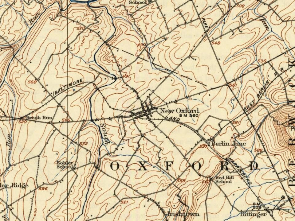




 c. 1930
 1999
 1999
 1999
