Nazareth dates to 1740, and 54% of its homes were built before 1940
Among the most historic 1% of U.S. towns · #8 of 1,035 in Pennsylvania. What drives it
5 places in town are on the National Register, among them a historic district with 503 buildings. Below: 10 old photos and papers, maps from 1894 on, and the census since 1860.
Founding year: Wikidata; Wikipedia’s history section gives the same year. First post office: 1802.The full story ↓
History grade
What drives Nazareth’s History grade
On its age, its old homes and the National Register, Nazareth is among the most historic 1% of U.S. towns, #8 of 1,035 in Pennsylvania. All 3 inputs put Nazareth near the top nationally; its share of homes from before 1940 ranks highest.
A+
HistoryA character grade: shown, never part of Nazareth’s overall grade.
Pennsylvania towns list about as much on the Register as the country (a typical Pennsylvania town has 2.1 per 10,000 residents, the U.S. 2.4), so Nazareth’s 846 sits above most of its state (97% of Pennsylvania towns have fewer) while its 511 historic buildings outnumber those of 97% of U.S. towns.
How sure. Graded on any two of the three inputs instead, the letter would still be A+. The pre-1940 share is a Census survey estimate (±7.0 points). Two sources give 1740.
Founding year: Wikidata (other dates in Quick answers). Homes: Census ACS 2020–24. National Register: National Park Service, May 2026 list; each listing counted once (boundary changes and added documentation belong to their listing), and a historic district counts its contributing buildings. How TownRatings grades history →
What stands out about Nazareth’s past
Read from the archive, the National Register and the record. The page puts what stands out first.
The borough is named for the Biblical town of Nazareth, where Jesus spent his youth. The names of a number of other places in the Lehigh Valley area of Pennsylvania are similarly inspired, including Bethlehem, Emmaus, Egypt, and Allentown's Jordan Creek.
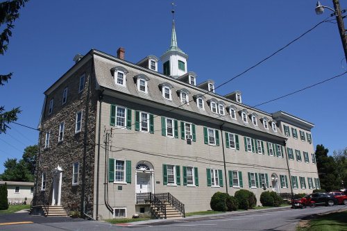
Nazareth was founded in 1740 by ethnically German Moravian immigrants. The property that comprises present-day Nazareth was purchased from George Whitefield after the construction of the Whitefield House.
Passages that mention Nazareth, cut from the printed page as they were published.
History of Northampton County [Pennsylvania] and the grand valley of the Lehigh under supervision and revision of William J. Heller, assisted by an advisory board of editors..1920 · page 51Read the page →
Read the text
old Edison Illuminating Company. In 1897, with the aid of New England capitalists, the Hay brothers built the first interurban street railway in this section, the line connecting Easton and Bethlehem. In 1898 they organized a company to build the line from Easton to Nazareth and from Nazareth to Bangor, and the same year began the construction of the Easton and Nazareth line, completing it in 1901. The Easton, Tatamy and Bangor street line was begun in 1902 and in 1903 being completed was consolidated with the Easton and Nazareth line as the Northampton Traction Company, the consolidated
Text read by machine from the scan; it may contain errors.
History of Northampton County [Pennsylvania] and the grand valley of the Lehigh under supervision and revision of William J. Heller, assisted by an advisory board of editors..1920 · page 499Read the page →
Read the text
Nazareth ; and on the west by East Allen township. The first census returns of Upper Nazareth gave its population as 663, which had increased in 1850 to 1,116; all these figures include the village of Nazareth. In that year there were 181 farms; 158 dwelling houses, of which sixty-one were in the village, and 186 families, of which number 83 were inhabitants of the village.
Text read by machine from the scan; it may contain errors.
with the other elements of the population that had taken root in the Prgvince, and that were crowding them in their exclusive settlements. The Economy at Nazareth was dissolved in 1764. This led to many changes ; the most important of which were the concentration of their people on fewer farms, and the subsequent founding of the village, now the borough, of Nazareth. This was laid out on a parcel
Text read by machine from the scan; it may contain errors.
skins and wooden ware for strouds and half-thicks, and powder and lead. Mr. Edmonds relinquished his position at The Rose in 1772 — was appointed shop-keeper in the village of Nazareth, and deceased there in September of 1786. Several allusions having been made in the course of this narrative to the Rose-farm, it may be well to dispossess the reader of any erroneous precon-
Text read by machine from the scan; it may contain errors.
Scans and text from the Internet Archive. Books published in 1930 or earlier, which are in the public domain.
Timeline
Nazareth, 1740 to 2000
Woven from the archive, old maps, post office records, the National Register and the people born here.
Nothing in the archives for these yearsWeddings on Main Street, storms, parades, school pictures, the old store. If it’s in your family album, it belongs here.
Fire insurance maps drew every building, what it was made of and what it was used for, so insurers could price the risk of fire. Pick a year, then a sheet.
In 1740, according to Wikidata and Wikipedia’s history of the town. Nazareth’s post office opened in 1802, and the census of 1860 counted 781 people here.
How does Nazareth rank for history?
Nazareth is among the most historic 1% of U.S. towns, #8 of 1,035 in Pennsylvania. The History grade combines the town’s founding era, the share of homes built before 1940 and its National Register listings. It’s a character grade, so it isn’t part of the overall grade. How it works.
What is on the National Register in Nazareth?
5 listings: 4 buildings, among them the Whitefield House and Gray Cottage (listed 1980, the first), and 1 historic district, the Nazareth Historic District, with 503 contributing buildings. 511 historic buildings in all.
How old are the homes in Nazareth?
54% of Nazareth’s homes were built before 1940 (Census estimate, ±7.0 points), against a typical 18% for a Pennsylvania town; the median home was built in 1938.
Founding dates: Wikidata, Wikipedia, the U.S. post office records of Blevins & Helbock (CC0) and the Census. Homes by year built: Census ACS 2020–24. National Register of Historic Places: National Park Service (list of May 22, 2026). Old photos, postcards and papers: Wikimedia Commons, the Library of Congress and other public archives, credited on each item’s page. Maps: U.S. Geological Survey historical topographic maps (via Esri) and Sanborn fire-insurance maps (Library of Congress). History text and census tables: Wikipedia (CC BY-SA 4.0). Places that used to be: USGS Geographic Names Information System (2021).
From Wikimedia Commons (20), the Library of Congress (8), Wikidata (1), the National Register of Historic Places (5), Wikipedia, Wikidata and Wikipedia for famous people, U.S. Geological Survey historical maps, U.S. Census counts (via Wikipedia), the US Post Offices dataset (Blevins & Helbock), the USGS Geographic Names Information System, Sanborn fire insurance maps (Library of Congress) and old county and town histories (Internet Archive). Archive images are copied here with their credits and licenses, shown on each photo’s page. Refreshed monthly.




 1850
 1933
 Date?
 Date?
 Date?
 Date?
 2019
 2019
 2019
 2019
 2015
 2013
 2013
 2013
 2013
 2013
 2013
 2013
 2012
 2012
 2012
 2012
 2012
 2009

