From Mount Oliver’s archive · credits on each photo
Quick answers
How Mount Oliver began
When was Mount Oliver founded?
1874
The Mount Oliver post office opened in 1874, the earliest record of the town by name. Wikidata gives 1892. Another post office, Ormsby (1861), opened inside today’s town and later closed.
First census: 1,883 in 18802020 census: 3,394152 years
How historic is Mount Oliver?
B
More historic than 56% of U.S. towns, on its age, its old homes and the National Register.
Founding year: the first Mount Oliver post office (Blevins & Helbock, CC0). Wikidata: 1892.The full story ↓
History grade
What drives Mount Oliver’s History grade
On its age, its old homes and the National Register, Mount Oliver is more historic than 56% of U.S. towns, #659 of 1,035 in Pennsylvania. Its share of homes from before 1940 holds the grade up; its National Register listings pull it down.
B
HistoryA character grade: shown, never part of Mount Oliver’s overall grade.
Pennsylvania towns list about as much on the Register as the country (a typical Pennsylvania town has 2.1 per 10,000 residents, the U.S. 2.4), so Mount Oliver’s 0.0 sits below most of its state (25% of Pennsylvania towns have fewer) while its 0 listings outnumber those of 23% of U.S. towns.
How sure. Graded on any two of the three inputs instead, the letter would range from C− to B+. The pre-1940 share is a Census survey estimate (±12.4 points). The founding year is the first post office, not a stated founding date; Wikidata’s 1892 falls in the same era, so the grade doesn’t depend on which one is used.
Founding year: the first post office (other dates in Quick answers). Homes: Census ACS 2020–24. National Register: National Park Service, May 2026 list; each listing counted once (boundary changes and added documentation belong to their listing), and a historic district counts its contributing buildings. How TownRatings grades history →
What stands out about Mount Oliver’s past
Read from the archive, the National Register and the record. The page puts what stands out first.
Mount Oliver was first settled by John Ormsby, an officer in the command of General Forbes, who was granted 249 acres of land along the banks of the Monongahela River. In 1788 Allegheny County was divided into townships, with Ormsby's plot being part of St. Clair Township. In 1800 Ormsby began selling parcels of land, while retaining rent and property taxes from residents. Ormsby named his growing settlement Mount Oliver, after his son, Oliver Ormsby. Later that year St. Clair Township would be divided with residents attempting to incorporate as a borough, however, the state ruled against the effort stating that the property owner quota was not sufficient to award incorporation, and Mount Oliver would become part of Lower St. Clair Township.
Peaked at 7,071 in 1930; 3,394 people lived here in 2020.
14 censuses, 1880–2020.
U.S. Census Bureau decennial counts, from the census table on Mount Oliver’s Wikipedia page.
On the map
Mount Oliver on the map, 1904 to 1993
Every edition of the U.S. Geological Survey’s map of Mount Oliver. Tap a year, or press play to watch the town change.
1904Pittsburgh sheet · 1:62,500
U.S. Geological Survey historical topographic maps (public domain), via Esri’s collection of the scans. The red ring marks the center of Mount Oliver.
From the old history books
What they wrote about Mount Oliver in 1889
Passages that mention Mount Oliver, cut from the printed page as they were published.
History of Allegheny county, Pennsylvania1889 · page 628Read the page →
Read the text
On the outside of the city, on the South Side, are the boroughs of Knoxville and Beltzhoover and the village of Mount Oliver, and on the East End, Wilkinsburg, all nearly, if not quite, ready to drop into the city's arms. It need not sui'prise anyone if the city lines soon extend from Beck's run, on the Monongahela, to Chartiers creek, and take in the bulk of Chartiers township. Green Tree, Knoxville, Beltzhoover, and what is left of Lower St. Clair township, on the South Side, and Sterrett township on the east. The heavy indebtedness of the city is the only drawback; but this will gradually diminish, and with it
Text read by machine from the scan; it may contain errors.
History of Allegheny county, Pennsylvania1889 · page 626Read the page →
Read the text
On the outside of the city, on the South Side, are the boroughs of Knoxville and Beltzhoover and the village of Mount Oliver, and on the East End, Wilkinsburg, all nearly, if not quite, ready to drop into the city’ s arms. It need not surprise anyone if the city lines soon extend from Beck’s run, on the Monongahela, to Chartiers creek, and take in the bulk of Chartiers township, Green Tree, Knoxville, Beltzhoover, and what is left of Lower St. Clair township, on the South Side, and Sterrett township on the east. The heavy indebtedness of the city is the only drawback; but this will gradually diminish, and with it
Text read by machine from the scan; it may contain errors.
Scans and text from the Internet Archive. Books published in 1930 or earlier, which are in the public domain.
Timeline
Mount Oliver, 1861 to 1966
Woven from the archive, old maps, post office records, the National Register and the people born here.
Nothing in the archives for these yearsWeddings on Main Street, storms, parades, school pictures, the old store. If it’s in your family album, it belongs here.
The Mount Oliver post office opened in 1874, the earliest record of the town by name (U.S. post office records). Wikidata gives 1892.
How does Mount Oliver rank for history?
Mount Oliver is more historic than 56% of U.S. towns, #659 of 1,035 in Pennsylvania. The History grade combines the town’s founding era, the share of homes built before 1940 and its National Register listings. It’s a character grade, so it isn’t part of the overall grade. How it works.
How old are the homes in Mount Oliver?
54% of Mount Oliver’s homes were built before 1940 (Census estimate, ±12.4 points), against a typical 18% for a Pennsylvania town; the median home was built in 1938.
Founding dates: Wikidata, Wikipedia, the U.S. post office records of Blevins & Helbock (CC0) and the Census. Homes by year built: Census ACS 2020–24. National Register of Historic Places: National Park Service (list of May 22, 2026). Old photos, postcards and papers: Wikimedia Commons, the Library of Congress and other public archives, credited on each item’s page. Maps: U.S. Geological Survey historical topographic maps (via Esri) and Sanborn fire-insurance maps (Library of Congress). History text and census tables: Wikipedia (CC BY-SA 4.0). Places that used to be: USGS Geographic Names Information System (2021).
From Wikimedia Commons (6), Wikipedia, Wikidata and Wikipedia for famous people, U.S. Geological Survey historical maps, U.S. Census counts (via Wikipedia), the US Post Offices dataset (Blevins & Helbock), the USGS Geographic Names Information System and old county and town histories (Internet Archive). Archive images are copied here with their credits and licenses, shown on each photo’s page. Refreshed monthly.


 1968
 1968
 1968
 1968
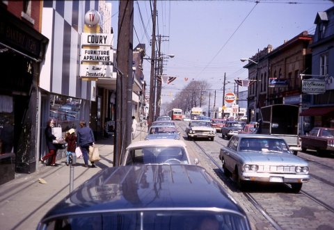 1968