


The story
Read it all →How Marysville came to be
From Wikipedia’s history of Marysville.
The Rockville Bridge was added to the National Register of Historic Places in 1975.
Text from Wikipedia, licensed CC BY-SA 4.0.
Each edition grades its towns against each other only.
 Photo: Dincher · CC BY-SA 3.0
More historic than 83% of U.S. towns · #278 of 1,035 in Pennsylvania. What drives it
Below: 1 old photo or paper, maps from 1892 on, and the census since 1870.
Marysville dates its founding to 1755 (Wikidata and Wikipedia’s history agree). The census first counted it in 1870.
More historic than 83% of U.S. towns, on its age, its old homes and the National Register.
On its age, its old homes and the National Register, Marysville is more historic than 83% of U.S. towns, #278 of 1,035 in Pennsylvania. Its age holds the grade up; its National Register listings pull it down.
Pennsylvania towns list about as much on the Register as the country (a typical Pennsylvania town has 2.1 per 10,000 residents, the U.S. 2.4), so Marysville’s 0.0 sits below most of its state (25% of Pennsylvania towns have fewer) while its 0 listings outnumber those of 23% of U.S. towns.
Founding year: Wikidata (other dates in Quick answers). Homes: Census ACS 2020–24. National Register: National Park Service, May 2026 list; each listing counted once (boundary changes and added documentation belong to their listing), and a historic district counts its contributing buildings. How TownRatings grades history →
Read from the archive, the National Register and the record. The page puts what stands out first.
The first neighbors to add old photos shape how Marysville’s history is told.
Every edition of the U.S. Geological Survey’s map of Marysville. Tap a year, or press play to watch the town change.

U.S. Geological Survey historical topographic maps (public domain), via Esri’s collection of the scans. The red ring marks the center of Marysville.
Woven from the archive, old maps, post office records, the National Register and the people born here.
 In the archive1940 Census Enumeration District Descriptions - Pennsylvania - Perry County - ED 50-12, E…
 On the mapFirst mapped by the U.S. Geological Survey
From Wikipedia’s history of Marysville.
The Rockville Bridge was added to the National Register of Historic Places in 1975.
Text from Wikipedia, licensed CC BY-SA 4.0.
Passages that mention Marysville, cut from the printed page as they were published.

Marysville, with its extensive railroad yards, in 1862 had but a watering station for engines, called the "Y." In 1863 the wooden railroad bridge connecting the town of Dauphin and northern Marysville, was built, thus connecting the divisions of the Northern Central Railroad from Baltimore to the North. The northbound and southbound traffic then all passed through Marysville. The station at the west end of this bridge was known as Marysville, and the lower station, at the then village proper, as Haley's.
Text read by machine from the scan; it may contain errors.
Marysville, with its extensive railroad yards, in 1862 had but a watering station for engines, called the “Y.’ In 1863 the wooden railroad bridge connecting the town of Dauphin and northern Marysville, was built, thus connecting the divisions of the Northern Central Railroad from Baltimore to the North. The northbound and southbound traffic then all passed through Marysville. The station at the west end of this bridge was known as Marysville, and the lower station, at the then village proper, as Haley’s.
Text read by machine from the scan; it may contain errors.
Marysville was laid out by Theophilus Fenn, the proprietor of the land on which it is built, as a village of Rye township, and up to April 12, 1866, was never incorporated, when it was incorporated as Haley, which was the name given to the post-office for a year or more. Since its incorporation, Marysville has improved so rapidly that it now ranks third in the county in number of population.
Text read by machine from the scan; it may contain errors.
Marysville Church of God. Rev. Thomas Still organized the first church of that faith in Marysville, in 1866, following a series of religious meetings held in the woods. It began with eight members. As early as 1850 several meetings were held, but with no result, as there were then but four dwelling houses there. In 1865 another effort was made, but again lapsed.
Text read by machine from the scan; it may contain errors.Scans and text from the Internet Archive. Books published in 1930 or earlier, which are in the public domain.
One decade in the archive so far: the 1850s. Scroll each row; tap a photo for its story.
 2026North Main Street nb, Marysville, PA, May 2026
 2026Marysville, PA from Fort Hunter, May 2026
 2026Front Street eb inside Marysville, PA subway, May 2026
 2026Front Street eb entering Marysville, PA subway, May 2…
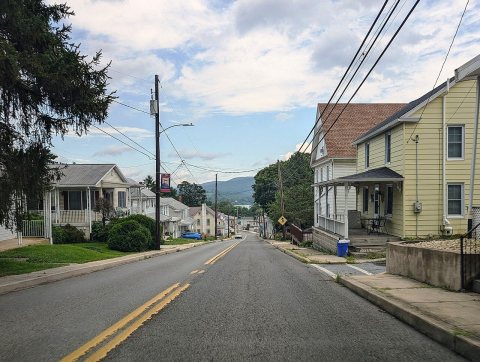 2025PA 850, Marysville (2), July 2025
 2025PA 850, Marysville (1), July 2025
 2025PA 850 eb entering Marysville, July 2025
 2025Marysville-Rye Library, Marysville, PA, July 2025
 2025Marysville, PA Municipal Building, July 2025
 2024PA 850 WB past US 11-US 15
 2023US 11-15 sb approaching PA 850, Aug. 2023
 2022Cove Mountain Preserve
 20222022-09-09 17 34 05 UTC minus 4 Aerial view centered …
 2010Marysville, PA
Fire insurance maps drew every building, what it was made of and what it was used for, so insurers could price the risk of fire. Pick a year, then a sheet.
 1905Sheet 1 of 4
Sanborn Map Company, via the Library of Congress. Editions published in 1930 or earlier, which are in the public domain.
No then-and-now pairs yet. Take a photo from the same spot as an old one and they appear here side by side.

Find the spot, match the angle, and add your photo. It becomes the first then-and-now pair on Marysville’s page.
Retake this view · +15Grew from 863 people in 1870 to 2,652 in 2020, 3 times over.
16 censuses, 1870–2020.
U.S. Census Bureau decennial counts, from the census table on Marysville’s Wikipedia page.
Each neighbor’s History grade, on the same three inputs.
In 1755, according to Wikidata and Wikipedia’s history of the town. Marysville’s post office opened in 1867, and the census of 1870 counted 863 people here.
Marysville is more historic than 83% of U.S. towns, #278 of 1,035 in Pennsylvania. The History grade combines the town’s founding era, the share of homes built before 1940 and its National Register listings. It’s a character grade, so it isn’t part of the overall grade. How it works.
38% of Marysville’s homes were built before 1940 (Census estimate, ±7.7 points), against a typical 18% for a Pennsylvania town; the median home was built in 1955.
What the archives can’t tell you, neighbors can.
Founding dates: Wikidata, Wikipedia, the U.S. post office records of Blevins & Helbock (CC0) and the Census. Homes by year built: Census ACS 2020–24. National Register of Historic Places: National Park Service (list of May 22, 2026). Old photos, postcards and papers: Wikimedia Commons, the Library of Congress and other public archives, credited on each item’s page. Maps: U.S. Geological Survey historical topographic maps (via Esri) and Sanborn fire-insurance maps (Library of Congress). History text and census tables: Wikipedia (CC BY-SA 4.0). Places that used to be: USGS Geographic Names Information System (2021).
From Wikimedia Commons (15), Wikipedia, U.S. Geological Survey historical maps, U.S. Census counts (via Wikipedia), the US Post Offices dataset (Blevins & Helbock), the USGS Geographic Names Information System, Sanborn fire insurance maps (Library of Congress) and old county and town histories (Internet Archive). Archive images are copied here with their credits and licenses, shown on each photo’s page. Refreshed monthly.