Jenkintown dates to 1697, and 59% of its homes were built before 1940
More historic than 93% of U.S. towns · #141 of 1,035 in Pennsylvania. What drives it
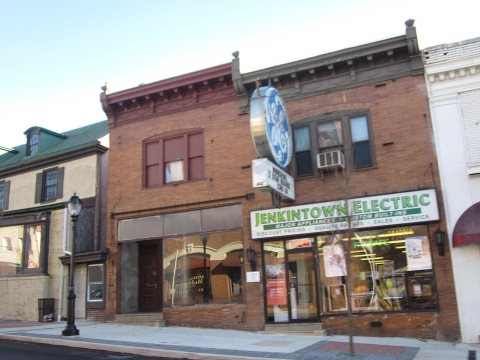
Its Register listings are the Jenkins' Town Lyceum Building and the Strawbridge and Clothier Store. Below: 6 old photos and papers, maps from 1893 on, and the census since 1880.
Founding year: Wikipedia. First post office: 1803.The full story ↓
History grade
What drives Jenkintown’s History grade
On its age, its old homes and the National Register, Jenkintown is more historic than 93% of U.S. towns, #141 of 1,035 in Pennsylvania. All 2 inputs are above most U.S. towns; its share of homes from before 1940 ranks highest and its National Register listings lowest.
A
HistoryA character grade: shown, never part of Jenkintown’s overall grade.
Pennsylvania towns list about as much on the Register as the country (a typical Pennsylvania town has 2.1 per 10,000 residents, the U.S. 2.4), so Jenkintown’s 4.2 sits above most of its state (65% of Pennsylvania towns have fewer) while its 2 listings outnumber those of 60% of U.S. towns.
NoteThe founding year comes from Wikipedia alone; no second source gives 1697.
How sure. Graded on two of the three inputs, so a change in either one moves the letter more than it would with three. The pre-1940 share is a Census survey estimate (±6.8 points).
Founding year: Wikipedia (other dates in Quick answers). Homes: Census ACS 2020–24. National Register: National Park Service, May 2026 list; each listing counted once (boundary changes and added documentation belong to their listing), and a historic district counts its contributing buildings. How TownRatings grades history →
What stands out about Jenkintown’s past
Read from the archive, the National Register and the record. The page puts what stands out first.
The community was named after William Jenkins, a Welsh pioneer settler.
The borough was settled in about 1697 and incorporated on December 8, 1874, when approximately 248 acres (1.00 km2) was taken from Abington Township. Today, the Borough is approximately 0.58 square miles (1.5 km2) and is home to 4,500 residents.
Elements of the British army passed through Jenkintown en route to the Battle of White Marsh in early December 1777.
From the mid-1950s until the early 1980s, Jenkintown was a major retail hub for the northern suburbs of Philadelphia.
Passages that mention Jenkintown, cut from the printed page as they were published.
History of Montgomery County, Pennsylvania1884 · page 977Read the page →
Read the text
Warminster in 1850. The North East Pennsylvania Railroad has two miles of road in this township, and has stations at Willow Grove, Heaton, Fulmor and Bonair. The branch extending from Jenkintown to New York, has a course of two miles and a half, and a station called Bethayres. The Newtown Railroad has three miles of track in the township witli stations at Huntingdon Valley and Byberry road. The
Text read by machine from the scan; it may contain errors.
A brief history of Montgomery County, Pennsylvania, with an accompanying map1923 · page 194Read the page →
Read the text
Abington township, one of the original townships, out of which Jenkintown was carved, is crossed near the middle by the York road. The village of Abington, an old settlement once known as Moorestown, is the place of worship of the Abington Presbyterian Church, founded 1714. In the cemetery by the roadside are the graves of Malachi Jones, the first pastor of the church, of Gilbert Tennent, of Samuel Finley, the fifth president of Princeton college, and other noted men of early days.
Text read by machine from the scan; it may contain errors.
Montgomery County, Pennsylvania1923 · page 366Read the page →
Read the text
The principal inhabitants in and around the village of Jenkintown as early as February 19, 1803, assembled for the purpose of establishing a library there, and appointed John Morrison, Ebenezer Hickling and William Johnson a committee for the purpose of preparing a code of by-laws and reporting the same at a meeting to be held at the public house of William McCalla on the 3rd of March following. As adopted the board of ofificers was to consist of five directors, a treasurer and librarian, to be chosen annually. Payments of seventy-five cents were
Text read by machine from the scan; it may contain errors.
History of Montgomery County, Pennsylvania1884 · page 736Read the page →
Read the text
The principal inhabitants in and around the village of Jenkintown as early as February 19, 1803, assembled for the purpose of establishing a library there, and appointed John Morrison, Ebenezer Hickliug and William Johnson a committee for the purpose of preparing a code of by-laws and reporting the same at a meeting to be held at the public-house of William McCalla on the 3d of March following at three p.m.
Text read by machine from the scan; it may contain errors.
Scans and text from the Internet Archive. Books published in 1930 or earlier, which are in the public domain.
By decade
Jenkintown, decade by decade
One decade in the archive so far: the 1890s. Scroll each row; tap a photo for its story.
Nothing in the archives for these yearsWeddings on Main Street, storms, parades, school pictures, the old store. If it’s in your family album, it belongs here.
In 1697, according to Wikipedia’s history of the town. Jenkintown’s post office opened in 1803, and the census of 1880 counted 810 people here.
How does Jenkintown rank for history?
Jenkintown is more historic than 93% of U.S. towns, #141 of 1,035 in Pennsylvania. The History grade combines the town’s founding era, the share of homes built before 1940 and its National Register listings. It’s a character grade, so it isn’t part of the overall grade. How it works.
What is on the National Register in Jenkintown?
Two places: the Jenkins' Town Lyceum Building (listed 1979) and the Strawbridge and Clothier Store (1988).
How old are the homes in Jenkintown?
59% of Jenkintown’s homes were built before 1940 (Census estimate, ±6.8 points), against a typical 18% for a Pennsylvania town; the median home was built in 1938.
Founding dates: Wikidata, Wikipedia, the U.S. post office records of Blevins & Helbock (CC0) and the Census. Homes by year built: Census ACS 2020–24. National Register of Historic Places: National Park Service (list of May 22, 2026). Old photos, postcards and papers: Wikimedia Commons, the Library of Congress and other public archives, credited on each item’s page. Maps: U.S. Geological Survey historical topographic maps (via Esri) and Sanborn fire-insurance maps (Library of Congress). History text and census tables: Wikipedia (CC BY-SA 4.0). Places that used to be: USGS Geographic Names Information System (2021).
From Wikimedia Commons (15), the Library of Congress (2), Wikidata (1), the National Register of Historic Places (2), Wikipedia, Wikidata and Wikipedia for famous people, U.S. Geological Survey historical maps, U.S. Census counts (via Wikipedia), the US Post Offices dataset (Blevins & Helbock), the USGS Geographic Names Information System, Sanborn fire insurance maps (Library of Congress) and old county and town histories (Internet Archive). Archive images are copied here with their credits and licenses, shown on each photo’s page. Refreshed monthly.


 1892
 1892
 1899
 1899
 1899
 2013
 2012
 2012
 2011
 2011
 2011
 2011
 2011
 2011
 2008
 2007


