Among the most historic 1% of U.S. towns · #10 of 1,035 in Pennsylvania. What drives it
2 places in town are on the National Register, among them a historic district with 380 buildings. Below: 18 old photos and papers, maps from 1888 on, and the census since 1810.
On its age, its old homes and the National Register, Franklin is among the most historic 1% of U.S. towns, #10 of 1,035 in Pennsylvania. All 2 inputs put Franklin near the top nationally; its share of homes from before 1940 ranks highest.
A+
HistoryA character grade: shown, never part of Franklin’s overall grade.
Pennsylvania towns list about as much on the Register as the country (a typical Pennsylvania town has 2.1 per 10,000 residents, the U.S. 2.4), so Franklin’s 638 sits above most of its state (95% of Pennsylvania towns have fewer) while its 382 historic buildings outnumber those of 96% of U.S. towns.
How sure. Graded on two of the three inputs, so a change in either one moves the letter more than it would with three. The pre-1940 share is a Census survey estimate (±5.7 points).
Founding year: our sources. Homes: Census ACS 2020–24. National Register: National Park Service, May 2026 list; each listing counted once (boundary changes and added documentation belong to their listing), and a historic district counts its contributing buildings. How TownRatings grades history →
What stands out about Franklin’s past
Read from the archive, the National Register and the record. The page puts what stands out first.
National Park Service, National Register of Historic Places. Photos from Wikimedia Commons, credited on each place’s page.
Every building
Franklin, building by building, 1888–1922
Fire insurance maps drew every building, what it was made of and what it was used for, so insurers could price the risk of fire. Pick a year, then a sheet.
Nothing in the archives for these yearsWeddings on Main Street, storms, parades, school pictures, the old store. If it’s in your family album, it belongs here.
Franklin is located at the confluence of French Creek and the Allegheny River, an important site used for centuries by Native Americans. They had long before developed what became known as the Venango Path, passing from the head of French Creek north to Presque Isle Bay on Lake Erie. Via French Creek and the Allegheny River, the portage effectively linked the waterways of the Ohio River and the Great Lakes.
In 1740, Scottish fur trader John Fraser built a trading post here at Venango, the Lenape village. The French also had designs on this region.
Passages that mention Franklin, cut from the printed page as they were published.
Historical sketch of Franklin County, Pennsylvania1878 · page 53Read the page →
Read the text
We have now three railroads in our county, viz. : The "Cumberland Valley," which embraces the old "Franklin Railroad," and extends through the valley from Harrisburg to the Maryland line, a distance of about sixty-eight miles; the "Mont Alto Railroad," twelve and thirty one-hundredths miles long; and the "Southern Pennsylvania Railway," twenty-one and four-tenth miles in length, making a total railroad mileage in the county of about fifty-nine and thirty-four one-hundredths miles. The Cumberland Valley
Text read by machine from the scan; it may contain errors.
sentatives of the Commonwealth of Pennsylvania in General Assembly met, and it is hereby enacted by the authority of the same, That the act, entitled "An act to repeal an act incorporating the borough of Waynesburg, in the county of Franklin, and for other purposes/' passed the thirtieth day of March, one thousand eight hundred and twenty-four, be and the same is hereby repealed; and the act, entitled "An act to incorporate the town of Waynesburg, in the county of Franklin, into a
Text read by machine from the scan; it may contain errors.
Historical sketch of Franklin County, Pennsylvania1878 · page 139Read the page →
Read the text
The first settlement in our county, as has heretofore been stated, was made about the year 1730. Thirty-four years afterwards, or in 1764, the town of Cliambersburg was laid out, and twenty years after that, or in 17S4, the county of Franklin was formed, and yet, it was not until six years later, or in 1790, that the people of the couDty were given a post office. Considerable settlements had been in existence for years before at Fort Loudon, Chambersburg, Mercersburg, Greenoastle, Waynesboro', Roxbury, Strasburg, St. Thom-
Text read by machine from the scan; it may contain errors.
Biographical annals of Franklin county, Pennsylvania1905Read the page →
Read the text
He was a pioneer in the iron industry in Franklin county, and built and conducted what was known as "Loudon Forge.'' above the village of Fort Loudon, where he made his home. He was one of the petitioners for the new county of Franklin in 1784. and was the first justice of the peace for Peters township appointed after the erection of the
Text read by machine from the scan; it may contain errors.
Scans and text from the Internet Archive. Books published in 1930 or earlier, which are in the public domain.
Timeline
Franklin, 1800 to 1931
Woven from the archive, old maps, post office records, the National Register and the people born here.
Franklin is among the most historic 1% of U.S. towns, #10 of 1,035 in Pennsylvania. The History grade combines the town’s founding era, the share of homes built before 1940 and its National Register listings. It’s a character grade, so it isn’t part of the overall grade. How it works.
What is on the National Register in Franklin?
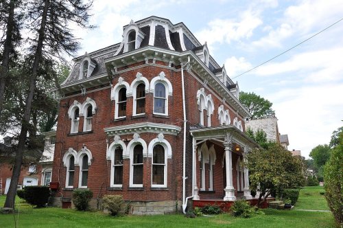
Two places: the Samuel F. Dale House (listed 1975) and the Franklin Historic District (1984).
How old are the homes in Franklin?
52% of Franklin’s homes were built before 1940 (Census estimate, ±5.7 points), against a typical 18% for a Pennsylvania town; the median home was built in 1938.
Founding dates: Wikidata, Wikipedia, the U.S. post office records of Blevins & Helbock (CC0) and the Census. Homes by year built: Census ACS 2020–24. National Register of Historic Places: National Park Service (list of May 22, 2026). Old photos, postcards and papers: Wikimedia Commons, the Library of Congress and other public archives, credited on each item’s page. Maps: U.S. Geological Survey historical topographic maps (via Esri) and Sanborn fire-insurance maps (Library of Congress). History text and census tables: Wikipedia (CC BY-SA 4.0). Places that used to be: USGS Geographic Names Information System (2021).
From Wikimedia Commons (15), the Library of Congress (3), the National Register of Historic Places (2), Wikipedia, Wikidata and Wikipedia for famous people, U.S. Geological Survey historical maps, U.S. Census counts (via Wikipedia), the US Post Offices dataset (Blevins & Helbock), the USGS Geographic Names Information System, Sanborn fire insurance maps (Library of Congress) and old county and town histories (Internet Archive). Archive images are copied here with their credits and licenses, shown on each photo’s page. Refreshed monthly.




 1850
 1864
 1864
 1866
 1880
 1901
 1901
 1902
 1902
 1905
 1905
 1918
 1923
 c. 1930
 c. 1930
 c. 1930
 1930–1945
 c. 1930


