Ephrata dates to 1732, and 24% of its homes were built before 1940
More historic than 97% of U.S. towns · #95 of 1,035 in Pennsylvania. What drives it
6 places in town are on the National Register, among them the Ephrata Cloister, a National Historic Landmark, and two historic districts with 44 buildings between them. Below: 10 old photos and papers, maps from 1906 on, and the census since 1880.
Founding year: Wikipedia. First post office: 1816.The full story ↓
History grade
What drives Ephrata’s History grade
On its age, its old homes and the National Register, Ephrata is more historic than 97% of U.S. towns, #95 of 1,035 in Pennsylvania. All 3 inputs are above most U.S. towns; its age ranks highest and its share of homes from before 1940 lowest.
A+
HistoryA character grade: shown, never part of Ephrata’s overall grade.
Pennsylvania towns list about as much on the Register as the country (a typical Pennsylvania town has 2.1 per 10,000 residents, the U.S. 2.4), so Ephrata’s 41.4 sits above most of its state (85% of Pennsylvania towns have fewer) while its 57 historic buildings outnumber those of 86% of U.S. towns.
NoteThe founding year comes from Wikipedia alone; no second source gives 1732.
How sure. Graded on any two of the three inputs instead, the letter would range from A to A+. The pre-1940 share is a Census survey estimate (±4.7 points).
Founding year: Wikipedia (other dates in Quick answers). Homes: Census ACS 2020–24. National Register: National Park Service, May 2026 list; each listing counted once (boundary changes and added documentation belong to their listing), and a historic district counts its contributing buildings. How TownRatings grades history →
What stands out about Ephrata’s past
Read from the archive, the National Register and the record. The page puts what stands out first.
Ephrata is noteworthy for having been the former seat of the Mystic Order of the Solitary, a semimonastic order of Seventh-Day Dunkers. The community, which contained both men and women, was founded by Johann Conrad Beissel in 1732.
Many of the members were well-educated; Peter Miller, second prior of the monastery, translated the Declaration of Independence into seven languages, at the request of Congress. At the period of its greatest prosperity, the community contained nearly 300 persons.
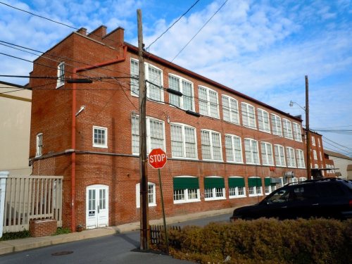
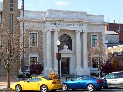
The Ephrata Commercial Historic District, Ephrata Cloister, Eby Shoe Corporation buildings, Connell Mansion, Mentzer Building, and Mountain Springs Hotel are listed on the National Register of Historic Places.
Passages that mention Ephrata, cut from the printed page as they were published.
The German sectarians of Pennsylvania1899 · page 416Read the page →
Read the text
During the regime of Prior Jaebez the following legacies were left to the Community : May I, 1772, Peter Shoemaker left by will two hundred acres of land in trust for Christian people in Ephrata. May i, 1772, an agreement or indenture was made between Peter Shoemaker, of Ephrata, of the one part, and Jacob Senseman, Eudwig Hacker, Jacob Eicher, Jacob Neagley, and Peter Fahnestock, of Ephrata, yeomen, and Barbara Mayer, Ver-
Text read by machine from the scan; it may contain errors.
Souvenir book of the Ephrata cloister1921 · page 62Read the page →
Read the text
The town of Ephrata is nicely laid out, though somewhat irregularly, and lies on the north and west of the Ephrata hills, and by the Lancaster papers is often called the “mountain town,” whilst writers in magazines and the daily press have termed it the “quaint and quiet village.” Suffice it to say that Ephrata has nicely graded streets, fine pavements, elegant homes, good water, excellent schools, plenty of churches and societies, and is ever hospitable to all respectable visitors. In fact, there is that warmth
Text read by machine from the scan; it may contain errors.
History of Lancaster County, Pennsylvania1883Read the page →
Read the text
Tiius we liave briefly outlined tlie pioneer settlement of Old Ephrata, which covers the land, or nearly so, upon wliich the town of Ephrata is situated. This outline gives also tlie religious sentiment |irevailing at that time, and we only wish it were in our power to give a more full and satisfactory detail of the circumstances attending tlie early settlement of the town, the building of the old cloisters or c(jn-
Text read by machine from the scan; it may contain errors.
Souvenir book of the Ephrata cloister1921 · page 40Read the page →
Read the text
He became pastor of the Ephrata persuasion, at the Antietam. He had been at Ephrata, a religious institution in Lancaster County, Pa., and acquired a knowledge of the Ephrata church music, which he afterwards introduced at Snow Hill, and the probability seems to be, that he at once commenced making arrangements to found an institution like the one at Ephrata.
Text read by machine from the scan; it may contain errors.
Scans and text from the Internet Archive. Books published in 1930 or earlier, which are in the public domain.
Timeline
Ephrata, 1701 to 2020
Woven from the archive, old maps, post office records, the National Register and the people born here.
Nothing in the archives for these yearsWeddings on Main Street, storms, parades, school pictures, the old store. If it’s in your family album, it belongs here.
Nothing in the archives for these yearsWeddings on Main Street, storms, parades, school pictures, the old store. If it’s in your family album, it belongs here.
In 1732, according to Wikipedia’s history of the town. Ephrata’s post office opened in 1816, and the census of 1880 counted 392 people here.
How does Ephrata rank for history?
Ephrata is more historic than 97% of U.S. towns, #95 of 1,035 in Pennsylvania. The History grade combines the town’s founding era, the share of homes built before 1940 and its National Register listings. It’s a character grade, so it isn’t part of the overall grade. How it works.
What is on the National Register in Ephrata?
6 listings: 4 buildings and 2 historic districts, the Ephrata Cloister and the Ephrata Commercial Historic District, with 44 contributing buildings. 57 historic buildings in all.
How old are the homes in Ephrata?
24% of Ephrata’s homes were built before 1940 (Census estimate, ±4.7 points), against a typical 18% for a Pennsylvania town; the median home was built in 1971.
Founding dates: Wikidata, Wikipedia, the U.S. post office records of Blevins & Helbock (CC0) and the Census. Homes by year built: Census ACS 2020–24. National Register of Historic Places: National Park Service (list of May 22, 2026). Old photos, postcards and papers: Wikimedia Commons, the Library of Congress and other public archives, credited on each item’s page. Maps: U.S. Geological Survey historical topographic maps (via Esri) and Sanborn fire-insurance maps (Library of Congress). History text and census tables: Wikipedia (CC BY-SA 4.0). Places that used to be: USGS Geographic Names Information System (2021).
From Wikimedia Commons (5), the Library of Congress (5), Wikidata (1), the National Register of Historic Places (6), Wikipedia, Wikidata and Wikipedia for famous people, U.S. Geological Survey historical maps, U.S. Census counts (via Wikipedia), the US Post Offices dataset (Blevins & Helbock), the USGS Geographic Names Information System, Sanborn fire insurance maps (Library of Congress) and old county and town histories (Internet Archive). Archive images are copied here with their credits and licenses, shown on each photo’s page. Refreshed monthly.


 ★ Landmark




 1887
 1887
 1890
 1890
 1890
 1890
 c. 1930


