Doylestown dates to 1745, and 28% of its homes were built before 1940
Among the most historic 1% of U.S. towns · #33 of 1,035 in Pennsylvania. What drives it
7 places in town are on the National Register, among them the Fonthill, Mercer Museum and Moravian Pottery and Tile Works, a National Historic Landmark, and three historic districts with 1,062 buildings between them. Below: 11 old photos and papers, maps from 1885 on, and the census since 1840.
Founding year: Wikidata. First post office: 1801.The full story ↓
History grade
What drives Doylestown’s History grade
On its age, its old homes and the National Register, Doylestown is among the most historic 1% of U.S. towns, #33 of 1,035 in Pennsylvania. All 3 inputs are above most U.S. towns; its National Register listings ranks highest and its share of homes from before 1940 lowest.
A+
HistoryA character grade: shown, never part of Doylestown’s overall grade.
Pennsylvania towns list about as much on the Register as the country (a typical Pennsylvania town has 2.1 per 10,000 residents, the U.S. 2.4), so Doylestown’s 1,282 sits above most of its state (98% of Pennsylvania towns have fewer) while its 1,069 historic buildings outnumber those of 99% of U.S. towns.
NoteThe founding year comes from Wikidata alone; no second source gives 1745.
How sure. Graded on any two of the three inputs instead, the letter would still be A+. The pre-1940 share is a Census survey estimate (±5.9 points).
Founding year: Wikidata (other dates in Quick answers). Homes: Census ACS 2020–24. National Register: National Park Service, May 2026 list; each listing counted once (boundary changes and added documentation belong to their listing), and a historic district counts its contributing buildings. How TownRatings grades history →
What stands out about Doylestown’s past
Read from the archive, the National Register and the record. The page puts what stands out first.
Like most of eastern Pennsylvania, present-day Doylestown was inhabited by the Lenape people prior to European settlement. The Lenape, who called the region Lenapehoking, lived along the waterways of the Delaware Valley for thousands of years before William Penn began colonizing Pennsylvania in 1681. European settlers arrived in the area in the early 18th century, drawn by the fertile land of central Bucks County and the crossroads that would become Doylestown's defining geographic feature.
Passages that mention Doylestown, cut from the printed page as they were published.
The history of Bucks County, Pennsylvania1876 · page 709Read the page →
Read the text
Doylestown has outlet to the great outside world by a branch of the North Pennsylvania railroad, uniting with the main line at Lansdale, which was opened to travel in 1856, and several lines of stages. The first stage through Doylestown was that from Easton to Philadelphia, which John Nicholaus commenced running April 29th, 1792, which made weekly trips, down on Monday and up on Thursday, fare two dollars. Nicholaus was succeeded by his son Samuel, who moved down to Danborough to take charge of the
Text read by machine from the scan; it may contain errors.
The history of Bucks County, Pennsylvania1876 · page 748Read the page →
Read the text
to Quakertown via Newtown and Doylestown, and from New Hope via Doylestown to Lancaster, there and back once a week. These routes appear to have been arranged to facilitate the distribution of Aslier Miner's paper, and the mails were carried for several years by the late John Mcintosh, of Doylestown. In addition io the turnpikes already mentioned in these pages, we have the By berry and Bensalem pike, which was chartered March, 1848, and opened for travel in 1852. The length is five and a quarter miles, and it cost
Text read by machine from the scan; it may contain errors.
Scans and text from the Internet Archive. Books published in 1930 or earlier, which are in the public domain.
Timeline
Doylestown, 1745 to 1985
Woven from the archive, old maps, post office records, the National Register and the people born here.
Nothing in the archives for these yearsWeddings on Main Street, storms, parades, school pictures, the old store. If it’s in your family album, it belongs here.
Fire insurance maps drew every building, what it was made of and what it was used for, so insurers could price the risk of fire. Pick a year, then a sheet.
1885Sheet 1 of 1
Edition
Sheets
BrickWoodStone
Sanborn Map Company, via the Library of Congress. Editions published in 1930 or earlier, which are in the public domain.
Then & now
Stand where they stood
No then-and-now pairs yet. Take a photo from the same spot as an old one and they appear here side by side.
Retake this viewRecruits Wanted for the Ringgold Regiment, 104th Pennsylvania Volunteers, 1861
Find the spot, match the angle, and add your photo. It becomes the first then-and-now pair on Doylestown’s page.
In 1745, according to Wikidata. Doylestown’s post office opened in 1801, and the census of 1840 counted 627 people here.
How does Doylestown rank for history?
Doylestown is among the most historic 1% of U.S. towns, #33 of 1,035 in Pennsylvania. The History grade combines the town’s founding era, the share of homes built before 1940 and its National Register listings. It’s a character grade, so it isn’t part of the overall grade. How it works.
What is on the National Register in Doylestown?
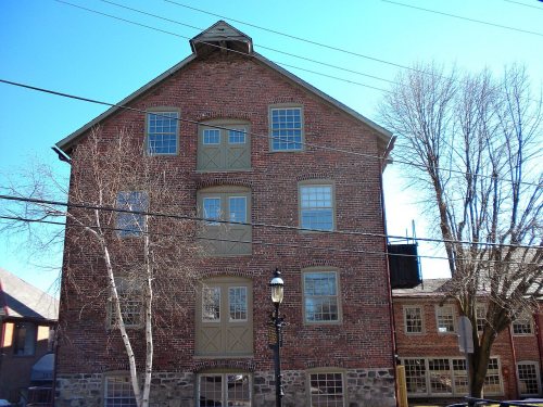
7 listings: 4 buildings, among them the Fountain House (listed 1972, the first), and 3 historic districts, the Fonthill, Mercer Museum and Moravian Pottery and Tile Works, the Shaw Historic District and the Doylestown Historic District, with 1,062 contributing buildings. 1,069 historic buildings in all.
How old are the homes in Doylestown?
28% of Doylestown’s homes were built before 1940 (Census estimate, ±5.9 points), against a typical 18% for a Pennsylvania town; the median home was built in 1963.
Founding dates: Wikidata, Wikipedia, the U.S. post office records of Blevins & Helbock (CC0) and the Census. Homes by year built: Census ACS 2020–24. National Register of Historic Places: National Park Service (list of May 22, 2026). Old photos, postcards and papers: Wikimedia Commons, the Library of Congress and other public archives, credited on each item’s page. Maps: U.S. Geological Survey historical topographic maps (via Esri) and Sanborn fire-insurance maps (Library of Congress). History text and census tables: Wikipedia (CC BY-SA 4.0). Places that used to be: USGS Geographic Names Information System (2021).
From Wikimedia Commons (10), the Library of Congress (1), Wikidata (1), the National Register of Historic Places (7), Wikipedia, Wikidata and Wikipedia for famous people, U.S. Geological Survey historical maps, U.S. Census counts (via Wikipedia), the US Post Offices dataset (Blevins & Helbock), the USGS Geographic Names Information System, Sanborn fire insurance maps (Library of Congress) and old county and town histories (Internet Archive). Archive images are copied here with their credits and licenses, shown on each photo’s page. Refreshed monthly.


 ★ Landmark




 1863
 1867
 1867
 1880
 1891
 1933


