Founding year: Wikipedia. First post office: 1809.The full story ↓
History grade
What drives Darby’s History grade
On its age, its old homes and the National Register, Darby is more historic than 92% of U.S. towns, #152 of 1,035 in Pennsylvania. All 3 inputs are above most U.S. towns; its age ranks highest and its National Register listings lowest.
A
HistoryA character grade: shown, never part of Darby’s overall grade.
Pennsylvania towns list about as much on the Register as the country (a typical Pennsylvania town has 2.1 per 10,000 residents, the U.S. 2.4), so Darby’s 1.9 sits near the middle of its state (57% of Pennsylvania towns have fewer) while its 2 historic buildings outnumber those of 60% of U.S. towns.
How sure. Graded on any two of the three inputs instead, the letter would range from A− to A+. The pre-1940 share is a Census survey estimate (±5.8 points). Two sources give 1682.
Founding year: Wikipedia (other dates in Quick answers). Homes: Census ACS 2020–24. National Register: National Park Service, May 2026 list; each listing counted once (boundary changes and added documentation belong to their listing), and a historic district counts its contributing buildings. How TownRatings grades history →
What stands out about Darby’s past
Read from the archive, the National Register and the record. The page puts what stands out first.
Nothing in the archives for these yearsWeddings on Main Street, storms, parades, school pictures, the old store. If it’s in your family album, it belongs here.
Darby was settled in 1682 by seven Quaker families led by abolitionist and fair trade advocate John Blunston. The name Darby is derived from the English city of Derby (pronounced "Darby"), the county town of Derbyshire (pronounced "Darbyshire"), the origin of many early settlers. Incorporated on May 3, 1853, it had 3,429 residents in 1900, 6,305 in 1910, 10,334 in 1940, and 10,687 at the 2010 census.
Passages that mention Darby, cut from the printed page as they were published.
History of Delaware County, Pennsylvania1884 · page 737Read the page →
Read the text
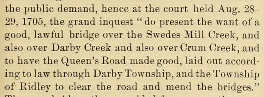
the public demand, hence at the court held Aug. 28- 29, 1705, the grand inquest "do present the want of a good, lawful bridge over the Swedes Mill Creek, and also over Darby Creek and also over Crum Creek, and to have the Queen's Road made good, laid out according to law through Darby Township, and the Township of Ridley to clear the road and mend the bridges."
Text read by machine from the scan; it may contain errors.
History of Delaware county, Pennsylvania, from the discovery of the territory included within its limits to the present time, with a notice of the geology of the county, and catalogues of its minerals, plants, quadrupeds, and birds1862Read the page →
Read the text
The Friends' Meeting-house at Darby is a large and substantial building. Another meeting-house was erected in Upper Darby, after the division of the Society, by those termed Orthodox. The Methodists have one church in Darby and one in Upper Darby, and the Presbyterians two churches in Darby township. There is also a New Jerusalem Church in Upper Darby, the only one of that denomination in the County.
Text read by machine from the scan; it may contain errors.
History of Delaware county, Pennsylvania, from the discovery of the territory included within its limits to the present time, with a notice of the geology of the county, and catalogues of its minerals, plants, quadrupeds, and birds1862 · page 163Read the page →
Read the text
passed "the Hamlet of Bethell." Another road was laid out, " from Edgmont to the Kings High way in Chester, being a sixty foote road;" another "from Newtown, Marple & Springfield to the landing at Amosland," and also one from Darby to Haverford. This last road was laid out "by the Grand Jury and other neighbours ," under an order from the Court "that the township of Darby finde out a convenient High way from thence to the township of Hartford."
Text read by machine from the scan; it may contain errors.
History of Delaware County, Pennsylvania1884 · page 521Read the page →
Read the text
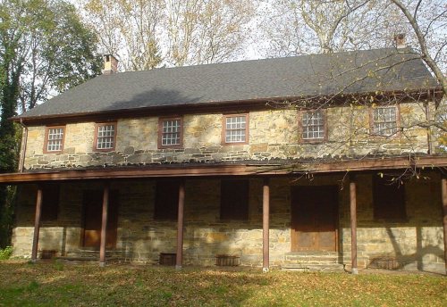
Darby Friends' Meeting-House. — The early Friends who, fleeing from persecution in England, settled in and about Darby, seem to have turned their attention speedily to arranging for religious services, and in the very year of Penn's coming, 1682, tradition states a meeting was held at the present village, in the house of John Blunston, whose hastilyconstructed residence stood near the mill-race, which
Text read by machine from the scan; it may contain errors.
Scans and text from the Internet Archive. Books published in 1930 or earlier, which are in the public domain.
Then & now
Stand where they stood
No then-and-now pairs yet. Take a photo from the same spot as an old one and they appear here side by side.
Retake this view1940 Census Enumeration District Maps - Pennsylvania - Delaware County - Darby - ED 23-61 - ED 23-69, 1880
Find the spot, match the angle, and add your photo. It becomes the first then-and-now pair on Darby’s page.
In 1682, according to Wikipedia’s history of the town. Darby’s post office opened in 1809, and the census of 1860 counted 780 people here.
How does Darby rank for history?
Darby is more historic than 92% of U.S. towns, #152 of 1,035 in Pennsylvania. The History grade combines the town’s founding era, the share of homes built before 1940 and its National Register listings. It’s a character grade, so it isn’t part of the overall grade. How it works.
What is on the National Register in Darby?
One place: the Darby Meeting (listed 1978).
How old are the homes in Darby?
30% of Darby’s homes were built before 1940 (Census estimate, ±5.8 points), against a typical 18% for a Pennsylvania town; the median home was built in 1949.
Founding dates: Wikidata, Wikipedia, the U.S. post office records of Blevins & Helbock (CC0) and the Census. Homes by year built: Census ACS 2020–24. National Register of Historic Places: National Park Service (list of May 22, 2026). Old photos, postcards and papers: Wikimedia Commons, the Library of Congress and other public archives, credited on each item’s page. Maps: U.S. Geological Survey historical topographic maps (via Esri) and Sanborn fire-insurance maps (Library of Congress). History text and census tables: Wikipedia (CC BY-SA 4.0). Places that used to be: USGS Geographic Names Information System (2021).
From Wikimedia Commons (18), the National Register of Historic Places (1), Wikipedia, Wikidata and Wikipedia for famous people, U.S. Geological Survey historical maps, U.S. Census counts (via Wikipedia), the US Post Offices dataset (Blevins & Helbock), the USGS Geographic Names Information System and old county and town histories (Internet Archive). Archive images are copied here with their credits and licenses, shown on each photo’s page. Refreshed monthly.




 1880
 1880
 1880
 1899
 1999
 1999
 1999
 1999
 1999
 1999
 1999
 1999
 1999
 2007