
The story
Read it all →How Claysville came to be
From Wikipedia’s history of Claysville.
The Montgomery House was listed on the National Register of Historic Places in 2002.
Text from Wikipedia, licensed CC BY-SA 4.0.
Each edition grades its towns against each other only.
Claysville dates its founding to 1812 (Wikidata). The census first counted it in 1850.
Read from the archive, the National Register and the record. The page puts what stands out first.
The first neighbors to add old photos shape how Claysville’s history is told.
From Wikipedia’s history of Claysville.
The Montgomery House was listed on the National Register of Historic Places in 2002.
Text from Wikipedia, licensed CC BY-SA 4.0.
Peaked at 1,045 in 1910; 718 people lived here in 2020.
18 censuses, 1850–2020.
U.S. Census Bureau decennial counts, from the census table on Claysville’s Wikipedia page.
Passages that mention Claysville, cut from the printed page as they were published.

' The town of West Alexander, which had been laid out by Robert Humphreys in 1700, was re-laid out (or added to) by Charles Do Uass iu the same year in which Claysville was platted (1817). And De Ilass in this reviving or relaying out of his town changed the name from the original " West Alexander" to " Alexandria."
Text read by machine from the scan; it may contain errors.
The town of Claysville is in Donegal township, and was erected into a borough the second day of April, 1832, and the lots sold on the 8th of May following. Each lot is fifty by two hundred feet deep, with suitable and convenient streets and alleys to each block.
Text read by machine from the scan; it may contain errors.Scans and text from the Internet Archive. Books published in 1930 or earlier, which are in the public domain.
Woven from the archive, old maps, post office records, the National Register and the people born here.
 Born hereWilliam Holmes McGuffey is born here
 Born hereBenjamin Franklin Jones is born here
 Born hereAlexander Kerr Craig is born here
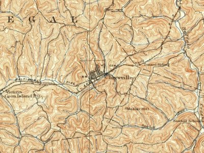 On the mapFirst mapped by the U.S. Geological Survey
 2024US 40 eb-PA 231 nb in Claysville, Aug. 2024
 2024PA 231 nb entering Claysville, Aug. 2024
 2014Caldwell Tavern
 2012Pennsylvania State Route 231
 2012Pennsylvania State Route 231
 2012Pennsylvania State Route 231
 2012First Baptist Church (Claysville, Pennsylvania) (96)
 2012Claysville, Pennsylvania
 2012Claysville, Pennsylvania
 2012Claysville, Pennsylvania
 2012Claysville, Pennsylvania
 2012Claysville, Pennsylvania
 2012Claysville, Pennsylvania
 2012Claysville, Pennsylvania
 2012Claysville, Pennsylvania
 2012Claysville, Pennsylvania
 2012Claysville, Pennsylvania
 2012Claysville, Pennsylvania
 2012Claysville, Pennsylvania
 2012Claysville, Pennsylvania
 2012Claysville, Pennsylvania
 2012Claysville, Pennsylvania
 2012Claysville, Pennsylvania
 2012Claysville, Pennsylvania
 2012Claysville, Pennsylvania
 2012Claysville, Pennsylvania
 2010Montgomery House in
Every edition of the U.S. Geological Survey’s map of Claysville. Tap a year, or press play to watch the town change.

U.S. Geological Survey historical topographic maps (public domain), via Esri’s collection of the scans. The red ring marks the center of Claysville.
Fire insurance maps drew every building, what it was made of and what it was used for, so insurers could price the risk of fire. Pick a year, then a sheet.
 1896Sheet 1 of 2
Sanborn Map Company, via the Library of Congress. Editions published in 1930 or earlier, which are in the public domain.
Writers, athletes, leaders and more, ranked by how widely they’re known.
In 1812, according to Wikidata. Claysville’s post office opened in 1818, and the census of 1850 counted 275 people here.
What the archives can’t tell you, neighbors can.
Founding dates: Wikidata, Wikipedia, the U.S. post office records of Blevins & Helbock (CC0) and the Census. Homes by year built: Census ACS 2020–24. National Register of Historic Places: National Park Service (list of May 22, 2026). Old photos, postcards and papers: Wikimedia Commons, the Library of Congress and other public archives, credited on each item’s page. Maps: U.S. Geological Survey historical topographic maps (via Esri) and Sanborn fire-insurance maps (Library of Congress). History text and census tables: Wikipedia (CC BY-SA 4.0). Places that used to be: USGS Geographic Names Information System (2021). How TownRatings grades history →
From Wikimedia Commons (27), Wikidata (2), Wikipedia, Wikidata and Wikipedia for famous people, U.S. Geological Survey historical maps, U.S. Census counts (via Wikipedia), the US Post Offices dataset (Blevins & Helbock), the USGS Geographic Names Information System, Sanborn fire insurance maps (Library of Congress) and old county and town histories (Internet Archive). Archive images are copied here with their credits and licenses, shown on each photo’s page. Refreshed monthly.


