Chester Heights’ post office opened in 1911, and 4 of its places are on the National Register
More historic than 40% of U.S. towns · #864 of 1,035 in Pennsylvania. What drives it
Most of Chester Heights was built recently: 5% of its homes predate 1940 and the median home dates from 1987. 4 places in town are on the National Register, among them a historic district with 101 buildings. Below: 1 old photo or paper, maps from 1894 on, and the census since 1950.
Founding year: the first Chester Heights post office (Blevins & Helbock, CC0). Wikidata: 1945.The full story ↓
History grade
What drives Chester Heights’ History grade
On its age, its old homes and the National Register, Chester Heights is more historic than 40% of U.S. towns, #864 of 1,035 in Pennsylvania. Its National Register listings hold the grade up; its age pulls it down.
C+
HistoryA character grade: shown, never part of Chester Heights’ overall grade.
Pennsylvania towns list about as much on the Register as the country (a typical Pennsylvania town has 2.1 per 10,000 residents, the U.S. 2.4), so Chester Heights’ 356 sits above most of its state (93% of Pennsylvania towns have fewer) while its 105 historic buildings outnumber those of 90% of U.S. towns.
How sure. Graded on any two of the three inputs instead, the letter would range from D to B+. The pre-1940 share is a Census survey estimate (±3.6 points). The founding year is the first post office, not a stated founding date; Wikidata gives 1945.
Founding year: the first post office (other dates in Quick answers). Homes: Census ACS 2020–24. National Register: National Park Service, May 2026 list; each listing counted once (boundary changes and added documentation belong to their listing), and a historic district counts its contributing buildings. How TownRatings grades history →
What stands out about Chester Heights’ past
Read from the archive, the National Register and the record. The page puts what stands out first.
National Park Service, National Register of Historic Places. Photos from Wikimedia Commons, credited on each place’s page.
On the map
Chester Heights on the map, 1894 to 1994
Every edition of the U.S. Geological Survey’s map of Chester Heights. Tap a year, or press play to watch the town change.
1894Chester sheet · 1:62,500
U.S. Geological Survey historical topographic maps (public domain), via Esri’s collection of the scans. The red ring marks the center of Chester Heights.
The history of Chester Heights predates grants of William Penn, when the Swedes had penetrated some distance inland from the Delaware River and had found the rich soil very conducive to productive farming. To a remarkable extent, the area had continued to be so used until the last decade. In the 18th and 19th centuries, the borough was part of Aston Township, though this northernmost section of Aston did not have a village aspect as such. With the advent of a railroad, which made its first run-through on Christmas Day 1833, a concentration of houses developed. With the reach of the automobile, a settlement of homes sprang up along the oldest road in the borough. That route, now Valleybrook Road, was once known as the "Logtown Road" and was one of the earliest routes from Chester settlement to the interior. It wanders over and along the West Branch of Chester Creek and is noted for its a…
Chester Heights Camp-Meeting Association. — j In 1872 an association of Methodists purchased a farm j in Aston, on the line of the Baltimore Central Railroad, and was incorporated under the title Chester Heights Camp-Meeting Association. The tract contains about one hundred and sixty-two acres, of which about sixty was woodland, which is inclosed with a close fence seven feet high, having gates located at
Text read by machine from the scan; it may contain errors.
History of Delaware County, Pennsylvania1884 · page 302Read the page →
Read the text
flict with the discipline of the Methodist Church, and no excursion where dancing is permitted can be allowed access to the grounds. A post-oflSce, known as Chester Heights, has been established by the United States at this station on the road, and during the continuance of the camp the mail distributed here is large. The association furnishes free railroad tickets to ministers to the Heights and lodging while there.
Text read by machine from the scan; it may contain errors.
Scans and text from the Internet Archive. Books published in 1930 or earlier, which are in the public domain.
Timeline
Chester Heights, 1891 to 1922
Woven from the archive, old maps, post office records, the National Register and the people born here.
Nothing in the archives for these yearsWeddings on Main Street, storms, parades, school pictures, the old store. If it’s in your family album, it belongs here.
The Chester Heights post office opened in 1911, the earliest record of the town by name (U.S. post office records). Wikidata gives 1945.
How does Chester Heights rank for history?
Chester Heights is more historic than 40% of U.S. towns, #864 of 1,035 in Pennsylvania. The History grade combines the town’s founding era, the share of homes built before 1940 and its National Register listings. It’s a character grade, so it isn’t part of the overall grade. How it works.
What is on the National Register in Chester Heights?
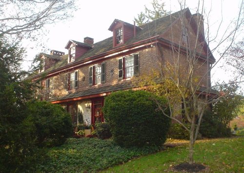
4 listings: 3 buildings, among them the Forge Hill (listed 1973, the first), and 1 historic district, the Chester Heights Camp Meeting Historic District, with 101 contributing buildings. 105 historic buildings in all.
How old are the homes in Chester Heights?
5% of Chester Heights’ homes were built before 1940 (Census estimate, ±3.6 points), against a typical 18% for a Pennsylvania town; the median home was built in 1987.
Founding dates: Wikidata, Wikipedia, the U.S. post office records of Blevins & Helbock (CC0) and the Census. Homes by year built: Census ACS 2020–24. National Register of Historic Places: National Park Service (list of May 22, 2026). Old photos, postcards and papers: Wikimedia Commons, the Library of Congress and other public archives, credited on each item’s page. Maps: U.S. Geological Survey historical topographic maps (via Esri) and Sanborn fire-insurance maps (Library of Congress). History text and census tables: Wikipedia (CC BY-SA 4.0). Places that used to be: USGS Geographic Names Information System (2021).
From Wikimedia Commons (8), the National Register of Historic Places (4), Wikipedia, Wikidata and Wikipedia for famous people, U.S. Geological Survey historical maps, U.S. Census counts (via Wikipedia), the US Post Offices dataset (Blevins & Helbock), the USGS Geographic Names Information System and old county and town histories (Internet Archive). Archive images are copied here with their credits and licenses, shown on each photo’s page. Refreshed monthly.




 2025
 2025
 2025
 2025
 2016
 2014
 2007