Carlisle dates to 1751, and 40% of its homes were built before 1940
Among the most historic 1% of U.S. towns · #20 of 1,035 in Pennsylvania. What drives it
3 places in town are on the National Register, among them the Old West, Dickinson College, a National Historic Landmark, and a historic district with 1,011 buildings. Below: 18 old photos and papers, maps from 1885 on, and the census since 1800.
Founding year: Wikidata. First post office: 1788.The full story ↓
History grade
What drives Carlisle’s History grade
On its age, its old homes and the National Register, Carlisle is among the most historic 1% of U.S. towns, #20 of 1,035 in Pennsylvania. All 3 inputs put Carlisle near the top nationally; its National Register listings ranks highest.
A+
HistoryA character grade: shown, never part of Carlisle’s overall grade.
Pennsylvania towns list about as much on the Register as the country (a typical Pennsylvania town has 2.1 per 10,000 residents, the U.S. 2.4), so Carlisle’s 463 sits above most of its state (94% of Pennsylvania towns have fewer) while its 1,012 historic buildings outnumber those of 99% of U.S. towns.
NoteThe founding year comes from Wikidata alone; no second source gives 1751.
How sure. Graded on any two of the three inputs instead, the letter would still be A+. The pre-1940 share is a Census survey estimate (±4.9 points).
Founding year: Wikidata (other dates in Quick answers). Homes: Census ACS 2020–24. National Register: National Park Service, May 2026 list; each listing counted once (boundary changes and added documentation belong to their listing), and a historic district counts its contributing buildings. How TownRatings grades history →
What stands out about Carlisle’s past
Read from the archive, the National Register and the record. The page puts what stands out first.
National Park Service, National Register of Historic Places. Photos from Wikimedia Commons, credited on each place’s page.
Every building
Carlisle, building by building, 1885–1923
Fire insurance maps drew every building, what it was made of and what it was used for, so insurers could price the risk of fire. Pick a year, then a sheet.
Nothing in the archives for these yearsWeddings on Main Street, storms, parades, school pictures, the old store. If it’s in your family album, it belongs here.
The French-born fur trader James Le Tort may have built a cabin in the area as early as 1720. During the colonial era, Scots-Irish settlers began to settle in the Cumberland Valley beginning in the early 1730s. The settlement of Carlisle, at the intersection of several Indigenous trails, was designated by the Pennsylvania assembly and the Penn family in 1751 as the seat of Cumberland County (named for the county of the same name in England). American engineer John Armstrong Sr., a surveyor for the Penn family, laid the plan for the settlement of Carlisle in 1751. Armstrong Sr. settled there and fathered John Armstrong Jr. in 1758. They named the settlement after its sister town of the same name in Cumberland, England, and even designed its former jailhouse (which now serve as general government offices in the county) to resemble the Carlisle Citadel.
Passages that mention Carlisle, cut from the printed page as they were published.
The centennial memorial of the Presbytery of Carlisle1889 · page 40Read the page →
Read the text
After leaving the Conococheague churches he preached for a time at Nottingham, Maryland, and then at York and Shrewsbury, in Pennsylvania, and, on the union of the Synods, in 1758, was called, April 20, 1759, to Carlisle, where he took charge of the congregation of Upper Pennsboro', or Meeting House Springs. George Duffield had just before this been called to Big Spring and the New Side congregation at Carlisle.
Text read by machine from the scan; it may contain errors.
Early history and growth of Carlisle1905 · page 10Read the page →
Read the text
information we have as to its condition during that period is gleaned from a letter written from Carlisle on May 27, 1753, by John O'Neal to Governor Hamilton, the former having been sent to Carlisle on public business. The letter states: "The garrison here consists only of twelve men. The stockade originally occupied two acres of ground square, with a block-house in each corner : these buildings
Text read by machine from the scan; it may contain errors.
The centennial memorial of the Presbytery of Carlisle1889 · page 267Read the page →
Read the text
Here he commenced his ministry as pastor of these two small churches, one in Carlisle, with two other preaching places, one of which was at the Stone church where he was ordained, and the other was at Dillsburg, six or eight miles southeast of Carlisle, and the other church was in Perry county. His salary was four hundred and fifty dollars. His ministrv was earnest and successful. By reason of his natural eloquence, his sound and evangelical expositions of divine truth, many in Carlisle
Text read by machine from the scan; it may contain errors.
Scans and text from the Internet Archive. Books published in 1930 or earlier, which are in the public domain.
Timeline
Carlisle, 1751 to 1969
Woven from the archive, old maps, post office records, the National Register and the people born here.
AshlandAshland Cemetery Soldiers' LotCumberland Valley Memorial GardensLincoln Cemetery - Memorial ParkOldSaint PatricksSecond Presbyterian ChurchUnion
US Post Offices dataset (Blevins & Helbock, CC0). Places and cemeteries from the USGS Geographic Names Information System (2021).
Help out
Finish Carlisle’s story
Most archives stop around 1920. The photos from after that are in family albums, not libraries.
Decades since 1900 with photos
00s10s20s30s40s50s60s70s80s90s
0 of 10 decades. The empty ones are waiting for someone’s album.
In 1751, according to Wikidata. Carlisle’s post office opened in 1788, and the census of 1800 counted 2,052 people here.
How does Carlisle rank for history?
Carlisle is among the most historic 1% of U.S. towns, #20 of 1,035 in Pennsylvania. The History grade combines the town’s founding era, the share of homes built before 1940 and its National Register listings. It’s a character grade, so it isn’t part of the overall grade. How it works.
What is on the National Register in Carlisle?
Three places: the Old West, Dickinson College (listed 1966), the Hessian Powder Magazine (1974) and the Carlisle Historic District (1979).
How old are the homes in Carlisle?
40% of Carlisle’s homes were built before 1940 (Census estimate, ±4.9 points), against a typical 18% for a Pennsylvania town; the median home was built in 1953.
Founding dates: Wikidata, Wikipedia, the U.S. post office records of Blevins & Helbock (CC0) and the Census. Homes by year built: Census ACS 2020–24. National Register of Historic Places: National Park Service (list of May 22, 2026). Old photos, postcards and papers: Wikimedia Commons, the Library of Congress and other public archives, credited on each item’s page. Maps: U.S. Geological Survey historical topographic maps (via Esri) and Sanborn fire-insurance maps (Library of Congress). History text and census tables: Wikipedia (CC BY-SA 4.0). Places that used to be: USGS Geographic Names Information System (2021).
From Wikimedia Commons (6), the Library of Congress (12), the National Register of Historic Places (3), Wikipedia, Wikidata and Wikipedia for famous people, U.S. Geological Survey historical maps, U.S. Census counts (via Wikipedia), the US Post Offices dataset (Blevins & Helbock), the USGS Geographic Names Information System, Sanborn fire insurance maps (Library of Congress) and old county and town histories (Internet Archive). Archive images are copied here with their credits and licenses, shown on each photo’s page. Refreshed monthly.


 ★ Landmark


 1789
 1848
 1848
 1860
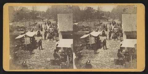 1860
 1860
 1861
 1861
 1865
 1865
 1865
 1865
 1870
 1870
 1871
 1883
 c. 1891
 1891


