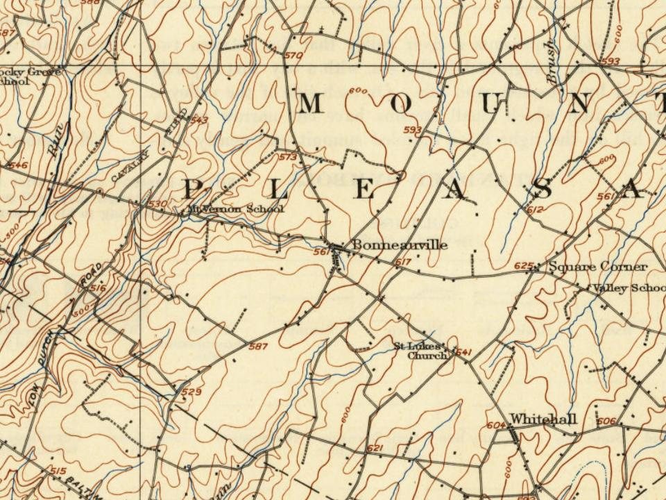
Most of Bonneauville was built recently: 7% of its homes predate 1940 and the median home dates from 1982. Below: maps from 1908 on and the census since 1880.
Founding year: Wikidata. First post office: 1874.The full story ↓
History grade
What drives Bonneauville’s History grade
On its age, its old homes and the National Register, Bonneauville is more historic than 55% of U.S. towns. Its age holds the grade up; its National Register listings pull it down.
B
HistoryA character grade: shown, never part of Bonneauville’s overall grade.
Pennsylvania towns list about as much on the Register as the country (a typical Pennsylvania town has 2.1 per 10,000 residents, the U.S. 2.4), so Bonneauville’s 0.0 sits below most of its state (25% of Pennsylvania towns have fewer) while its 0 listings outnumber those of 23% of U.S. towns.
NoteThe founding year comes from Wikidata alone; no second source gives 1755.
How sure. Graded on any two of the three inputs instead, the letter would range from C− to B+. The pre-1940 share is a Census survey estimate (±4.4 points).
Founding year: Wikidata (other dates in Quick answers). Homes: Census ACS 2020–24. National Register: National Park Service, May 2026 list; each listing counted once (boundary changes and added documentation belong to their listing), and a historic district counts its contributing buildings. How TownRatings grades history →
What stands out about Bonneauville’s past
Read from the archive, the National Register and the record. The page puts what stands out first.
The town's name prior to its 1961 incorporation was "Bonnaughtown" (alternate spelling "Bonnoughtown"), a German name consistent with the area's history of German immigration. The original name appears in journals of officers and soldiers who passed through the town during the Gettysburg campaign of the Civil War.
Passages that mention Bonneauville, cut from the printed page as they were published.
history of adams county pennsylvania.1886 · page 320Read the page →
Read the text
St. Joseph’s Catholic Church of Bonaughtown or Bonneauville was founded in May, 1859, on lands donated by Alexander Shorb. The corner-stone was placed July 31, 1859, and the church was dedicated Febuary 26, 1860. Rev.
Text read by machine from the scan; it may contain errors.
history of adams county pennsylvania.1886 · page 52Read the page →
Read the text
Caledonia Springs. It flows southeast, passes near Fairfield, after which it courses to the south. One of its principal affluents is Muddy Run, which also has its source in the South Mountain eastward of the headwaters of Middle Creek. White Run rises inthe neighborhood of Bonneauville, and after being joined by Plum Run, unites with Rock Creek about a mile south of the Baltimore pike, in Mountjoy Township. Little’s Run has its beginning in the fields and woods east of Bonneauville, and finds its way into Rock Creek near Black’s lower grave-yard. ‘The Bermudian rises in Cumberland County, near the
Text read by machine from the scan; it may contain errors.
Scans and text from the Internet Archive. Books published in 1930 or earlier, which are in the public domain.
Bonneauville had its own post office from 1874 to 1916.
Bonneauville
1874–1916
18701950today
1cemetery inside Bonneauville
Saint Joseph the Worker Catholic Church
US Post Offices dataset (Blevins & Helbock, CC0). Places and cemeteries from the USGS Geographic Names Information System (2021).
Questions about Bonneauville’s history
What year was Bonneauville founded?
In 1755, according to Wikidata. Bonneauville’s post office opened in 1874, and the census of 1880 counted 112 people here.
How does Bonneauville rank for history?
Bonneauville is more historic than 55% of U.S. towns. The History grade combines the town’s founding era, the share of homes built before 1940 and its National Register listings. It’s a character grade, so it isn’t part of the overall grade. How it works.
How old are the homes in Bonneauville?
7% of Bonneauville’s homes were built before 1940 (Census estimate, ±4.4 points), against a typical 18% for a Pennsylvania town; the median home was built in 1982.
Founding dates: Wikidata, Wikipedia, the U.S. post office records of Blevins & Helbock (CC0) and the Census. Homes by year built: Census ACS 2020–24. National Register of Historic Places: National Park Service (list of May 22, 2026). Old photos, postcards and papers: Wikimedia Commons, the Library of Congress and other public archives, credited on each item’s page. Maps: U.S. Geological Survey historical topographic maps (via Esri) and Sanborn fire-insurance maps (Library of Congress). History text and census tables: Wikipedia (CC BY-SA 4.0). Places that used to be: USGS Geographic Names Information System (2021).
From Wikimedia Commons (5), Wikipedia, U.S. Geological Survey historical maps, U.S. Census counts (via Wikipedia), the US Post Offices dataset (Blevins & Helbock), the USGS Geographic Names Information System and old county and town histories (Internet Archive). Archive images are copied here with their credits and licenses, shown on each photo’s page. Refreshed monthly.




 2015
 2015
 2010
 2009
 2009


