Founding year: Wikidata. First post office: 1827.The full story ↓
History grade
What drives Blossburg’s History grade
On its age, its old homes and the National Register, Blossburg is more historic than 77% of U.S. towns. Its share of homes from before 1940 holds the grade up; its National Register listings pull it down.
A−
HistoryA character grade: shown, never part of Blossburg’s overall grade.
Pennsylvania towns list about as much on the Register as the country (a typical Pennsylvania town has 2.1 per 10,000 residents, the U.S. 2.4), so Blossburg’s 0.0 sits below most of its state (25% of Pennsylvania towns have fewer) while its 0 listings outnumber those of 23% of U.S. towns.
How sure. Graded on any two of the three inputs instead, the letter would range from B− to A+. The pre-1940 share is a Census survey estimate (±14.2 points). Two sources give 1802.
Founding year: Wikidata (other dates in Quick answers). Homes: Census ACS 2020–24. National Register: National Park Service, May 2026 list; each listing counted once (boundary changes and added documentation belong to their listing), and a historic district counts its contributing buildings. How TownRatings grades history →
What stands out about Blossburg’s past
Read from the archive, the National Register and the record. The page puts what stands out first.
In 1792, a party of immigrants who were building the Williamson Road from Williamsport, in Lycoming County, to Painted Post in New York, under the leadership of Robert and Benjamin Patterson, discovered coal within the present town limits of Blossburg. When the group reached the Tioga River, they established a supply camp at its banks.
In 1801, Aaron Bloss moved to Tioga County. In 1802, he settled at the area known as "Peter’s Camp". He is considered the first settler of Blossburg. Sometime between 1818 and 1820, Bloss made the first attempt to found a town, changing the name of Peter's Camp to Blossburg. Blossburg was finally recognized and incorporated a borough in August 1871.
Peaked at 2,568 in 1890; 1,533 people lived here in 2020.
15 censuses, 1880–2020.
U.S. Census Bureau decennial counts, from the census table on Blossburg’s Wikipedia page.
From the old history books
What they wrote about Blossburg, 1883–1897
Passages that mention Blossburg, cut from the printed page as they were published.
History of Tioga County, Pennsylvania1897 · page 105Read the page →
Read the text
The Blossburg Coal Company was incorporated by an act of the legislature approved April 11, 1866, for the purpose of opening mines on Johnson's creek, at what is now the village of Arnot, four miles southwest of Blossburg, fmm which place a railroad was constructed to the mines in the year named. In IHH'i and 1883 the Arnot and Pine Creek Railroad Company extended this mad to Hoytville, in Morris township, a distance of twelve miles.
Text read by machine from the scan; it may contain errors.
and in 1859 the railroad from Blossburg to Pall Brook built. In 1863 the repair shops of the Tioga Eailroad Company were removed from Corning to Blossburg, and a new impetus given to the growth and business activity of the place. In 1866 the railroad to Amot was built and the mines opened up there. In 1868 Drake & Taylor erected a saw-mill west of the river, near the site of the old Knapp Hotel.
Text read by machine from the scan; it may contain errors.
History of Tioga County, Pennsylvania1883 · page 90Read the page →
Read the text
did not warrant the expense of developing new coal fields in the township of Bloss. However, a contract was entered into by the Blossburg Coal Company with Messrs. Sherwood and McLean to build a railroad from the Tioga Railroad at Blossburg to the coal fields on Johnson Creek.
Text read by machine from the scan; it may contain errors.
History of Tioga County, Pennsylvania1883 · page 107Read the page →
Read the text
Blossburg is the home of many whose occupations are connected with railroading. Six or seven hundred thousand tons of coal and coke pass through the town from Arnot, Morris Run and Fall Brook annually, and this being the point where the shops, round-houses, etc., of the Tioga Railroad Company are located, the number of railroad men is necessarily large. It includes the following: Conductors— F. A. Higgins, C. L. Shattuck, John Delaney,
Text read by machine from the scan; it may contain errors.
Scans and text from the Internet Archive. Books published in 1930 or earlier, which are in the public domain.
Timeline
Blossburg, 1802 to 1951
Woven from the archive, old maps, post office records, the National Register and the people born here.
Nothing in the archives for these yearsWeddings on Main Street, storms, parades, school pictures, the old store. If it’s in your family album, it belongs here.
Every edition of the U.S. Geological Survey’s map of Blossburg. Tap a year, or press play to watch the town change.
1925Blossburg sheet · 1:62,500
U.S. Geological Survey historical topographic maps (public domain), via Esri’s collection of the scans. The red ring marks the center of Blossburg.
Every building
Blossburg, building by building, 1885–1911
Fire insurance maps drew every building, what it was made of and what it was used for, so insurers could price the risk of fire. Pick a year, then a sheet.
In 1802, according to Wikidata. Blossburg’s post office opened in 1827, and the census of 1880 counted 2,146 people here.
How does Blossburg rank for history?
Blossburg is more historic than 77% of U.S. towns. The History grade combines the town’s founding era, the share of homes built before 1940 and its National Register listings. It’s a character grade, so it isn’t part of the overall grade. How it works.
How old are the homes in Blossburg?
55% of Blossburg’s homes were built before 1940 (Census estimate, ±14.2 points), against a typical 18% for a Pennsylvania town; the median home was built in 1938.
Founding dates: Wikidata, Wikipedia, the U.S. post office records of Blevins & Helbock (CC0) and the Census. Homes by year built: Census ACS 2020–24. National Register of Historic Places: National Park Service (list of May 22, 2026). Old photos, postcards and papers: Wikimedia Commons, the Library of Congress and other public archives, credited on each item’s page. Maps: U.S. Geological Survey historical topographic maps (via Esri) and Sanborn fire-insurance maps (Library of Congress). History text and census tables: Wikipedia (CC BY-SA 4.0). Places that used to be: USGS Geographic Names Information System (2021).
From Wikimedia Commons (18), Wikipedia, Wikidata and Wikipedia for famous people, U.S. Geological Survey historical maps, U.S. Census counts (via Wikipedia), the US Post Offices dataset (Blevins & Helbock), the USGS Geographic Names Information System, Sanborn fire insurance maps (Library of Congress) and old county and town histories (Internet Archive). Archive images are copied here with their credits and licenses, shown on each photo’s page. Refreshed monthly.


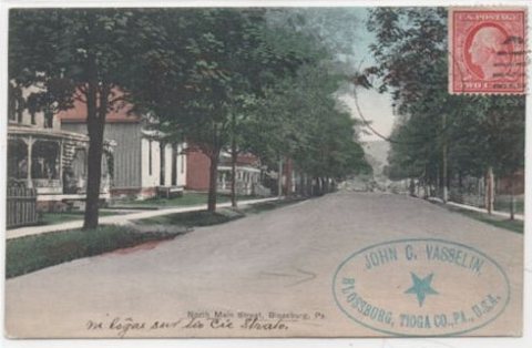


 2013
 2013
 2013
 2013
 2013
 2013
 2013
 2013
 2013
 2013
 2013
 2013
 2013
 2013
 2013
 2008


