Blairsville dates to 1818, and 33% of its homes were built before 1940
More historic than 91% of U.S. towns · #174 of 1,035 in Pennsylvania. What drives it
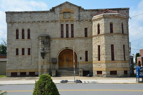
Its Register listings are the St. Peter's Episcopal Church and Rectory and the Blairsville Armory. Below: 5 old photos and papers, maps from 1887 on, and the census since 1830.
Founding year: Wikidata; Wikipedia’s history section gives the same year. First post office: 1821.The full story ↓
History grade
What drives Blairsville’s History grade
On its age, its old homes and the National Register, Blairsville is more historic than 91% of U.S. towns, #174 of 1,035 in Pennsylvania. All 3 inputs are above most U.S. towns; its share of homes from before 1940 ranks highest and its National Register listings lowest.
A
HistoryA character grade: shown, never part of Blairsville’s overall grade.
Pennsylvania towns list about as much on the Register as the country (a typical Pennsylvania town has 2.1 per 10,000 residents, the U.S. 2.4), so Blairsville’s 9.3 sits above most of its state (76% of Pennsylvania towns have fewer) while its 3 historic buildings outnumber those of 65% of U.S. towns.
How sure. Graded on any two of the three inputs instead, the letter would range from A− to A. The pre-1940 share is a Census survey estimate (±8.2 points). Two sources give 1818.
Founding year: Wikidata (other dates in Quick answers). Homes: Census ACS 2020–24. National Register: National Park Service, May 2026 list; each listing counted once (boundary changes and added documentation belong to their listing), and a historic district counts its contributing buildings. How TownRatings grades history →
What stands out about Blairsville’s past
Read from the archive, the National Register and the record. The page puts what stands out first.
Fire insurance maps drew every building, what it was made of and what it was used for, so insurers could price the risk of fire. Pick a year, then a sheet.
Blairsville was settled in 1818 and incorporated in 1825. In the past, railway shops, foundries, machine shops, enameling plants, and manufactories of plate glass and lumber employed the residents. It was the seat of Blairsville College, a Presbyterian institution opened in 1851. In 1858 the area became heavily involved in the Underground Railroad with local families. Some of these families were the Mitchells and Van Leer Family. In a letter to Theodore Parker, a local geologist Peter Lesley stated there were over 3000 men helping the railroad in the area.
The Blairsville Armory and St. Peter's Episcopal Church and Rectory are listed on the National Register of Historic Places.
and milling. After reaching manhood he engaged in various occupations. Moving to Dilltown in 1840 he followed farm work there, and subsequently located at Blairsville, where the latter part of his life was spent and where he died March 3, 1867, aged fifty-nine years, eight months, fourteen days. He was buried in the Lutheran cemetery at Blairsville. IMr.
Text read by machine from the scan; it may contain errors.
his reliability to the Pennsylvania Railroad Company in this manner, he was made conductor of a freight train from Blairsville to Allegheny and Conemaugh, and continued as .a conductor on this road for forty-one years, three mouths, ten days, retiring in 1911. He was known among railroad men as the "lively conductor," and was often called
Text read by machine from the scan; it may contain errors.
Scans and text from the Internet Archive. Books published in 1930 or earlier, which are in the public domain.
Timeline
Blairsville, 1818 to 1978
Woven from the archive, old maps, post office records, the National Register and the people born here.
Nothing in the archives for these yearsWeddings on Main Street, storms, parades, school pictures, the old store. If it’s in your family album, it belongs here.
In 1818, according to Wikidata and Wikipedia’s history of the town. Blairsville’s post office opened in 1821, and the census of 1830 counted 957 people here.
How does Blairsville rank for history?
Blairsville is more historic than 91% of U.S. towns, #174 of 1,035 in Pennsylvania. The History grade combines the town’s founding era, the share of homes built before 1940 and its National Register listings. It’s a character grade, so it isn’t part of the overall grade. How it works.
What is on the National Register in Blairsville?
Two places: the St. Peter's Episcopal Church and Rectory (listed 1988) and the Blairsville Armory (1989).
How old are the homes in Blairsville?
33% of Blairsville’s homes were built before 1940 (Census estimate, ±8.2 points), against a typical 18% for a Pennsylvania town; the median home was built in 1954.
Founding dates: Wikidata, Wikipedia, the U.S. post office records of Blevins & Helbock (CC0) and the Census. Homes by year built: Census ACS 2020–24. National Register of Historic Places: National Park Service (list of May 22, 2026). Old photos, postcards and papers: Wikimedia Commons, the Library of Congress and other public archives, credited on each item’s page. Maps: U.S. Geological Survey historical topographic maps (via Esri) and Sanborn fire-insurance maps (Library of Congress). History text and census tables: Wikipedia (CC BY-SA 4.0). Places that used to be: USGS Geographic Names Information System (2021).
From Wikimedia Commons (11), the Library of Congress (7), the National Register of Historic Places (2), Wikipedia, Wikidata and Wikipedia for famous people, U.S. Geological Survey historical maps, U.S. Census counts (via Wikipedia), the US Post Offices dataset (Blevins & Helbock), the USGS Geographic Names Information System, Sanborn fire insurance maps (Library of Congress) and old county and town histories (Internet Archive). Archive images are copied here with their credits and licenses, shown on each photo’s page. Refreshed monthly.


 1908
 1923
 2019
 2019
 2019
 2019
 2019
 2019
 2018
 2018
 2016
 2014
 2013
 2013
 2010