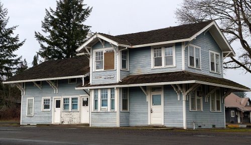
165 years in pictures
The archive holds 6 old photos and papers going back to 1874 and 3 maps from 1942 on.
1 place on the National Register of Historic Places.
- 1861Grand Ronde is settled
Each edition grades its towns against each other only.

Grand Ronde’s weakest subject grade is a D− for incomes. 25% of residents live below the poverty line in Grand Ronde, above both the Oregon town median (11%) and the median of U.S. towns (9.6%). On incomes, just 9 of Oregon’s 228 towns do worse. Grand Ronde's public schools trail 87% of Oregon towns on state tests and graduation. Grand Ronde Rail Depot is on the National Register of Historic Places. Grand Ronde has fewer than 2,500 residents, so it gets subject grades but no overall grade.
Each subject compared with towns across the country (schools within Oregon), ordered by how far Grand Ronde is from typical.
How TownRatings grades towns →
Where Grand Ronde beats most towns, and one thing worth knowing.
Grand Ronde Rail DepotThe archive holds 6 old photos and papers going back to 1874 and 3 maps from 1942 on.
1 place on the National Register of Historic Places.
1,661 counted in 2010 and 2,010 in 2020.
U.S. Census 2010 & 2020 counts
Ordered by what stands out in Grand Ronde.
Among 143 Oregon towns, just 8 have a lower median household income than Grand Ronde. This Oregon town had 1,822 jobs in 2023, up 246 from 2013. The top destinations are McMinnville (8%), Salem (8%) and Portland (6%). For half of commuters, work is under 23 miles away.
| Grand Ronde | Oregon towns | U.S. towns | |
|---|---|---|---|
| Median household income | $53,000 | $81,000 | $80,000 |
| Average trip to work | 25 minutes | 23 minutes | 25 minutes |
Census LEHD 2023 · ACS
18% of adults report frequent physical distress in Grand Ronde. Only 5 of the 143 Oregon towns we compare have a higher share of adults who smoke cigarettes than Grand Ronde.
| Grand Ronde | Oregon towns | U.S. towns | |
|---|---|---|---|
| Frequent physical distress (CDC PLACES) | 18% | 15% | 14% |
| Diabetes (CDC PLACES) | 15% | 11% | 12% |
| Smoke cigarettes (CDC PLACES) | 18% | 13% | 14% |
| Binge drink (CDC PLACES) | 14% | 15% | 16% |
| What stands out | Grand Ronde | OR |
|---|---|---|
| More smokers | 17.9% | 12% |
| More adults with COPD | 9.7% | 6.8% |
| More older adults who have lost all their teeth | 17.6% | 12.5% |
CDC PLACES 2025 · modeled estimates for adults · CMS · HRSA
On expected storm and flood damage, Grand Ronde sits above 86% of U.S. communities. Households in the town have drawn federal disaster aid once, in 2007. Expected losses in Grand Ronde break down as 57% from inland flooding and 37% from earthquakes.
FEMA National Risk Index · OpenFEMA
Summer afternoons peak near 80° in July, and January nights bottom out around 36°; snowfall runs to about 2 inches a winter. The seasons in Grand Ronde: mild winters, pleasant summers, with plenty of rain.
NOAA U.S. Climate Normals, 1991–2020
The typical Grand Ronde home is worth about $458,000, up 1.6% in a year, 7% below the Oregon typical home. Grand Ronde’s typical rent stands at $775 a month.
| Grand Ronde | Oregon towns | U.S. towns | |
|---|---|---|---|
| Households that own their home | 43% | 65% | 73% |
| Median rent | $775 a month | $1,414 a month | $1,185 a month |
Census ACS, 2020–24 · Zillow Home Value Index · Redfin Data Center
In 1 park or preserve, walkers have 20 miles of trail. Among 141 Oregon towns, just 8 have a lower share of conserved land than Grand Ronde. Parks and preserves here: one, of 27 acres.
| Grand Ronde | Oregon towns | U.S. towns | |
|---|---|---|---|
| Miles of trail per square mile | 1.0 miles per square mile | 0.8 | 0.4 |
| Conserved land | 0.5% | 4.4% | 4.3% |
| Biggest places to walk | Trails | Acres |
|---|---|---|
| 1. H.B. Van Duzer Forest State Scenic Corridor | 0.1 mi | 27 |
Trails & parks © OpenStreetMap contributors · Conserved land: USGS PAD-US
Grand Ronde is unincorporated, so Polk County and regional agencies provide most services.
EPA SDWIS (Oct 9, 2026) · HIFLD + EIA-861 2025 · Census 2020 ZCTAs · NCES 2024–25 · registration: vote.gov, updated Oct 2, 2026.
Where Grand Ronde’s working residents go each day. Line width shows the share.
Census LEHD 2023
None within 15 miles of Grand Ronde; the nearest are
About 2 of every 100 Grand Ronde residents are enrolled in college, against 6 across Oregon.
Census-designated place in Oregon, United States
Grand Ronde is a census-designated place (CDP) and unincorporated community in Polk and Yamhill counties, Oregon, United States. Historically noted as a village in Polk County, the sphere of influence and community is in both Polk and Yamhill counties. The name of the community is a variation of the French Grande Ronde or "Grand Round" which could be about the large round-up of Native American peoples in the area who were settled on what was known as the Grand Ronde Indian Reservation, or possibly referencing the shape of the valley in which the community is located. As of the 2020 census, Grand Ronde had a population of 2,010. It is part of the Salem Metropolitan Statistical Area.
From Wikipedia, licensed CC BY-SA 4.0 · facts via Wikidata (CC0)
One town shares a border with Grand Ronde.
| Town | OR rank | Overall | Cost | Safety | Schools | Health |
|---|---|---|---|---|---|---|
| Grand Ronde | — | — | B | — | D | C− |
| Fort Hill | — | — | — | — | — | — |
Grand Ronde has fewer than 2,500 residents, so it gets subject grades but no overall grade. Grand Ronde reports no FBI crime data of its own. Fort Hill isn’t graded (fewer than 1,000 residents, or not enough data). Compare Grand Ronde with a neighbor →
Short answers, built from the data on this page.
Cost of living, which also weighs rents, property taxes and how many households pay 30% or more of their income for housing, grades B.
Ask a question, answer one, post a photo or an event. Free, and the parts only a neighbor would know are the parts worth reading.