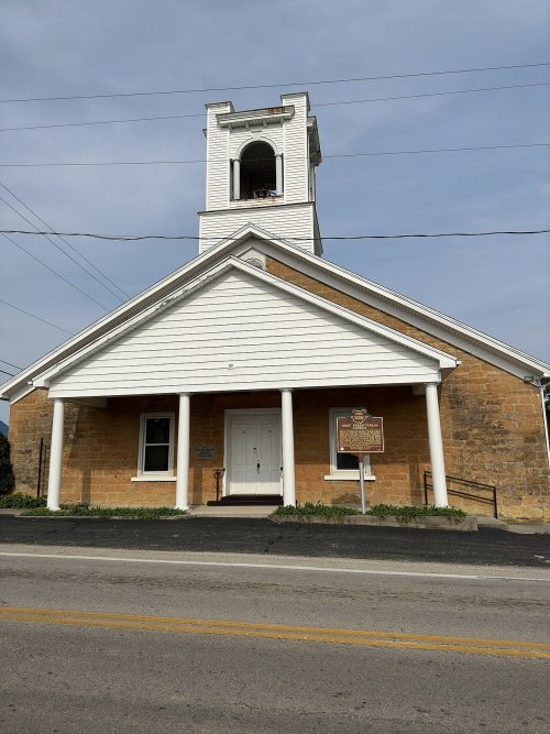
West Union dates to 1803, and 3 of its places are on the National Register
More historic than 69% of U.S. towns · #433 of 993 in Ohio. What drives it
Most of West Union was built recently: 7% of its homes predate 1940 and the median home dates from 1976. Its Register listings are the West Union Presbyterian Church, the Cockerill House and the Tet Woods Building. Below: 1 old photo or paper, maps from 1904 on, and the census since 1810.
Founding year: Wikidata; Wikipedia’s history section gives the same year. First post office: 1805.The full story ↓
History grade
What drives West Union’s History grade
On its age, its old homes and the National Register, West Union is more historic than 69% of U.S. towns, #433 of 993 in Ohio. Its age holds the grade up; its share of homes from before 1940 pulls it down.
B+
HistoryA character grade: shown, never part of West Union’s overall grade.
Ohio towns list about as much on the Register as the country (a typical Ohio town has 2.9 per 10,000 residents, the U.S. 2.4), so West Union’s 10.3 sits above most of its state (75% of Ohio towns have fewer) while its 3 listings outnumber those of 65% of U.S. towns.
How sure. Graded on any two of the three inputs instead, the letter would range from B to A−. The pre-1940 share is a Census survey estimate (±5.0 points). Two sources give 1803.
Founding year: Wikidata (other dates in Quick answers). Homes: Census ACS 2020–24. National Register: National Park Service, May 2026 list; each listing counted once (boundary changes and added documentation belong to their listing), and a historic district counts its contributing buildings. How TownRatings grades history →
What stands out about West Union’s past
Read from the archive, the National Register and the record. The page puts what stands out first.
Fire insurance maps drew every building, what it was made of and what it was used for, so insurers could price the risk of fire. Pick a year, then a sheet.
Passages that mention West Union, cut from the printed page as they were published.
A history of Adams County, Ohio, from its earliest settlement to the present time, including character sketches of the prominent persons identified with the first century of the country's growth ..1900 · page 137Read the page →
Read the text
The Wilson Children's Home is located about one-half mile east of the court house, on the corporation line of the town of West Union, on the south side of the Cedar Mills turnpike, at its junction with the West Union and Locust Grove turnpike. The site is a most pleasing one, affording a fine view of the town of West Union, and of the surrounding country. Thesanitary conditions arc unexcelled, the drainage being perfect, and abundance of pure water easily accessible. The building constructed of brick and native limestone is of modern archi-
Text read by machine from the scan; it may contain errors.
A history of Adams County, Ohio, from its earliest settlement to the present time, including character sketches of the prominent persons identified with the first century of the country's growth ..1900 · page 231Read the page →
Read the text
Henry Soott, West Union, Ohio, was bom March 6, 1838, in Green Township, Adams County. He lived in Jeflferson Township from 1840 till 1872, at which latter date he located in West Union. His education was acquired in the common schools of Jefferson Township, at the old academy at North Liberty, and in the West Union Hisrh School. He taught in Green and Jefferson district schools for about ten years, and was a Digitized by
Text read by machine from the scan; it may contain errors.
Scans and text from the Internet Archive. Books published in 1930 or earlier, which are in the public domain.
Timeline
West Union, 1803 to 1978
Woven from the archive, old maps, post office records, the National Register and the people born here.
West Union’s post office has been open since 1805.
3cemeteries and burying grounds inside West Union
Independent Order of OddfellowsLovejoyPumpkin Ridge
US Post Offices dataset (Blevins & Helbock, CC0). Places and cemeteries from the USGS Geographic Names Information System (2021).
Questions about West Union’s history
What year was West Union founded?
In 1803, according to Wikidata and Wikipedia’s history of the town. West Union’s post office opened in 1805, and the census of 1810 counted 229 people here.
How does West Union rank for history?
West Union is more historic than 69% of U.S. towns, #433 of 993 in Ohio. The History grade combines the town’s founding era, the share of homes built before 1940 and its National Register listings. It’s a character grade, so it isn’t part of the overall grade. How it works.
What is on the National Register in West Union?
Three places: the West Union Presbyterian Church (listed 1976), the Cockerill House (1978) and the Tet Woods Building (1982).
How old are the homes in West Union?
7% of West Union’s homes were built before 1940 (Census estimate, ±5.0 points), against a typical 15% for an Ohio town; the median home was built in 1976.
Founding dates: Wikidata, Wikipedia, the U.S. post office records of Blevins & Helbock (CC0) and the Census. Homes by year built: Census ACS 2020–24. National Register of Historic Places: National Park Service (list of May 22, 2026). Old photos, postcards and papers: Wikimedia Commons, the Library of Congress and other public archives, credited on each item’s page. Maps: U.S. Geological Survey historical topographic maps (via Esri) and Sanborn fire-insurance maps (Library of Congress). History text and census tables: Wikipedia (CC BY-SA 4.0). Places that used to be: USGS Geographic Names Information System (2021).
From Wikimedia Commons (12), Wikidata (3), the National Register of Historic Places (3), Wikipedia, Wikidata and Wikipedia for famous people, U.S. Geological Survey historical maps, U.S. Census counts (via Wikipedia), the US Post Offices dataset (Blevins & Helbock), the USGS Geographic Names Information System, Sanborn fire insurance maps (Library of Congress) and old county and town histories (Internet Archive). Archive images are copied here with their credits and licenses, shown on each photo’s page. Refreshed monthly.



 Date?
 2015
 2013
 2013
 2013
 2013
 2012
 2012
 2012
 2010
 2007
 2004