The West Manchester post office opened in 1855, the earliest record of the town by name. Two smaller post offices, Hagerstown (1832) and Oderkirk (1888), opened inside today’s town and later closed.
First census: 229 in 18802020 census: 415171 years
Founding year: the first West Manchester post office (Blevins & Helbock, CC0).
What stands out about West Manchester’s past
Read from the archive, the National Register and the record. The page puts what stands out first.
Wikipedia doesn’t have a history of West Manchester yet. The photos, dates and memories neighbors add here are how it gets written.
West Manchester is a village in Preble County, Ohio, United States. The population was 415 at the 2020 census. It is part of the Dayton Metropolitan Statistical Area.
Its first post office opened in 1855. Between the 2010 and 2020 censuses its population fell from 474 to 415 (-12%).
Intro from Wikipedia. Population: U.S. Census Bureau.
Places that used to be
Lost post offices
West Manchester’s post office has been open since 1855. Two other post offices opened and closed inside today’s town.
Hagerstown
1832–1855
West Manchester
1855–today
Oderkirk
1888–1889
18301930today
US Post Offices dataset (Blevins & Helbock, CC0). Places and cemeteries from the USGS Geographic Names Information System (2021).
From the old history books
What they wrote about West Manchester, 1881–1915
Passages that mention West Manchester, cut from the printed page as they were published.
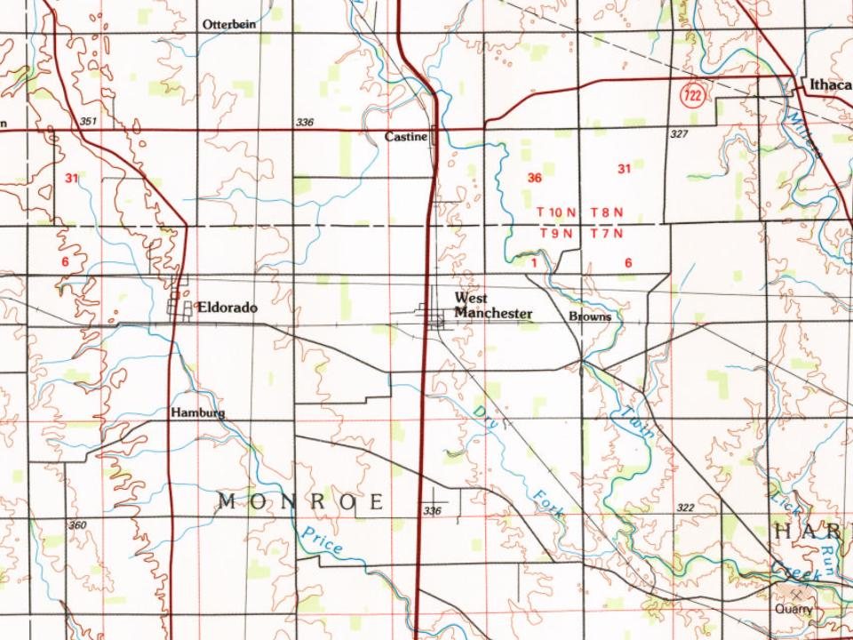
Brown’s Station, on the Dayton & Western railroad, is situated about a mile and a half east of West Manchester, near a water station of the railroad. Some half dozen houses are clustered about the station, but all the business of the hamlet is transacted at West Manchester.
Text read by machine from the scan; it may contain errors.
MANCHESTER, or West Manchester, as it is more properly called, is a thriving village of about one hundred and fifty inhabitants, in the northeastern part of the township, in sections two and eleven. It has never been incorporated, although some attempt has been made in that direction, and the probabilities are that it will soon be a regularly incorporated town. Its growth is rapid, and the business
Text read by machine from the scan; it may contain errors.
There are several small towns within the limits of the township; of these, Eldorado is the only one that is incorporated. The others are West Manchester, Hamburgh and Brown's station. Hagerstown is a place long since fallen into oblivion. Brown's station is a mere railroad station. Hamburgh was formerly a place of some local importance, but it is rapidly becoming an unrecognizable place. Eldorado and West Manchester are the
Text read by machine from the scan; it may contain errors.
In addition to the above, other towns were laid out in the county and plats recorded, but they are now only farm lands. The following names suggest themselves: Hagerstown, northeast of West Manchester; Orangeburg and Belfast, on the National road, west of Gettysburg; Claysburg, southeast of Fair Haven ; Georgetown, north of Sonora ; Mercersburg, on the county line east of Greenbush, and Good Intent, on the Richmond Pike. Crawfordsville still has about a dozen houses and practically adjoins New Hope, while Brinley Station, Brown’s Station and New Hope Station have in the past contributed
Text read by machine from the scan; it may contain errors.
Scans and text from the Internet Archive. Books published in 1930 or earlier, which are in the public domain.
Timeline
West Manchester, 1832 to 1960
Woven from the archive, old maps, post office records, the National Register and the people born here.
Every edition of the U.S. Geological Survey’s map of West Manchester. Tap a year, or press play to watch the town change.
1960New Madison sheet · 1:24,000
U.S. Geological Survey historical topographic maps (public domain), via Esri’s collection of the scans. The red ring marks the center of West Manchester.
Every building
West Manchester, building by building, 1895–1911
Fire insurance maps drew every building, what it was made of and what it was used for, so insurers could price the risk of fire. Pick a year, then a sheet.
1895Sheet 1 of 1
Edition
Sheets
BrickWoodStone
Sanborn Map Company, via the Library of Congress. Editions published in 1930 or earlier, which are in the public domain.
People over time
West Manchester, census by census
Between 229 and 474 people in every census since 1880.
14 censuses, 1880–2020.
U.S. Census Bureau decennial counts, from the census table on West Manchester’s Wikipedia page.
Famous people
Famous people close to West Manchester
Nobody well known was born in West Manchester itself, so here are the best known from just nearby.
Founding dates: Wikidata, Wikipedia, the U.S. post office records of Blevins & Helbock (CC0) and the Census. Homes by year built: Census ACS 2020–24. National Register of Historic Places: National Park Service (list of May 22, 2026). Old photos, postcards and papers: Wikimedia Commons, the Library of Congress and other public archives, credited on each item’s page. Maps: U.S. Geological Survey historical topographic maps (via Esri) and Sanborn fire-insurance maps (Library of Congress). History text and census tables: Wikipedia (CC BY-SA 4.0). Places that used to be: USGS Geographic Names Information System (2021). How TownRatings grades history →
From Wikimedia Commons (4), U.S. Geological Survey historical maps, U.S. Census counts (via Wikipedia), the US Post Offices dataset (Blevins & Helbock), the USGS Geographic Names Information System, Sanborn fire insurance maps (Library of Congress) and old county and town histories (Internet Archive). Archive images are copied here with their credits and licenses, shown on each photo’s page. Refreshed monthly.


 2016
 2016
 2015
 2004