Founding year: the first West Lafayette post office (Blevins & Helbock, CC0). Wikidata: 2016.The full story ↓
History grade
What drives West Lafayette’s History grade
On its age, its old homes and the National Register, West Lafayette is more historic than 67% of U.S. towns. Its share of homes from before 1940 holds the grade up; its National Register listings pull it down.
B+
HistoryA character grade: shown, never part of West Lafayette’s overall grade.
Ohio towns list about as much on the Register as the country (a typical Ohio town has 2.9 per 10,000 residents, the U.S. 2.4), so West Lafayette’s 0.0 sits below most of its state (23% of Ohio towns have fewer) while its 0 listings outnumber those of 23% of U.S. towns.
How sure. Graded on any two of the three inputs instead, the letter would range from C+ to A. The pre-1940 share is a Census survey estimate (±7.5 points). The founding year is the first post office, not a stated founding date; Wikidata gives 2016.
Founding year: the first post office (other dates in Quick answers). Homes: Census ACS 2020–24. National Register: National Park Service, May 2026 list; each listing counted once (boundary changes and added documentation belong to their listing), and a historic district counts its contributing buildings. How TownRatings grades history →
What stands out about West Lafayette’s past
Read from the archive, the National Register and the record. The page puts what stands out first.
West Lafayette was laid out in 1850 by Robert Shaw and William Wheeler. In 1855, the Steubenville and Indiana Railroad was built through the new town. The line became known as the Panhandle Route and was operated in the Pennsylvania Railroad system and currently by the Columbus and Ohio River Railroad (Ohio Central Railroad System). Tragedy struck this track on September 11, 1950, when the crack passenger train "Spirit of St. Louis" hit another train carrying 600 men of the 109th Field Artillery Battalion of the Pennsylvania National Guard. 33 men were killed as a result of the accident. A memorial was placed near the site of the accident in 1990. A 105mm howitzer is at the memorial also, commemorating the manufacture of 105mm shells at Moore Enamelling across the tracks during WWII.
which lot he then owned. In 1836, he sold his lands and removed his store to the Ketchum farm, and from there to Wild Turkey Lock, and in 1850, to the town of West Lafayette, where he died and was succeeded by Abbot & Andreg. Thornton Fleming erected a dwelling and storeroom in 1853, and remained in business there until his death. Samuel Adair sold goods there
Text read by machine from the scan; it may contain errors.
Centennial history of Coshocton County, Ohio1909Read the page →
Read the text
valley extends northw'ard' and along Wills Creek, skirting the southern border of the county, while a strip of such land connects the valley of Wills Creek and the Tuscarawas valley — probably a former channel of the Tuscarawas. It is west of the town of West Lafayette, paralleling the present valley of the Tuscarawas, from which it is separated by a broken range of hills. It extends southward, merging into the
Text read by machine from the scan; it may contain errors.
of the river. It is separated from these bottom lands generally by a bluff rising thirty or fortyfeet. About a half mile north of the village of West Lafayette is a remarkable hill, isolated from all others. The plains stretch away to the south and a narrow valley separates it from the river on the north. Towards the east it rises abruptly to a considerable height, but on the oppo-
Text read by machine from the scan; it may contain errors.
Centennial history of Coshocton County, Ohio1909 · page 363Read the page →
Read the text
he followed foanine years during the winter months, devoting the months of summer to his farming interests. In 1873 he purchased one hundred acres of land, which is now a part of his present fai"m of one hundred and fifty acres adjoining the cori>OTation limits of tlie town of West Lafayette on the north. This constitutes h'ls residence propea-ty and in addition to this 1 >lace he also owns a farm' of two hundred and six acres in Wilson and I>afayette townships and has recently .sold two other farms which he owned.
Text read by machine from the scan; it may contain errors.
Scans and text from the Internet Archive. Books published in 1930 or earlier, which are in the public domain.
By decade
West Lafayette, decade by decade
One decade in the archive so far: the 1900s. Scroll each row; tap a photo for its story.
Nothing in the archives for these yearsWeddings on Main Street, storms, parades, school pictures, the old store. If it’s in your family album, it belongs here.
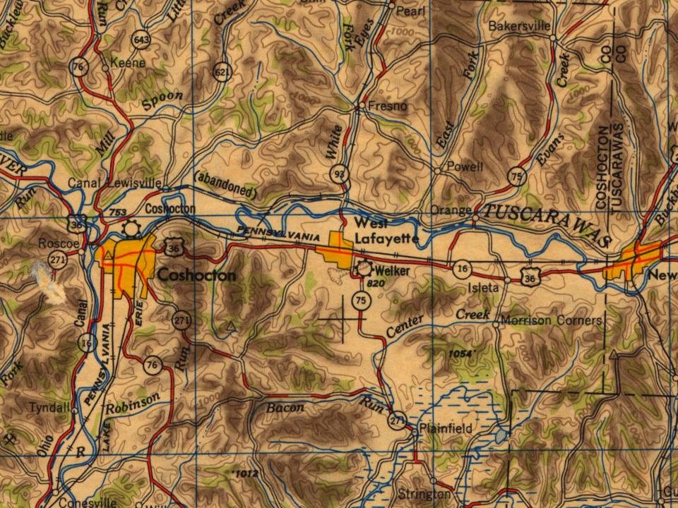
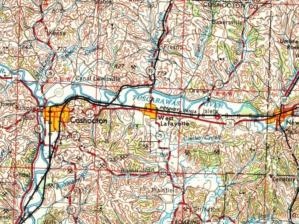
Every edition of the U.S. Geological Survey’s map of West Lafayette. Tap a year, or press play to watch the town change.
1951Canton sheet · 1:250,000
U.S. Geological Survey historical topographic maps (public domain), via Esri’s collection of the scans. The red ring marks the center of West Lafayette.
Then & now
Stand where they stood
No then-and-now pairs yet. Take a photo from the same spot as an old one and they appear here side by side.
Retake this viewM. E. Church, West Lafayette, O, 1903
Find the spot, match the angle, and add your photo. It becomes the first then-and-now pair on West Lafayette’s page.
West Lafayette’s post office has been open since 1840.
Hamlets and corners on the map
Fairview ManorVillage Court
1cemetery inside West Lafayette
Baptist
US Post Offices dataset (Blevins & Helbock, CC0). Places and cemeteries from the USGS Geographic Names Information System (2021).
Questions about West Lafayette’s history
What year was West Lafayette founded?
The West Lafayette post office opened in 1840, the earliest record of the town by name (U.S. post office records). Wikidata gives 2016.
How does West Lafayette rank for history?
West Lafayette is more historic than 67% of U.S. towns. The History grade combines the town’s founding era, the share of homes built before 1940 and its National Register listings. It’s a character grade, so it isn’t part of the overall grade. How it works.
How old are the homes in West Lafayette?
27% of West Lafayette’s homes were built before 1940 (Census estimate, ±7.5 points), against a typical 15% for an Ohio town; the median home was built in 1960.
Founding dates: Wikidata, Wikipedia, the U.S. post office records of Blevins & Helbock (CC0) and the Census. Homes by year built: Census ACS 2020–24. National Register of Historic Places: National Park Service (list of May 22, 2026). Old photos, postcards and papers: Wikimedia Commons, the Library of Congress and other public archives, credited on each item’s page. Maps: U.S. Geological Survey historical topographic maps (via Esri) and Sanborn fire-insurance maps (Library of Congress). History text and census tables: Wikipedia (CC BY-SA 4.0). Places that used to be: USGS Geographic Names Information System (2021).
From Wikimedia Commons (6), Wikipedia, U.S. Geological Survey historical maps, U.S. Census counts (via Wikipedia), the US Post Offices dataset (Blevins & Helbock), the USGS Geographic Names Information System and old county and town histories (Internet Archive). Archive images are copied here with their credits and licenses, shown on each photo’s page. Refreshed monthly.




 2016
 2016
 2015
 2010
 2004