More historic than 27% of U.S. towns · #870 of 993 in Ohio. What drives it
Most of West Carrollton was built recently: 9% of its homes predate 1940 and the median home dates from 1973. Below: maps from 1918 on and the census since 1850.
The West Carrollton post office opened in 1870, the earliest record of the town by name. Two smaller post offices, Alexandersville (1828) and Carrollton Station (1863), opened inside today’s city and later closed.
First census: 226 in 18502020 census: 13,129156 years
How historic is West Carrollton?
C
More historic than 27% of U.S. towns, on its age, its old homes and the National Register.
Founding year: the first West Carrollton post office (Blevins & Helbock, CC0).The full story ↓
History grade
What drives West Carrollton’s History grade
On its age, its old homes and the National Register, West Carrollton is more historic than 27% of U.S. towns, #870 of 993 in Ohio. Its share of homes from before 1940 holds the grade up; its National Register listings pull it down.
C
HistoryA character grade: shown, never part of West Carrollton’s overall grade.
Ohio towns list about as much on the Register as the country (a typical Ohio town has 2.9 per 10,000 residents, the U.S. 2.4), so West Carrollton’s 0.0 sits below most of its state (23% of Ohio towns have fewer) while its 0 listings outnumber those of 23% of U.S. towns.
How sure. Graded on any two of the three inputs instead, the letter would range from C− to C. The pre-1940 share is a Census survey estimate (±3.3 points). The founding year is the first post office, not a stated founding date.
Founding year: the first post office (other dates in Quick answers). Homes: Census ACS 2020–24. National Register: National Park Service, May 2026 list; each listing counted once (boundary changes and added documentation belong to their listing), and a historic district counts its contributing buildings. How TownRatings grades history →
What stands out about West Carrollton’s past
Read from the archive, the National Register and the record. The page puts what stands out first.
West Carrollton was originally called Carrollton, and under the latter name was laid out in 1830. This change was said to have occurred in response to the amount of mail erroneously received for the second city of Carrollton, OH. Before its current city symbol, the symbol of West Carrollton was a simple pentagon, designed in the 1970’s by James Williamson, a Dayton artist. This resembled the city's rich transportation history, as the small town at one point had five forms of transport running through it: train, canal, riverboats, trolleys and cars.
Passages that mention West Carrollton, cut from the printed page as they were published.
History of the city of Dayton and Montgomery County, Ohio1909 · page 853Read the page →
Read the text
West Carrollton claims a population of fifteen hundred. There is a local building association, incorporated in 1894. S. S. Connell is the present postmaster. J. E. Peterson is superintendent of schools. The town has a high school with two teachers. The people of the town are cared for by two physicians, Drs. J. L. Carter and E. B. Doan, both in practice for a number of years.
Text read by machine from the scan; it may contain errors.
History of the city of Dayton and Montgomery County, Ohio1909 · page 851Read the page →
Read the text
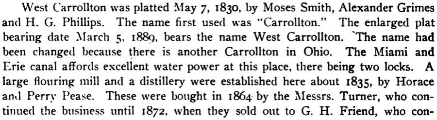
West Carrollton was platted May 7, 1830, by Moses Smith, Alexander Grimes and H. G. Phillips. The name first used was **Carrollton." The enlarged plat bearing date March 5, 1889, bears the name West Carrollton. The name had been changed because there is another Carrollton in Ohio. The Miami and Erie canal aflPords excellent water power at this place, there being two locks, A large flouring mill and a distillery were estabHshed here about 1835, by Horace anil Perry Pease. These were bought in 1864 by the Messrs. Turner, who continued the business until 1872, when they sold out to G. H. Friend, who con-
Text read by machine from the scan; it may contain errors.
Scans and text from the Internet Archive. Books published in 1930 or earlier, which are in the public domain.
Timeline
West Carrollton, 1828 to 1955
Woven from the archive, old maps, post office records, the National Register and the people born here.
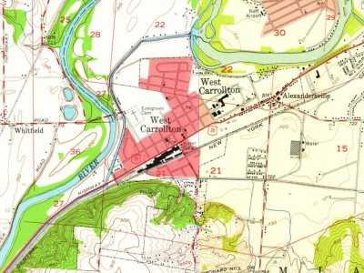
Every edition of the U.S. Geological Survey’s map of West Carrollton. Tap a year, or press play to watch the town change.
1955Miamisburg sheet · 1:24,000
U.S. Geological Survey historical topographic maps (public domain), via Esri’s collection of the scans. The red ring marks the center of West Carrollton.
Every building
West Carrollton, building by building, 1918
Fire insurance maps drew every building, what it was made of and what it was used for, so insurers could price the risk of fire. Pick a sheet.
The West Carrollton post office opened in 1870, the earliest record of the town by name (U.S. post office records).
How does West Carrollton rank for history?
West Carrollton is more historic than 27% of U.S. towns, #870 of 993 in Ohio. The History grade combines the town’s founding era, the share of homes built before 1940 and its National Register listings. It’s a character grade, so it isn’t part of the overall grade. How it works.
How old are the homes in West Carrollton?
9% of West Carrollton’s homes were built before 1940 (Census estimate, ±3.3 points), against a typical 15% for an Ohio town; the median home was built in 1973.
Founding dates: Wikidata, Wikipedia, the U.S. post office records of Blevins & Helbock (CC0) and the Census. Homes by year built: Census ACS 2020–24. National Register of Historic Places: National Park Service (list of May 22, 2026). Old photos, postcards and papers: Wikimedia Commons, the Library of Congress and other public archives, credited on each item’s page. Maps: U.S. Geological Survey historical topographic maps (via Esri) and Sanborn fire-insurance maps (Library of Congress). History text and census tables: Wikipedia (CC BY-SA 4.0). Places that used to be: USGS Geographic Names Information System (2021).
From Wikidata (1), Wikipedia, U.S. Geological Survey historical maps, U.S. Census counts (via Wikipedia), the US Post Offices dataset (Blevins & Helbock), the USGS Geographic Names Information System, Sanborn fire insurance maps (Library of Congress) and old county and town histories (Internet Archive). Archive images are copied here with their credits and licenses, shown on each photo’s page. Refreshed monthly.