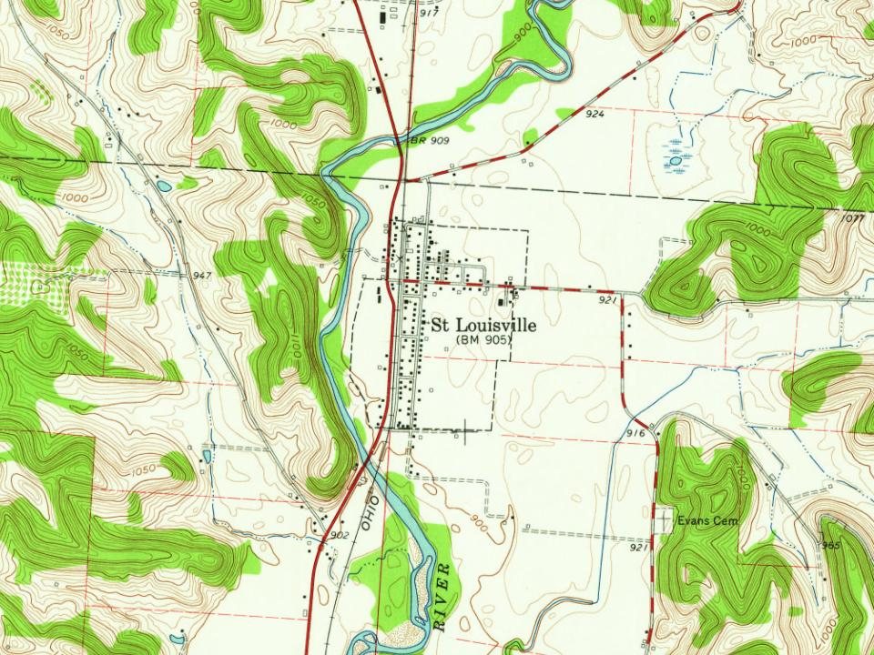
Every edition of the U.S. Geological Survey’s map of St. Louisville. Tap a year, or press play to watch the town change.
1909Newark sheet · 1:62,500
U.S. Geological Survey historical topographic maps (public domain), via Esri’s collection of the scans. The red ring marks the center of St. Louisville.
The story so far
St. Louisville, in brief
Wikipedia doesn’t have a history of St. Louisville yet. The photos, dates and memories neighbors add here are how it gets written.
Its first post office opened in 1840. Between the 2010 and 2020 censuses its population fell from 373 to 352 (-6%).
From the old history books
What they wrote about St. Louisville, 1876–1909
Passages that mention St. Louisville, cut from the printed page as they were published.
Centennial history of Licking County, Ohio1876 · page 47Read the page →
Read the text
William Kinning, a vScotch batchelor, reputed to have some means, boarded with a family that lived in the North Fork Valley in 1810, eight miles above Newark. While in the act of crossing the North Fork on a log, near the present village of St. Louisville, he received a rifle ball in his bod}', which it was long supposed would prove fatal, but he ultimately recovered. Tracks on the snow and other circumstances pointed to a man living in that vicinity by the name of Hoyt, as the would-be assassin. The suspected culprit fled
Text read by machine from the scan; it may contain errors.
Centennial History of the City of Newark and Licking County Ohio1909 · page 625Read the page →
Read the text
ninety-seven acres, and one seventy acres, having two hundred and seventy-seven acres of land under cultivation. In addition to these tracts of land he possesses six acres in Newton township, together with a number of lots in the village of St. Louisville. His farming interests are of large proportions and he pays particular attention to potato, corn and wheat crops, raising in the neighborhood of twenty-five hundred bushels of corn, one thousand bushels of potatoes, eight hundred bushels of wheat and seventy-five tons of hay annually together with from seventy-five to one hundred head of hogs and last year his harvests brought him
Text read by machine from the scan; it may contain errors.
Centennial History of the City of Newark and Licking County Ohio1909 · page 752Read the page →
Read the text
Reared in the village of St. Louisville, Bryant L. Hawke devoted much of his time in his youthful days to the mastery of the branches of learning taught in the public schools. He afterward entered the Hanover high school, from which he was graduated in the class of 1892. He then took up the profession of teaching, which he followed for eleven years, beginning at the age of twenty and in that field of labor he proved competent, capable and successful. He was also employed in the county treasurer’s office for a year and a half prior to his connection with the Hebron Bank Company, which was organized in 1903. At that time he came to the
Text read by machine from the scan; it may contain errors.
History of Licking County, Ohio1881 · page 580Read the page →
Read the text
in an early day, and Rev. John Fry was one of its early-time preachers. The society was never very large. They erected their first church edifice in St. Louisville in the earliest years of that village, and in 1849 sold it to the Christian or New Light society. Soon after, they erected a small log church on Lost run, about three miles east of St.
Text read by machine from the scan; it may contain errors.
Scans and text from the Internet Archive. Books published in 1930 or earlier, which are in the public domain.
Founding dates: Wikidata, Wikipedia, the U.S. post office records of Blevins & Helbock (CC0) and the Census. Homes by year built: Census ACS 2020–24. National Register of Historic Places: National Park Service (list of May 22, 2026). Old photos, postcards and papers: Wikimedia Commons, the Library of Congress and other public archives, credited on each item’s page. Maps: U.S. Geological Survey historical topographic maps (via Esri) and Sanborn fire-insurance maps (Library of Congress). History text and census tables: Wikipedia (CC BY-SA 4.0). Places that used to be: USGS Geographic Names Information System (2021). How TownRatings grades history →
From Wikimedia Commons (6), U.S. Geological Survey historical maps, U.S. Census counts (via Wikipedia), the US Post Offices dataset (Blevins & Helbock), the USGS Geographic Names Information System and old county and town histories (Internet Archive). Archive images are copied here with their credits and licenses, shown on each photo’s page. Refreshed monthly.



 2016
 2016
 2016
 2016
 2015
 2004