Guest, Sign inJoin

Post to Palestine

We’ll email a one-tap link to publish your post. No password, and nothing is public until you click it.
Already a member? Sign in
–Not graded
History · Palestine

Palestine dates to 1833, and 42% of its homes were built before 1940

Below: maps from 1961 on and the census since 1870.

1833founded
0on the National Register
42%homes built before 1940
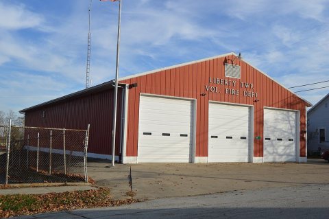
Photo: Nyttend · Public domain
Quick answers

How Palestine began

When was Palestine founded?

1833

Palestine dates its founding to 1833 (Wikipedia’s history). The census first counted it in 1870.

First census: 264 in 18702020 census: 180193 years
Founding year: Wikipedia. First post office: 1835.The full story ↓

What stands out about Palestine’s past

Read from the archive, the National Register and the record. The page puts what stands out first.

★ What stands out · Help out

Start Palestine’s collection

The first neighbors to add old photos shape how Palestine’s history is told.

Decades since 1900 with photos
00s10s20s30s40s50s60s70s80s90s
0 of 10 decades. The empty ones are waiting for someone’s album.
The story

How Palestine came to be

From Wikipedia’s history of Palestine.

Read it all →

Palestine was platted by Samuel Loring in 1833. It has always been a small community, although its population declined during the twentieth century; the 1910 census recorded 216 residents.

Text from Wikipedia, licensed CC BY-SA 4.0.

Timeline

Palestine, 1833 to 1961

Woven from the archive, old maps, post office records, the National Register and the people born here.

  1. 19th century
  2. 1833
    FoundingPalestine is established
  3. 1835Post officeThe German post office opens
  4. 20th century
  5. 1901Post officeThe German post office closes
  6. 1901Post officeThe Palestine post office opens
  7. 1961On the mapFirst mapped by the U.S. Geological Survey
From the old history books

What they wrote about Palestine, 1880–1914

Passages that mention Palestine, cut from the printed page as they were published.

named, about 181 (i. but little was known of this man more than that he came originally from South Carolina, as did. also, Alexander Pearson, who was. perhaps, the third settler. Samuel Loring, who settled on the southwest quarter of Section 14. and who laid out the town of Palestine, was the next …
The history of Darke County, Ohio, containing a history of the county1880 · page 446Read the page →
Read the text

named, about 181 (i. but little was known of this man more than that he came originally from South Carolina, as did. also, Alexander Pearson, who was. perhaps, the third settler. Samuel Loring, who settled on the southwest quarter of Section 14. and who laid out the town of Palestine, was the next permanent settler. Peter Crumrine moved into German Township on March 12, 1817. The name of Daniel Wagner is associated with those of the pioneers. The family of which he was a member located on the northeast quarter of Section 24, on the edge of the prairie. They were originally from Berks County. Penn.. whence the}'

Text read by machine from the scan; it may contain errors.
Palestine is the only village of importance in German township. It was laid out in 1833 by Samuel Loring. It now has two churches, a high school, a town hall and is known as a good trading center, but having no railway or traction facilities has made but slow growth, its population in 1910 being 21…
History of Darke County, Ohio, from its earliest settlement to the present time ..1914 · page 555Read the page →
Read the text

Palestine is the only village of importance in German township. It was laid out in 1833 by Samuel Loring. It now has two churches, a high school, a town hall and is known as a good trading center, but having no railway or traction facilities has made but slow growth, its population in 1910 being 216. Although there are but a few miles of railway in the southern part of this township, the real property was assessed in 1913 at $2,030,750 and the personal property at

Text read by machine from the scan; it may contain errors.
In the village of Palestine, Darke county, he began practicing, remaining there for eight years, when, wishing to seek a broader field of labor, he took up his abode in Greenville, where he has since remained. He has gained a prestige which many an older practitioner might envy and excellent result…
A Biographical history of Darke County, Ohio1900 · page 569Read the page →
Read the text

In the village of Palestine, Darke county, he began practicing, remaining there for eight years, when, wishing to seek a broader field of labor, he took up his abode in Greenville, where he has since remained. He has gained a prestige which many an older practitioner might envy and excellent results have attended his care of the sick, making him a

Text read by machine from the scan; it may contain errors.
an early da}*, and spoke to the people of things eternal and spiritual. They were ministers of the German Baptist Church. The first church built in this township was known as the "St. John's," a Lutheran enterprise, erected in 1826, south of Palestine, on land owned by John Ketring. The old structu…
The history of Darke County, Ohio, containing a history of the county1880 · page 447Read the page →
Read the text

an early da}*, and spoke to the people of things eternal and spiritual. They were ministers of the German Baptist Church. The first church built in this township was known as the "St. John's," a Lutheran enterprise, erected in 1826, south of Palestine, on land owned by John Ketring. The old structure was constructed of tree-trunks cut from the forest surrounding, but. in 1868, this was supplanted by a more comfortable and pretentious frame building. The old church was used by the Lutherans alone for many years, and then the German Reformed organization united with them, the two using the same church, employing the same minister, but

Text read by machine from the scan; it may contain errors.

Scans and text from the Internet Archive. Books published in 1930 or earlier, which are in the public domain.

By decade

Palestine, decade by decade

On the map

Palestine on the map, 1961 to 1973

Every edition of the U.S. Geological Survey’s map of Palestine. Tap a year, or press play to watch the town change.

Palestine on the 1961 USGS mapPalestine on the 1973 USGS map1961Greenville West sheet · 1:24,000

U.S. Geological Survey historical topographic maps (public domain), via Esri’s collection of the scans. The red ring marks the center of Palestine.

People over time

Palestine, census by census

010020018801900192019401960198020002020Peak: 264

Between 170 and 264 people in every census since 1870.

15 censuses, 1870–2020.

U.S. Census Bureau decennial counts, from the census table on Palestine’s Wikipedia page.

Places that used to be

Lost post offices

Palestine’s post office has been open since 1901. Another post office, German, opened and closed inside today’s town.

German
1835–1901
Palestine
1901–today
18301930today

US Post Offices dataset (Blevins & Helbock, CC0). Places and cemeteries from the USGS Geographic Names Information System (2021).

Questions about Palestine’s history

What year was Palestine founded?

In 1833, according to Wikipedia’s history of the town. Palestine’s post office opened in 1835, and the census of 1870 counted 264 people here.

Memory lane

What the archives can’t tell you, neighbors can.

Town Square →
Start a conversation
Sources

Where this page comes from

Founding dates: Wikidata, Wikipedia, the U.S. post office records of Blevins & Helbock (CC0) and the Census. Homes by year built: Census ACS 2020–24. National Register of Historic Places: National Park Service (list of May 22, 2026). Old photos, postcards and papers: Wikimedia Commons, the Library of Congress and other public archives, credited on each item’s page. Maps: U.S. Geological Survey historical topographic maps (via Esri) and Sanborn fire-insurance maps (Library of Congress). History text and census tables: Wikipedia (CC BY-SA 4.0). Places that used to be: USGS Geographic Names Information System (2021). How TownRatings grades history →

From Wikimedia Commons (6), Wikipedia, U.S. Geological Survey historical maps, U.S. Census counts (via Wikipedia), the US Post Offices dataset (Blevins & Helbock), the USGS Geographic Names Information System and old county and town histories (Internet Archive). Archive images are copied here with their credits and licenses, shown on each photo’s page. Refreshed monthly.