Norwich was laid out in 1827, and named after Norwich, in England, the native home of a first settler. A post office has been in operation at Norwich since 1828. By 1833, Norwich had four stores, two churches, and two taverns. The village was incorporated in 1833.
Peaked at 324 in 1850; 87 people lived here in 2020.
19 censuses, 1830–2020.
U.S. Census Bureau decennial counts, from the census table on Norwich’s Wikipedia page.
From the old history books
What they wrote about Norwich, 1882–1897
Passages that mention Norwich, cut from the printed page as they were published.
A genealogical history of the Kelley family1897 · page 15Read the page →
Read the text
In the History of Norwich above referred to we find the following entries, taken from the town records of Norwich: "Joseph Kelley, resident of Norwich, 1716."
Text read by machine from the scan; it may contain errors.
A genealogical history of the Kelley family1897 · page 13Read the page →
Read the text
1. JOSEPH KELLEY (1>, the first of the family concerning whom we possess reliable information, was born about the year 1690. He was one of the early settlers of Norwich, Connecticut,* which town had been purchased from the Indians in June, 1659, "by 35 men" and first settled by white men in the spring of 1660. In Caulkins' History of Norwich his name appears as a resident of that place in 1716, and that of one Thomas Kelley in 1719, "Probably both from Newberry."
Text read by machine from the scan; it may contain errors.
1794. History of Muskingum County, Ohio, with illustrations and biographical sketches of prominent men and pioneers1882 · page 423Read the page →
Read the text
Sundale postoffice was established at the railroad depot, near Norwich, in April, 1880. J. P. Kelly, postmaster. PHYSICIANS.
Text read by machine from the scan; it may contain errors.
1794. History of Muskingum County, Ohio, with illustrations and biographical sketches of prominent men and pioneers1882 · page 417Read the page →
Read the text
Harper & Keitly built a "tramp sawmill," just south of lot twelve, in the town of Norwich, in 1827, which was afterwards turned into a brewery by Holley & Son. Applin & Abbitson were also its proprietors for a time. Finally it was turned into a tanner}', by James Caldwell.
Text read by machine from the scan; it may contain errors.
Scans and text from the Internet Archive. Books published in 1930 or earlier, which are in the public domain.
Timeline
Norwich, 1820 to 1995
Woven from the archive, old maps, post office records, the National Register and the people born here.
National Park Service, National Register of Historic Places. Photos from Wikimedia Commons, credited on each place’s page.
Places that used to be
Lost post offices, places now gone and burying grounds
Norwich’s post office has been open since 1828. Another post office, McDonalds, opened and closed inside today’s town.
McDonalds
1820–1828
Norwich
1828–today
18201920today
Gone or out of use
Norwich Schoolschool
1cemetery inside Norwich
Norwich United Presbyterian
US Post Offices dataset (Blevins & Helbock, CC0). Places and cemeteries from the USGS Geographic Names Information System (2021).
Questions about Norwich’s history
What year was Norwich founded?
In 1827, according to Wikidata and Wikipedia’s history of the town. Norwich’s post office opened in 1820, and the census of 1830 counted 206 people here.
What is on the National Register in Norwich?
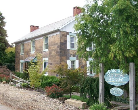
One place: the Hardesty, Ralph, Stone House (listed 1980).
Founding dates: Wikidata, Wikipedia, the U.S. post office records of Blevins & Helbock (CC0) and the Census. Homes by year built: Census ACS 2020–24. National Register of Historic Places: National Park Service (list of May 22, 2026). Old photos, postcards and papers: Wikimedia Commons, the Library of Congress and other public archives, credited on each item’s page. Maps: U.S. Geological Survey historical topographic maps (via Esri) and Sanborn fire-insurance maps (Library of Congress). History text and census tables: Wikipedia (CC BY-SA 4.0). Places that used to be: USGS Geographic Names Information System (2021). How TownRatings grades history →
From Wikimedia Commons (6), the Library of Congress (1), the National Register of Historic Places (1), Wikipedia, Wikidata and Wikipedia for famous people, U.S. Geological Survey historical maps, U.S. Census counts (via Wikipedia), the US Post Offices dataset (Blevins & Helbock), the USGS Geographic Names Information System and old county and town histories (Internet Archive). Archive images are copied here with their credits and licenses, shown on each photo’s page. Refreshed monthly.


 Date?
 2018
 2018
 2015
 2009
 2004


