North Bend’s post office opened in 1807, and 29% of its homes were built before 1940
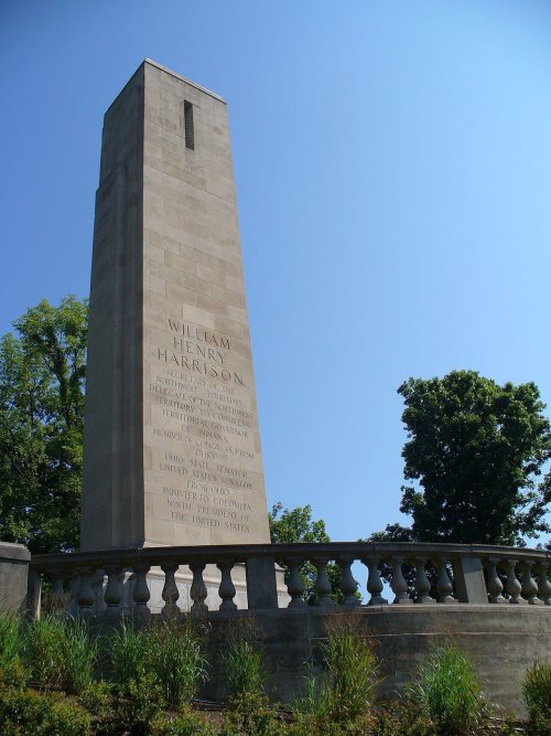
Its Register listings are the William Henry Harrison Tomb State Memorial, the John Aston Warder House and the Cincinnati and Whitewater Canal Tunnel. Below: 6 old photos and papers from 1790 on and old-book passages.
North Bend was founded in 1789. It was platted as Symmes City but ultimately never took that name. Instead, it was incorporated as the village of North Bend in 1845. It is named for its location, where the Ohio River meanders to the north.
Passages that mention North Bend, cut from the printed page as they were published.
History of Hamilton County, Ohio, with illustrations and biographical sketches1881 · page 331Read the page →
Read the text
North Bend village proper, has had no large growth, and is now simply a moderate cluster of houses at the original site. A large town plat, however, known by the same name, has been laid out for more than three miles along the river, with a width of about two-thirds of a mile west of North Bend station, and over two miles east of it — that is, three sections wide, and extending back from the river something more than half a mile at
Text read by machine from the scan; it may contain errors.
History of Hamilton County, Ohio, with illustrations and biographical sketches1881 · page 323Read the page →
Read the text
The result was a determination to lay out a village where the party had first landed. He accordingly platted the village of North Bend, and South Bend some time after. He kept looking about, however, for a suitable site for a city, and seems to have found two, "both eligible," one about two miles east of North Bend, on the Ohio, a little above the mouth of Muddy creek; the other the same distance north of the bend, in that
Text read by machine from the scan; it may contain errors.
History of Cincinnati and Hamilton County, Ohio1894 · page 37Read the page →
Read the text
Limestone as a military escort, had refused to build a fort at North Bend, and had taken his troops to the Falls of the Ohio. Ensign Luce, who had been dispatched to North Bend with a smaller detachment in his place, on the 21st of May undertook to escort a number of citizens from North Bend to a point farther up the river. On the way their boat received an unexpected volley from the shore, which killed a soldier and wounded live others. Hardly a month of the year passed without bereaving some family among the settlers. Abraham Covalt, a member of Capt. Covalt’s household, “one of as brave sons of Pennsylvania as ever inhaled the morning air,” was killed
Text read by machine from the scan; it may contain errors.
History of Cincinnati and Hamilton County, Ohio1894 · page 419Read the page →
Read the text
nected White’s Station with Columbia, crossing Harmar’s trace one mile southeast of the present village; another led east to Covalt’s Station, on the Little Miami; and another road, on the old Indian trail, passed near Griffin’s (Caldwell’s mill) westward to the Great Miami, and on to North Bend. This road connected almost directly with Dunlap’s or Colerain Station on the Great Miami. Between White’s and Griffin’s Stations (in Upper Carthage) passed the great road from Fort Hamilton southward to Ludlow’s Station (North Cumminsville), and thence to Cincinnati.”
Text read by machine from the scan; it may contain errors.
Scans and text from the Internet Archive. Books published in 1930 or earlier, which are in the public domain.
By decade
North Bend, decade by decade
3 decades in the archive, from the 1790s to the 1840s. Scroll each row; tap a photo for its story.
The North Bend post office opened in 1807, the earliest record of the town by name (U.S. post office records).
What is on the National Register in North Bend?
Three places: the William Henry Harrison Tomb State Memorial (listed 1970), the John Aston Warder House (1978) and the Cincinnati and Whitewater Canal Tunnel (2001).
Founding dates: Wikidata, Wikipedia, the U.S. post office records of Blevins & Helbock (CC0) and the Census. Homes by year built: Census ACS 2020–24. National Register of Historic Places: National Park Service (list of May 22, 2026). Old photos, postcards and papers: Wikimedia Commons, the Library of Congress and other public archives, credited on each item’s page. Maps: U.S. Geological Survey historical topographic maps (via Esri) and Sanborn fire-insurance maps (Library of Congress). History text and census tables: Wikipedia (CC BY-SA 4.0). Places that used to be: USGS Geographic Names Information System (2021). How TownRatings grades history →
From Wikimedia Commons (6), the National Register of Historic Places (3), Wikipedia, Wikidata and Wikipedia for famous people, the US Post Offices dataset (Blevins & Helbock), the USGS Geographic Names Information System and old county and town histories (Internet Archive). Archive images are copied here with their credits and licenses, shown on each photo’s page. Refreshed monthly.


 1810
 1840
 1840