Newtown dates to 1792, and 17% of its homes were built before 1940
More historic than 83% of U.S. towns · #262 of 993 in Ohio. What drives it
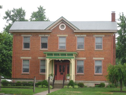
Its Register listings are the Martin House, the Edwards, William, Farmhouse and the Joseph Martin House. Below: 13 old photos and papers, maps from 1898 on, and the census since 1880.
Founding year: Wikipedia. First post office: 1816.The full story ↓
History grade
What drives Newtown’s History grade
On its age, its old homes and the National Register, Newtown is more historic than 83% of U.S. towns, #262 of 993 in Ohio. All 3 inputs are above most U.S. towns; its age ranks highest and its share of homes from before 1940 lowest.
A−
HistoryA character grade: shown, never part of Newtown’s overall grade.
Ohio towns list about as much on the Register as the country (a typical Ohio town has 2.9 per 10,000 residents, the U.S. 2.4), so Newtown’s 14.9 sits above most of its state (78% of Ohio towns have fewer) while its 4 historic buildings outnumber those of 68% of U.S. towns.
How sure. Graded on any two of the three inputs instead, the letter would still be A−. The pre-1940 share is a Census survey estimate (±12.9 points). Two sources give 1792.
Founding year: Wikipedia (other dates in Quick answers). Homes: Census ACS 2020–24. National Register: National Park Service, May 2026 list; each listing counted once (boundary changes and added documentation belong to their listing), and a historic district counts its contributing buildings. How TownRatings grades history →
What stands out about Newtown’s past
Read from the archive, the National Register and the record. The page puts what stands out first.
Nothing in the archives for these yearsWeddings on Main Street, storms, parades, school pictures, the old store. If it’s in your family album, it belongs here.
Multiple Native American mounds and other earthworks were once located on the site of Newtown.
Newtown was first settled in 1792 under the name of Mercersburg. The name was changed before the village incorporated in 1901. Still in existence today are the Odd Fellows' Cemetery Mound and the Perin Village Site, plus the Turpin site and the Hahn Field Archeological District just outside the village's boundaries.
Newtown withdrew from Anderson Township in the 1960s by forming a paper township.
Passages that mention Newtown, cut from the printed page as they were published.
History of Hamilton County, Ohio, with illustrations and biographical sketches1881 · page 252Read the page →
Read the text
A stone building was erected at Newtown in 18 13 for the use of the Methodist Episcopal church. When a new meeting-house was put up on the same site in 1861, the stones used for this basement were taken from the old building. Rev. John Strange was the first circuitrider to serve the Methodist charge here. The Revs.
Text read by machine from the scan; it may contain errors.
History of Cincinnati and Hamilton County, Ohio1894 · page 380Read the page →
Read the text
Newtown , notwithstanding its name, is one of the oldest villages in the county. It was laid out by Elijah Yates for Gen. James Taylor, who gave it the name of Mercersburg, in honor of the Revolutionary hero, Gen. Mercer. There was a collection of improvements here as early as 1798, and early in this century the village had attained fair proportions. Among early merchants were William E. White, John H. Gerrard and Henry Diebolt; John D. Garr, shoemaker; Hubbard Brown, blacksmith; Henry Crossley, carpenter, and George Earhart, wagon maker, were early representatives of their respective vocations. The “Miami House,’ ’ of which
Text read by machine from the scan; it may contain errors.
History of Hamilton County, Ohio, with illustrations and biographical sketches1881 · page 242Read the page →
Read the text
Little Miami at various points in the township above Clough creek; and channels or mill-races of some size, in two instances, connect points on the river northeast, northwest, and north of Newtown, thus virtually forming islands of two and a half to three miles in circumference, which nearly adjoin each other just opposite Plainville, and about a mile due north from Newtown. It is a remark-
Text read by machine from the scan; it may contain errors.
Scans and text from the Internet Archive. Books published in 1930 or earlier, which are in the public domain.
On the map
Newtown on the map, 1898 to 1914
Every edition of the U.S. Geological Survey’s map of Newtown. Tap a year, or press play to watch the town change.
1898East Cincinnati sheet · 1:62,500
U.S. Geological Survey historical topographic maps (public domain), via Esri’s collection of the scans. The red ring marks the center of Newtown.
Then & now
Stand where they stood
No then-and-now pairs yet. Take a photo from the same spot as an old one and they appear here side by side.
Retake this viewA CAR OWNER REVIEWS THE RESULTS OF HIS CAR'S INSPECTION WITH AN EMPLOYEE OF THE HAMILTON COUNTY AUTO EMISSION... - NARA…, 1975
Find the spot, match the angle, and add your photo. It becomes the first then-and-now pair on Newtown’s page.
In 1792, according to Wikipedia’s history of the town. Newtown’s post office opened in 1816, and the census of 1880 counted 424 people here.
How does Newtown rank for history?
Newtown is more historic than 83% of U.S. towns, #262 of 993 in Ohio. The History grade combines the town’s founding era, the share of homes built before 1940 and its National Register listings. It’s a character grade, so it isn’t part of the overall grade. How it works.
What is on the National Register in Newtown?
Three places: the Martin House (listed 1979), the Edwards, William, Farmhouse (1989) and the Joseph Martin House (1984).
How old are the homes in Newtown?
17% of Newtown’s homes were built before 1940 (Census estimate, ±12.9 points), against a typical 15% for an Ohio town; the median home was built in 1989.
Founding dates: Wikidata, Wikipedia, the U.S. post office records of Blevins & Helbock (CC0) and the Census. Homes by year built: Census ACS 2020–24. National Register of Historic Places: National Park Service (list of May 22, 2026). Old photos, postcards and papers: Wikimedia Commons, the Library of Congress and other public archives, credited on each item’s page. Maps: U.S. Geological Survey historical topographic maps (via Esri) and Sanborn fire-insurance maps (Library of Congress). History text and census tables: Wikipedia (CC BY-SA 4.0). Places that used to be: USGS Geographic Names Information System (2021).
From Wikimedia Commons (17), the Library of Congress (1), the National Register of Historic Places (3), Wikipedia, Wikidata and Wikipedia for famous people, U.S. Geological Survey historical maps, U.S. Census counts (via Wikipedia), the US Post Offices dataset (Blevins & Helbock), the USGS Geographic Names Information System and old county and town histories (Internet Archive). Archive images are copied here with their credits and licenses, shown on each photo’s page. Refreshed monthly.


 1975
 1975
 1975
 1975
 1975
 1975
 1975
 1975
 1975
 1975
 1975
 Date?
 Date?
 2016
 2015
 2011
 2010
 2004