Monfort HeightsOH
A town of 12,441.
Is Monfort Heights a good place to live?
Monfort Heights gives you more for your money than most places: homes are within reach, about $234K for a typical one, or 2.9 years of the Cincinnati metro’s $81K median household income. It grades A overall, 156th of 987 graded towns in Ohio. On the plus side, the median household earns $88K. On health, just 168 of Ohio’s 1,718 towns do better. 1.9% of residents live below the poverty line in Monfort Heights, below both the Ohio town median (9.1%) and the median of U.S. towns (9.6%). The biggest park or preserve is Bicentennial Park, at 43 acres.
What makes Monfort Heights stand out
Where Monfort Heights beats most towns.
97% of working residents leave Monfort Heights for work
Where Monfort Heights’s working residents go each day. Line width shows the share.
Census LEHD 2023
How Monfort Heights grades
Each subject compared with towns across the country (schools within Ohio), ordered by how far Monfort Heights is from typical.
How TownRatings grades towns →
Paycor Stadium and 52 more within 40 miles
Museums, parks, gardens and other places to visit around Monfort Heights. Close and well known come first.
 8 mi Stadium & arenaPaycor Stadium
 Big draw21 mi Theme parkKings Island3.5M visitors a year
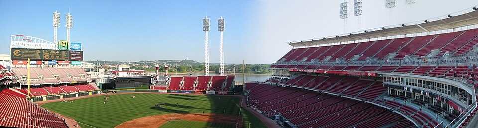 8 mi Stadium & arenaGreat American Ball Park
 Big draw39 mi Theme parkArk Encounter
 6 mi Stadium & arenaNippert Stadium
 6 mi Zoo & aquariumCincinnati Zoo and Botanical Garden1.2M visitors a year
Photo credits
Paycor Stadium: JonRidinger, CC BY-SA 4.0 · Kings Island: Eli Duke from Portland, OR, USA, CC BY-SA 2.0 · Great American Ball Park: Eric Kilby profile at Flickr website, CC BY-SA 2.0 · Ark Encounter: OlinEJ, CC0 · Nippert Stadium: Ben Levin, CC BY-SA 4.0 · Cincinnati Zoo and Botanical Garden: Unknown, CC BY-SA 2.5


Moving to Monfort Heights: who provides what
Monfort Heights is unincorporated, so Hamilton County and regional agencies provide most services.
EPA SDWIS (Oct 9, 2026) · HIFLD + EIA-861 2025 · Census 2020 ZCTAs · NCES 2024–25 · registration: vote.gov, updated Aug 3, 2026.
The data
Ordered by what stands out in Monfort Heights.
Monfort Heights ranks healthier than 79% of the country’s towns
Its widest gap with Ohio is food insecurity: 9% of its 9,708 adults worry about having enough food, against 14.1% statewide.
A quarter of Monfort Heights adults have been diagnosed with depression. Of 32 CDC measures, Monfort Heights beats the Ohio average on 17 and trails it on 1. In Monfort Heights, 12% of adults smoke cigarettes, and 21% get no exercise outside work.
| Monfort Heights | Ohio towns | U.S. towns | |
|---|---|---|---|
| Frequent physical distress (CDC PLACES) | 12% | 15% | 14% |
| Smoke cigarettes (CDC PLACES) | 12% | 16% | 14% |
| Get no exercise (CDC PLACES) | 21% | 28% | 25% |
| Obesity (CDC PLACES) | 32% | 38% | 35% |
| What stands out | Monfort Heights | OH |
|---|---|---|
| Fewer adults facing food insecurity | 9% | 14.1% |
| Fewer adults facing a utility shut-off | 5.7% | 8.3% |
| More adults who have had cancer | 10.1% | 8.7% |
CDC PLACES 2025 · modeled estimates for adults · CMS · HRSA
Very low risk in Monfort Heights, with inland flooding at the top
The FEMA hazard score in Monfort Heights is 19 of 100. FEMA puts 37% of the town’s expected hazard losses down to inland flooding, and 30% to tornadoes. Since 1979, 8 flood insurance claims have been paid out locally.
FEMA flood insurance claims · FEMA National Risk Index · OpenFEMA
Most of Monfort Heights’ workers head elsewhere: there are 0.6 jobs for each of them
The top destinations are Cincinnati (32%), Blue Ash (3%) and West Chester Township (3%). Since 2013, Monfort Heights has added 611 jobs, to 3,401 in 2023. The share of working residents in Monfort Heights who work locally: 2.8%. Half the trips to work are shorter than 9 miles.
| Monfort Heights | Ohio towns | U.S. towns | |
|---|---|---|---|
| Work from home | 15% | 9.7% | 11% |
| Working residents who work in town | 2.8% | 6.9% | 8% |
| Median household income | $88,000 | $75,000 | $80,000 |
Where working residents work
Census LEHD 2023 · ACS
Monfort Heights keeps 1.8% of its land conserved
1.1 miles of trail wind through 2 parks and preserves. Monfort Heights’ trail density comes in at 0.2 miles per square mile.
| Monfort Heights | Ohio towns | U.S. towns | |
|---|---|---|---|
| Conserved land | 1.8% | 3.7% | 4.3% |
| Miles of trail per square mile | 0.2 miles per square mile | 0.2 | 0.4 |
| Biggest places to walk | Trails | Acres |
|---|---|---|
| 1. Bicentennial Park | 0.9 mi | 43 |
| 2. Mount Airy Forest | — | 2 |
Trails & parks © OpenStreetMap contributors · Conserved land: USGS PAD-US
The climate in Monfort Heights brings four seasons and pleasant summers
In July, afternoons reach 85°; in January, nights fall to 22°, and about 16 inches of snow falls in a winter.
Typical low → high °F
NOAA U.S. Climate Normals, 1991–2020
A home in Monfort Heights sells for about $375K at the median
Homes sold in Monfort Heights spent a median 33 days on the market. 79% of households are owner-occupiers in the town. In Monfort Heights, just over three in five sales closed above the list price.
| Monfort Heights | Ohio towns | U.S. towns | |
|---|---|---|---|
| Households that own their home | 79% | 77% | 73% |
| Median rent | $1,065 a month | $943 a month | $1,185 a month |
Census ACS, 2020–24 · Zillow Home Value Index · Redfin Data Center
Everything we know about Monfort Heights
Colleges nearby
17 within 15 miles of the center of Monfort Heights
About 3 of every 100 Monfort Heights residents are enrolled in college, against 6 across Ohio.
About Monfort Heights
Census-designated place in Ohio, United States
Monfort Heights is a census-designated place (CDP) in Green Township, Hamilton County, Ohio, United States, part of the Cincinnati–Northern Kentucky metropolitan area. The population of Monfort Heights was 12,070 at the 2020 census. In previous censuses, the area was listed as two separate CDPs, Monfort Heights East and Monfort Heights South.
From Wikipedia, licensed CC BY-SA 4.0 · facts via Wikidata (CC0)
- Area
- 6.5 sq mi
- Elevation
- 930 ft
Monfort Heights’s neighbors
6 towns share a border with Monfort Heights.
| Town | OH rank | Overall | Cost | Safety | Schools | Health |
|---|---|---|---|---|---|---|
| Monfort Heights | #156 | A | B | — | C+ | A− |
| Green Township | #285 | B+ | B | B− | B | B+ |
| White Oak | #453 | B | B | — | C+ | B |
| Cincinnati | #957 | D | C+ | D− | C | C |
| Dent | #333 | B+ | C+ | — | B+ | A− |
| Bridgetown | #20 | A+ | A− | — | B+ | B+ |
| Cheviot | #829 | C | A− | C | C | C |
Monfort Heights, White Oak, Dent and Bridgetown report no FBI crime data of their own. Compare Monfort Heights with a neighbor →
Questions about Monfort Heights
Short answers, built from the data on this page.
Is Monfort Heights, OH a good place to live?
By most measures, yes. Monfort Heights grades A overall, better than 85% of U.S. towns and #156 of 987 in Ohio. It grades A− for health and C+ for schools.
Is Monfort Heights, OH expensive?
The typical home is worth about $234,000, 5% below the Ohio typical home. Cost of living, which also weighs rents, property taxes and how many households pay 30% or more of their income for housing, grades B.